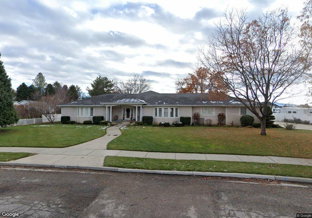
6439 W 10900 N Highland, UT 84003
Estimated Value: $778,000 - $984,000
2
Beds
3
Baths
2,874
Sq Ft
$317/Sq Ft
Est. Value
About This Home
This home is located at 6439 W 10900 N, Highland, UT 84003 and is currently estimated at $910,686, approximately $316 per square foot. 6439 W 10900 N is a home with nearby schools including Highland Elementary School, Mountain Ridge Junior High School, and Lone Peak High School.
Ownership History
Date
Name
Owned For
Owner Type
Purchase Details
Closed on
Sep 21, 2017
Sold by
Leeuwen Max J Van and Leeuwen Carol A Van
Bought by
Leeuwen Max J Van and Leeuwen Carol Van
Current Estimated Value
Home Financials for this Owner
Home Financials are based on the most recent Mortgage that was taken out on this home.
Original Mortgage
$143,000
Interest Rate
3.9%
Mortgage Type
New Conventional
Purchase Details
Closed on
Mar 16, 2010
Sold by
Vanleeuwen Max J and Van Leeuwen Carol
Bought by
Vanleeuwen Max J and Van Leeuwen Carol
Create a Home Valuation Report for This Property
The Home Valuation Report is an in-depth analysis detailing your home's value as well as a comparison with similar homes in the area
Home Values in the Area
Average Home Value in this Area
Purchase History
| Date | Buyer | Sale Price | Title Company |
|---|---|---|---|
| Leeuwen Max J Van | -- | Accommodation | |
| Vanleeuwen Max J | -- | None Available | |
| Vanleeuwen Max J | -- | None Available |
Source: Public Records
Mortgage History
| Date | Status | Borrower | Loan Amount |
|---|---|---|---|
| Closed | Leeuwen Max J Van | $143,000 |
Source: Public Records
Tax History Compared to Growth
Tax History
| Year | Tax Paid | Tax Assessment Tax Assessment Total Assessment is a certain percentage of the fair market value that is determined by local assessors to be the total taxable value of land and additions on the property. | Land | Improvement |
|---|---|---|---|---|
| 2025 | $2,982 | $420,860 | $328,900 | $436,300 |
| 2024 | $2,982 | $368,335 | $0 | $0 |
| 2023 | $2,732 | $363,990 | $0 | $0 |
| 2022 | $2,575 | $332,695 | $0 | $0 |
| 2021 | $2,509 | $482,800 | $229,500 | $253,300 |
| 2020 | $2,361 | $445,500 | $199,600 | $245,900 |
| 2019 | $2,094 | $413,400 | $199,600 | $213,800 |
| 2018 | $2,159 | $405,100 | $191,300 | $213,800 |
| 2017 | $1,996 | $199,925 | $0 | $0 |
| 2016 | $2,236 | $209,330 | $0 | $0 |
| 2015 | $2,167 | $192,280 | $0 | $0 |
| 2014 | $2,186 | $192,225 | $0 | $0 |
Source: Public Records
Map
Nearby Homes
- 6271 W 10830 St N
- 6373 W 10500 N
- 6602 W Normandy Way
- 10818 N 6000 W
- 11248 Hawkstone Way Unit 109
- 6024 Hawkstone Way Unit 108
- 11228 Hawkstone Way Unit 110
- 1610 E Center Pointe Dr
- 1602 E Center Pointe Dr
- 1602 E Center Pointe Dr Unit 1
- 10434 N 6400 W
- 11124 N 6000 W
- 6372 W 10400 N
- 6447 W Sunrise Dr
- 11572 N Maple Hollow Ct
- 5798 W 11350 N
- 6399 W 10150 N
- 11337 N 5950 W Unit 7
- 6678 W Dry Creek Ln
- 11825 N 6260 W
- 6417 W 10900 N
- 6461 W 10900 N
- 6442 W Stevens Ln
- 6442 W 10900 N
- 10865 N 6400 W
- 6412 W 10900 N
- 6464 W 10900 N
- 10967 N 6400 W
- 6499 W 10900 N
- 6384 W 10890 N
- 6447 W 11000 N
- 6391 W 10890 N
- 10845 N 6400 W
- 6484 W 10900 N
- 6484 W 10900 N Unit 4
- 6519 W 10900 N
- 6519 W Stevens Ln
- 10842 N Natalie Ct
- 10868 Natalie Ct
- 10987 N 6400 W