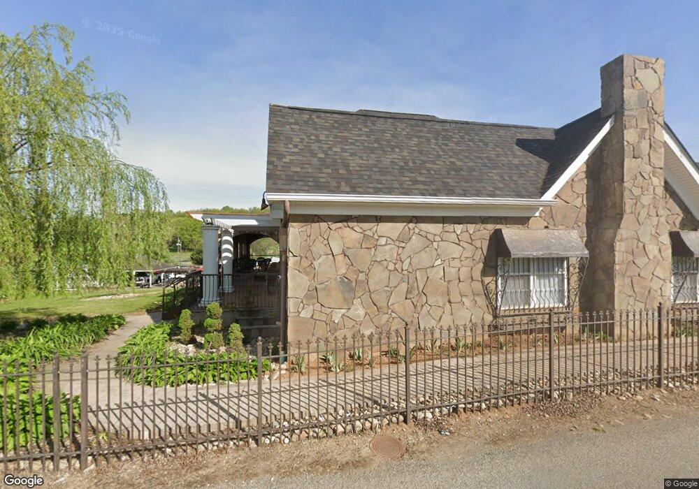
644 Witt Rd Morristown, TN 37813
Estimated Value: $562,294 - $987,000
7
Beds
5
Baths
5,031
Sq Ft
$147/Sq Ft
Est. Value
About This Home
This home is located at 644 Witt Rd, Morristown, TN 37813 and is currently estimated at $740,765, approximately $147 per square foot. 644 Witt Rd is a home located in Hamblen County with nearby schools including Witt Elementary School, Lincoln Heights Middle School, and Morristown West High School.
Ownership History
Date
Name
Owned For
Owner Type
Purchase Details
Closed on
Apr 5, 2024
Sold by
City Of Morristown
Bought by
Soto Cesar and Soto Irma
Current Estimated Value
Purchase Details
Closed on
Aug 16, 2010
Sold by
Community National Bank Of
Bought by
B
Purchase Details
Closed on
Jan 29, 2010
Bought by
Community National Bank Of The Lakeway Area
Purchase Details
Closed on
Aug 14, 2007
Sold by
Lynn Dalton Billy
Bought by
Bowman Mark
Purchase Details
Closed on
Dec 27, 2002
Sold by
Dalton Mariena F
Bought by
Dalton Billy L
Purchase Details
Closed on
Dec 10, 1992
Bought by
Johnson Shirely Ann and Dalton Ronald
Purchase Details
Closed on
Dec 9, 1992
Bought by
Davis Eddie R and Davis Betty K
Purchase Details
Closed on
Nov 12, 1987
Bought by
Davis Eddie R and Davis Betty K
Purchase Details
Closed on
Nov 11, 1987
Bought by
Hollin William B and Hollin Betty J
Purchase Details
Closed on
Feb 12, 1987
Bought by
Hollin William B and Hollin Betty J
Purchase Details
Closed on
Oct 20, 1951
Bought by
Davenport William and Davenport Martha
Create a Home Valuation Report for This Property
The Home Valuation Report is an in-depth analysis detailing your home's value as well as a comparison with similar homes in the area
Home Values in the Area
Average Home Value in this Area
Purchase History
| Date | Buyer | Sale Price | Title Company |
|---|---|---|---|
| Soto Cesar | -- | None Listed On Document | |
| B | $70,500 | -- | |
| Community National Bank Of The Lakeway Area | $357,700 | -- | |
| Bowman Mark | $45,000 | -- | |
| Dalton Billy L | -- | -- | |
| Johnson Shirely Ann | $33,500 | -- | |
| Davis Eddie R | -- | -- | |
| Davis Eddie R | $33,000 | -- | |
| Hollin William B | -- | -- | |
| Hollin William B | $22,800 | -- | |
| Davenport William | -- | -- |
Source: Public Records
Tax History Compared to Growth
Tax History
| Year | Tax Paid | Tax Assessment Tax Assessment Total Assessment is a certain percentage of the fair market value that is determined by local assessors to be the total taxable value of land and additions on the property. | Land | Improvement |
|---|---|---|---|---|
| 2024 | $1,903 | $108,100 | $4,675 | $103,425 |
| 2023 | $1,903 | $108,100 | $0 | $0 |
| 2022 | $3,416 | $108,100 | $4,675 | $103,425 |
| 2021 | $3,416 | $108,100 | $4,675 | $103,425 |
| 2020 | $3,091 | $97,950 | $4,675 | $93,275 |
| 2019 | $2,963 | $87,150 | $4,450 | $82,700 |
| 2018 | $2,745 | $87,150 | $4,450 | $82,700 |
| 2017 | $2,702 | $87,150 | $4,450 | $82,700 |
| 2016 | $2,580 | $87,150 | $4,450 | $82,700 |
| 2015 | $2,400 | $87,150 | $4,450 | $82,700 |
| 2014 | -- | $87,150 | $4,450 | $82,700 |
| 2013 | -- | $12,000 | $0 | $0 |
Source: Public Records
Map
Nearby Homes
- 5474 Saint Paul Rd
- 5056 Spencer Hale Rd
- 3520 Sublett Rd
- 848 Spencer Hale Rd
- 5704 Long Creek Rd
- 1500 S Davy Crockett Pkwy
- 0 Old White Pine Rd
- 453 Statem Gap Rd
- 2262 Fernwood Church Rd
- 4996 Saint Paul Rd
- 3017 Hardy Rd
- 2895 Coffey Rd
- 1163 Nathan Dr
- 1160 Statem Gap Rd
- 1418 Mae Collins Rd
- 4207 Clyde Thomas Rd
- 5262 Buell Chapel Rd
- 5972 Leepers Ferry Rd
- TBD Buell Chapel Rd
- 1051 Wilson Hale Rd