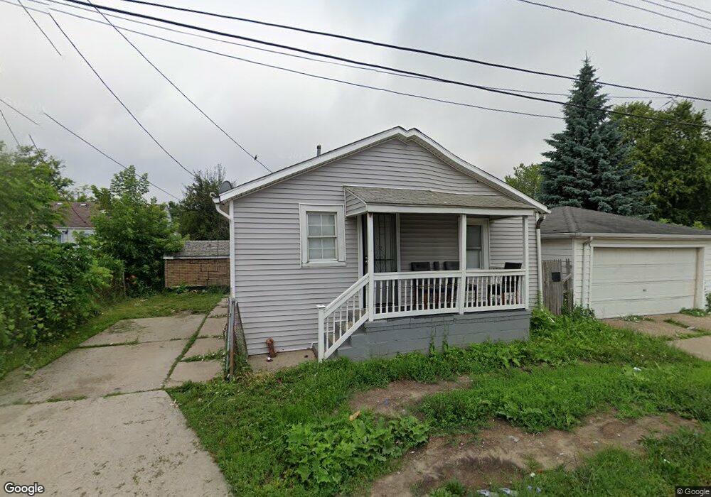
6444 Ashton Ave Detroit, MI 48228
Warrendale NeighborhoodEstimated Value: $61,000 - $100,000
--
Bed
1
Bath
606
Sq Ft
$144/Sq Ft
Est. Value
About This Home
This home is located at 6444 Ashton Ave, Detroit, MI 48228 and is currently estimated at $87,167, approximately $143 per square foot. 6444 Ashton Ave is a home located in Wayne County with nearby schools including Gardner Elementary School, Charles L. Spain Elementary-Middle School, and Edward 'Duke' Ellington Conservatory of Music and Art.
Ownership History
Date
Name
Owned For
Owner Type
Purchase Details
Closed on
May 11, 2023
Sold by
Plata O Plomo Llc
Bought by
Mr Detroit Houses Llc
Current Estimated Value
Purchase Details
Closed on
Feb 17, 2023
Sold by
Wright Anna
Bought by
Plata O Plomo Llc
Purchase Details
Closed on
Aug 26, 2022
Sold by
Stanton Jammie L
Bought by
Cook Martez J and Wright Anna L
Purchase Details
Closed on
Aug 24, 2022
Sold by
Micheal Domman
Bought by
Startor Jammie
Purchase Details
Closed on
Apr 18, 1994
Sold by
Est Stella Walos
Bought by
Michael P and Michael Maryann Domman
Create a Home Valuation Report for This Property
The Home Valuation Report is an in-depth analysis detailing your home's value as well as a comparison with similar homes in the area
Home Values in the Area
Average Home Value in this Area
Purchase History
| Date | Buyer | Sale Price | Title Company |
|---|---|---|---|
| Mr Detroit Houses Llc | -- | None Listed On Document | |
| Plata O Plomo Llc | $12,000 | -- | |
| Cook Martez J | $5,000 | -- | |
| Startor Jammie | -- | -- | |
| Michael P | $15,218 | -- |
Source: Public Records
Tax History Compared to Growth
Tax History
| Year | Tax Paid | Tax Assessment Tax Assessment Total Assessment is a certain percentage of the fair market value that is determined by local assessors to be the total taxable value of land and additions on the property. | Land | Improvement |
|---|---|---|---|---|
| 2025 | $1,177 | $15,100 | $0 | $0 |
| 2024 | $1,177 | $12,300 | $0 | $0 |
| 2023 | $949 | $9,215 | $0 | $0 |
| 2022 | $493 | $7,300 | $0 | $0 |
| 2021 | $485 | $4,760 | $0 | $0 |
| 2020 | $482 | $5,300 | $0 | $0 |
| 2019 | $477 | $4,320 | $0 | $0 |
| 2018 | $434 | $4,400 | $0 | $0 |
| 2017 | $61 | $4,500 | $0 | $0 |
| 2016 | $466 | $3,400 | $0 | $0 |
| 2015 | $340 | $3,400 | $0 | $0 |
| 2013 | $447 | $4,472 | $0 | $0 |
| 2010 | -- | $6,556 | $803 | $5,753 |
Source: Public Records
Map
Nearby Homes
- 6530 Ashton Ave
- 6438 Archdale St
- 6349 Archdale St
- 6508 Penrod St
- 6720 Rosemont Ave
- 6365 Longacre St
- 6390 Faust Ave
- 6235 Ashton Ave
- 6540 Longacre St
- 6235 Rosemont Ave
- 6491 Rutland St
- 6403 Faust Ave
- 6730 Longacre St
- 6545 Rutland St
- 6374 Rutland St
- 6222 Faust Ave
- 6801 Rutland St
- 6360 Brace St
- 6848 Rutland St
- 6354 Stahelin Ave
- 6450 Ashton Ave
- 6434 Ashton Ave
- 6460 Ashton Ave
- 6428 Ashton Ave
- 6466 Ashton Ave
- 6420 Ashton Ave
- 6470 Ashton Ave
- 6476 Ashton Ave
- 6410 Ashton Ave
- 6445 Ashton Ave
- 6445 Ashton Ave
- 6435 Ashton Ave
- 6451 Ashton Ave
- 6429 Ashton Ave
- 6484 Ashton Ave
- 6404 Ashton Ave
- 6421 Ashton Ave
- 6467 Ashton Ave
- 6411 Ashton Ave
- 6490 Ashton Ave