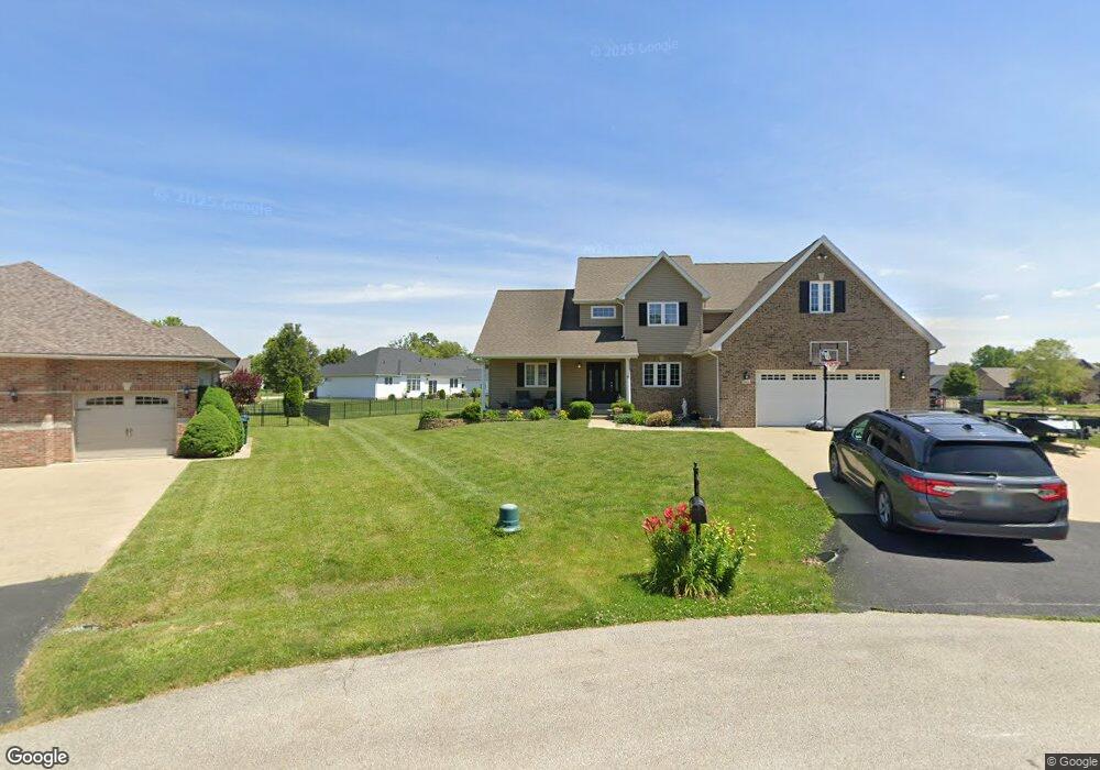
6444 Cypress Ct Decatur, IL 62521
Estimated Value: $394,000 - $503,000
--
Bed
1
Bath
2,150
Sq Ft
$212/Sq Ft
Est. Value
About This Home
This home is located at 6444 Cypress Ct, Decatur, IL 62521 and is currently estimated at $456,108, approximately $212 per square foot. 6444 Cypress Ct is a home located in Macon County with nearby schools including McGaughey Elementary School, Mt. Zion Intermediate School, and Mt. Zion Elementary School.
Ownership History
Date
Name
Owned For
Owner Type
Purchase Details
Closed on
Jun 12, 2015
Sold by
Koshinski Craig and Koshinski Ashley
Bought by
Karasch Joseph P and Karasch Sarah S
Current Estimated Value
Home Financials for this Owner
Home Financials are based on the most recent Mortgage that was taken out on this home.
Original Mortgage
$241,000
Outstanding Balance
$185,992
Interest Rate
3.65%
Mortgage Type
New Conventional
Estimated Equity
$270,116
Purchase Details
Closed on
May 27, 2005
Sold by
Allen Timothy C
Bought by
Watson Mark J and Watson Joanie L
Home Financials for this Owner
Home Financials are based on the most recent Mortgage that was taken out on this home.
Original Mortgage
$243,000
Interest Rate
5.91%
Mortgage Type
New Conventional
Create a Home Valuation Report for This Property
The Home Valuation Report is an in-depth analysis detailing your home's value as well as a comparison with similar homes in the area
Home Values in the Area
Average Home Value in this Area
Purchase History
| Date | Buyer | Sale Price | Title Company |
|---|---|---|---|
| Karasch Joseph P | $325,000 | Macon County Title L L C | |
| Watson Mark J | -- | None Available |
Source: Public Records
Mortgage History
| Date | Status | Borrower | Loan Amount |
|---|---|---|---|
| Open | Karasch Joseph P | $241,000 | |
| Previous Owner | Watson Mark J | $243,000 |
Source: Public Records
Tax History Compared to Growth
Tax History
| Year | Tax Paid | Tax Assessment Tax Assessment Total Assessment is a certain percentage of the fair market value that is determined by local assessors to be the total taxable value of land and additions on the property. | Land | Improvement |
|---|---|---|---|---|
| 2024 | $8,319 | $138,307 | $14,350 | $123,957 |
| 2023 | $8,083 | $128,514 | $13,334 | $115,180 |
| 2022 | $7,606 | $120,836 | $12,538 | $108,298 |
| 2021 | $7,393 | $114,555 | $11,886 | $102,669 |
| 2020 | $7,114 | $109,484 | $11,360 | $98,124 |
| 2019 | $7,114 | $109,484 | $11,360 | $98,124 |
| 2018 | $6,942 | $107,085 | $11,111 | $95,974 |
| 2017 | $6,917 | $105,763 | $10,974 | $94,789 |
| 2016 | $6,317 | $97,087 | $10,967 | $86,120 |
| 2015 | $6,114 | $95,841 | $10,826 | $85,015 |
| 2014 | $5,935 | $95,841 | $10,826 | $85,015 |
| 2013 | -- | $95,841 | $10,826 | $85,015 |
Source: Public Records
Map
Nearby Homes
- 6455 Birchwood Ln
- 6525 Majors Ln
- 2615 French Dr
- 2670 Jennifer Dr
- 5620 E Firehouse Rd
- 1910 Marca St
- 5715 Ocean Trail
- 3930 S Mount Zion Rd
- 1440 N Alexander Dr
- 4140 Fort Daniel Rd
- 6680 John Dr
- Lot 31 Woodbine Park Prairie Estates
- Lot 32 Janine Way
- 574 N Antler Dr
- Lot 1 Fletcher Ln
- Lot 2 Fletcher Ln
- Lot 3 Fletcher Ln
- 570 Fawn Ct
- Lot 27 Tara Way
- Lot 20 Jeffrey Dr
- 6441 Cedar Crest Ct
- 6448 Cypress Ct
- 6424 Cypress Ct
- 6520 Daybrook Dr
- 6431 Cedar Crest Ct
- 6536 Daybrook Dr
- 6508 Daybrook Dr
- 6443 Cypress Ct
- 6448 Cedar Crest Ct
- 6414 Cypress Ct
- 6423 Cypress Ct
- 6521 Daybrook Dr
- 6535 Daybrook Dr
- 6552 Daybrook Dr
- 6413 Cypress Ct
- 6509 Daybrook Dr
- 6411 Cedar Crest Ct
- 6501 Daybrook Dr
- 6442 Cedar Crest Ct
- 6432 Cedar Crest Ct