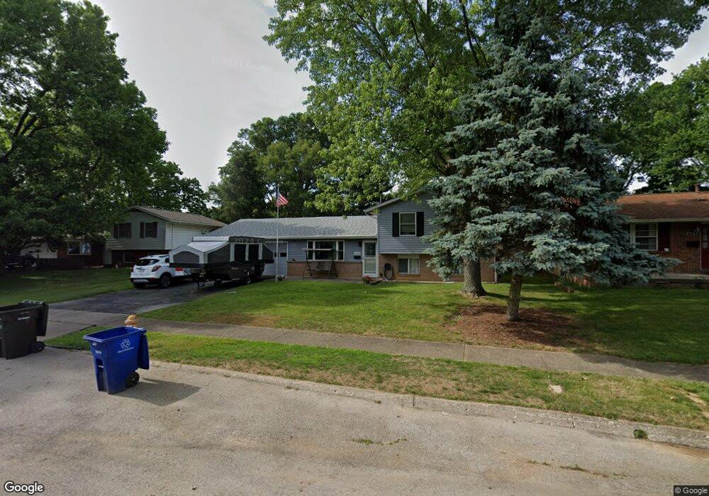
6448 Kings Charter Rd Reynoldsburg, OH 43068
Glenmeadows NeighborhoodEstimated Value: $244,000 - $264,000
4
Beds
2
Baths
1,416
Sq Ft
$180/Sq Ft
Est. Value
About This Home
This home is located at 6448 Kings Charter Rd, Reynoldsburg, OH 43068 and is currently estimated at $254,609, approximately $179 per square foot. 6448 Kings Charter Rd is a home located in Franklin County with nearby schools including Rose Hill Elementary School, Waggoner Road Elementary School, and Waggoner Road Junior High School.
Ownership History
Date
Name
Owned For
Owner Type
Purchase Details
Closed on
Jul 29, 2024
Sold by
Holland Jeffery R
Bought by
Holland Jeffery R and Holland Kathi A
Current Estimated Value
Purchase Details
Closed on
May 22, 1998
Sold by
Lebold Samuel K and Lebold Jean L
Bought by
Holland Jeffery R
Purchase Details
Closed on
Aug 1, 1983
Create a Home Valuation Report for This Property
The Home Valuation Report is an in-depth analysis detailing your home's value as well as a comparison with similar homes in the area
Home Values in the Area
Average Home Value in this Area
Purchase History
| Date | Buyer | Sale Price | Title Company |
|---|---|---|---|
| Holland Jeffery R | -- | None Listed On Document | |
| Holland Jeffery R | $95,000 | Foundation Title Agency Inc | |
| -- | $60,000 | -- |
Source: Public Records
Tax History Compared to Growth
Tax History
| Year | Tax Paid | Tax Assessment Tax Assessment Total Assessment is a certain percentage of the fair market value that is determined by local assessors to be the total taxable value of land and additions on the property. | Land | Improvement |
|---|---|---|---|---|
| 2024 | $2,833 | $69,550 | $18,550 | $51,000 |
| 2023 | $2,789 | $69,545 | $18,550 | $50,995 |
| 2022 | $2,356 | $46,240 | $16,800 | $29,440 |
| 2021 | $2,363 | $46,240 | $16,800 | $29,440 |
| 2020 | $2,389 | $46,240 | $16,800 | $29,440 |
| 2019 | $2,288 | $38,500 | $14,000 | $24,500 |
| 2018 | $2,293 | $38,500 | $14,000 | $24,500 |
| 2017 | $2,294 | $38,500 | $14,000 | $24,500 |
| 2016 | $2,300 | $34,660 | $9,000 | $25,660 |
| 2015 | $2,299 | $34,660 | $9,000 | $25,660 |
| 2014 | $2,312 | $34,660 | $9,000 | $25,660 |
| 2013 | $1,183 | $36,505 | $9,485 | $27,020 |
Source: Public Records
Map
Nearby Homes
- 6442 Borr Ave
- 6526 Borr Ave
- 6535 Red Fox Rd
- 6564 Red Fox Rd
- 6600 Carriage Ln
- 6599 Carriage Ln
- 6568 Shenandoah Dr
- 6563 Helm Ave
- 0 Rosehill Rd
- 6231 Peach Tree Rd
- 6737 Rocky Den Rd
- 622 Brice Rd
- 6810 Prior Place
- 6700 Helm Ln
- 1177 Matterhorn Dr
- 6279 Braiden Ct Unit 10B
- 6849 Roundelay Rd N
- 6207 Roxburgh Ct Unit 16D
- 6890 Nocturne Rd N
- 557 Woodingham Place Unit 1A
- 6456 Kings Charter Rd
- 6440 Kings Charter Rd
- 6464 Kings Charter Rd
- 6457 Borr Ave
- 6465 Borr Ave
- 6447 Borr Ave
- 945 Sutton Place
- 6441 Borr Ave
- 6472 Kings Charter Rd
- 960 Sutton Place
- 6457 Kings Charter Rd
- 953 Sutton Place
- 6483 Borr Ave
- 6433 Borr Ave
- 6465 Kings Charter Rd
- 6480 Kings Charter Rd
- 961 Sutton Place
- 6491 Borr Ave
- 6425 Borr Ave
- 6473 Kings Charter Rd