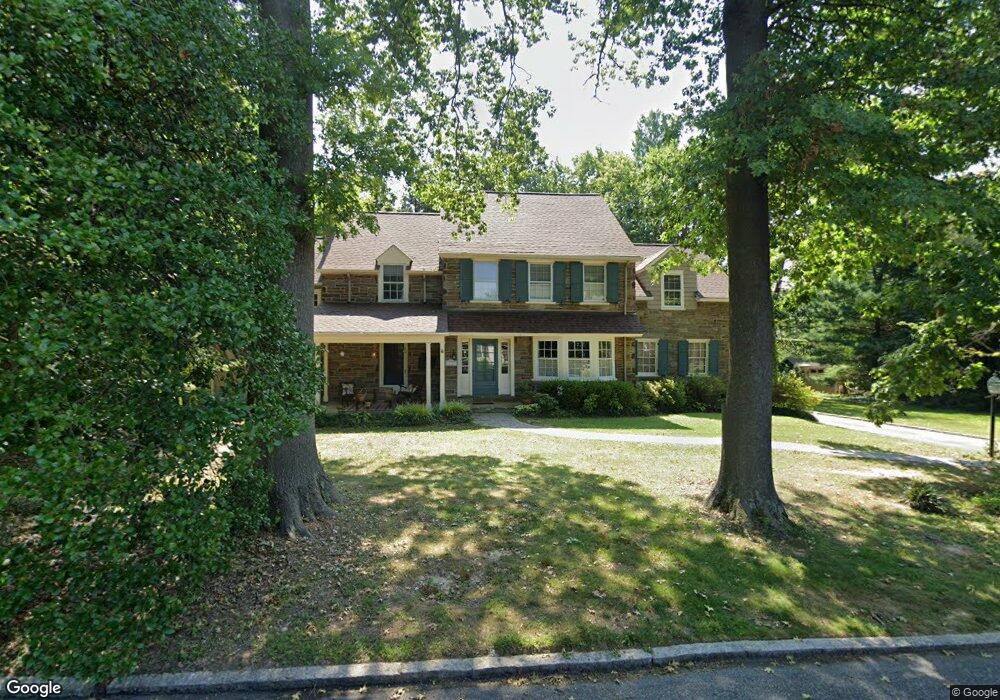
645 Parrish Rd Swarthmore, PA 19081
Estimated Value: $989,000 - $1,109,066
4
Beds
4
Baths
3,354
Sq Ft
$310/Sq Ft
Est. Value
About This Home
This home is located at 645 Parrish Rd, Swarthmore, PA 19081 and is currently estimated at $1,040,517, approximately $310 per square foot. 645 Parrish Rd is a home located in Delaware County with nearby schools including Swarthmore-Rutledge School, Strath Haven Middle School, and Strath Haven High School.
Ownership History
Date
Name
Owned For
Owner Type
Purchase Details
Closed on
Jul 16, 2025
Sold by
Silverstein Kenneth Lee and Silverstein Julie Harris
Bought by
Silverstein Julie Harris
Current Estimated Value
Purchase Details
Closed on
Jun 15, 1990
Sold by
Carpenter John M and Carpenter Gloria K
Bought by
Silverstein Kenneth L and Silverstein Julie H
Create a Home Valuation Report for This Property
The Home Valuation Report is an in-depth analysis detailing your home's value as well as a comparison with similar homes in the area
Home Values in the Area
Average Home Value in this Area
Purchase History
| Date | Buyer | Sale Price | Title Company |
|---|---|---|---|
| Silverstein Julie Harris | -- | None Listed On Document | |
| Silverstein Julie Harris | -- | None Listed On Document | |
| Silverstein Kenneth L | $369,000 | -- |
Source: Public Records
Tax History
| Year | Tax Paid | Tax Assessment Tax Assessment Total Assessment is a certain percentage of the fair market value that is determined by local assessors to be the total taxable value of land and additions on the property. | Land | Improvement |
|---|---|---|---|---|
| 2025 | $21,747 | $603,480 | $160,960 | $442,520 |
| 2024 | $21,747 | $603,480 | $160,960 | $442,520 |
| 2023 | $20,905 | $603,480 | $160,960 | $442,520 |
| 2022 | $20,351 | $603,480 | $160,960 | $442,520 |
| 2021 | $33,147 | $603,480 | $160,960 | $442,520 |
| 2020 | $17,937 | $307,450 | $120,020 | $187,430 |
| 2019 | $17,485 | $307,450 | $120,020 | $187,430 |
| 2018 | $17,197 | $307,450 | $0 | $0 |
| 2017 | $16,810 | $307,450 | $0 | $0 |
| 2016 | $1,687 | $307,450 | $0 | $0 |
| 2015 | $1,687 | $307,450 | $0 | $0 |
| 2014 | $1,687 | $307,450 | $0 | $0 |
Source: Public Records
Map
Nearby Homes
- 519 Walnut Ln Unit 1
- 1588 Nicklaus Dr Unit H65
- 1433 Country Club Dr Unit T214
- 1299 Country Club Dr Unit Q141
- 1291 Country Club Dr Unit Q137
- 131 Dartmouth Ave
- 493 Wheatsheaf Rd
- 110 Park Ave Unit 370
- 110 Park Ave Unit 350
- 110 Park Ave Unit 250
- 110 Park Ave Unit 320
- 110 Park Ave Unit 220
- 110 Park Ave Unit 430
- 110 Park Ave Unit 340
- 411 Marie Dr
- 339 Plush Mill Rd
- 603 Harvard Ave
- 364 S Rolling Rd
- 246 Pennington Ave
- 31 Wayfield Rd
- 615 Parrish Rd
- 635 Parrish Rd
- 655 Parrish Rd
- 664 Parrish Rd
- 622 N Chester Rd
- 624 N Chester Rd
- 620 N Chester Rd
- 660 Parrish Rd
- 631 Parrish Rd
- 618 N Chester Rd
- 668 Parrish Rd
- 629 Magill Rd
- 640 Magill Rd
- 630 N Chester Rd
- 669 Parrish Rd
- 650 Parrish Rd
- 636 Magill Rd
- 612 N Chester Rd
- 625 Magill Rd
- 625 Parrish Rd
Your Personal Tour Guide
Ask me questions while you tour the home.