Estimated Value: $179,000 - $237,000
2
Beds
1
Bath
819
Sq Ft
$264/Sq Ft
Est. Value
About This Home
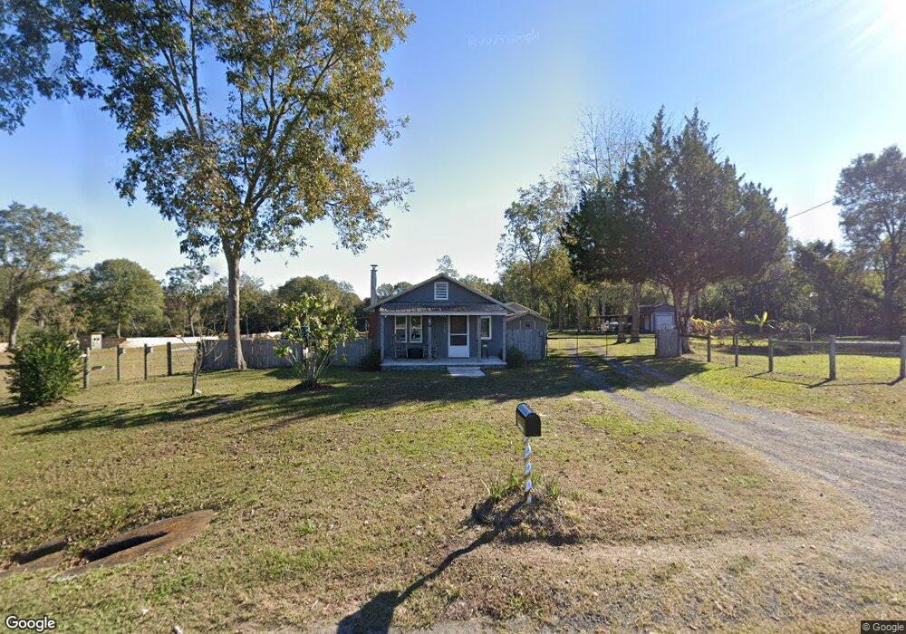
This home is located at 6455 Highway 189 N, Baker, FL 32531 and is currently estimated at $216,595, approximately $264 per square foot. 6455 Highway 189 N is a home located in Okaloosa County with nearby schools including Baker School.
Ownership History
Date
Name
Owned For
Owner Type
Purchase Details
Closed on
Dec 22, 2017
Sold by
Barnhill Nathan Louie
Bought by
Barnhill Blake K
Current Estimated Value
Purchase Details
Closed on
Jul 5, 2016
Sold by
Phillips Wanda E and Smith Wanda Smith
Bought by
Barnhill Blake K
Home Financials for this Owner
Home Financials are based on the most recent Mortgage that was taken out on this home.
Original Mortgage
$55,000
Outstanding Balance
$44,121
Interest Rate
3.48%
Estimated Equity
$172,474
Purchase Details
Closed on
Apr 2, 2014
Sold by
Barnhill Nathan Louie
Bought by
Barnhill Brandon K and Barnhill Blake K
Create a Home Valuation Report for This Property
The Home Valuation Report is an in-depth analysis detailing your home's value as well as a comparison with similar homes in the area
Home Values in the Area
Average Home Value in this Area
Purchase History
| Date | Buyer | Sale Price | Title Company |
|---|---|---|---|
| Barnhill Blake K | -- | Attorney | |
| Barnhill Blake K | $55,000 | -- | |
| Barnhill Brandon K | -- | Attorney |
Source: Public Records
Mortgage History
| Date | Status | Borrower | Loan Amount |
|---|---|---|---|
| Open | Barnhill Blake K | $24,000 | |
| Open | Barnhill Blake K | $55,000 | |
| Closed | Barnhill Blake K | -- |
Source: Public Records
Tax History Compared to Growth
Tax History
| Year | Tax Paid | Tax Assessment Tax Assessment Total Assessment is a certain percentage of the fair market value that is determined by local assessors to be the total taxable value of land and additions on the property. | Land | Improvement |
|---|---|---|---|---|
| 2024 | $640 | $94,179 | -- | -- |
| 2023 | $640 | $91,436 | $0 | $0 |
| 2022 | $621 | $88,773 | $0 | $0 |
| 2021 | $612 | $86,187 | $0 | $0 |
| 2020 | $600 | $84,997 | $62,700 | $22,297 |
| 2019 | $586 | $83,538 | $62,700 | $20,838 |
| 2018 | $953 | $82,582 | $0 | $0 |
| 2017 | $954 | $81,268 | $0 | $0 |
| 2016 | $939 | $80,792 | $0 | $0 |
| 2015 | $960 | $80,191 | $0 | $0 |
| 2014 | $1,004 | $83,216 | $0 | $0 |
Source: Public Records
Map
Nearby Homes
- 1318 John Riley Barnhill Rd
- 1512 Vinson Ray Rd
- 0000 N Sherman Kennedy
- 0 Homestead Rd
- 1704 Cobb Rd
- 6043 Dairy Rd
- 6636 Old River Rd
- 16 acres Sherman Kennedy Rd
- 0000 Sherman Kennedy Rd
- 1424 E F Sanford Rd
- 6150 Sherman Kennedy Rd
- F-10 Long Branch Farm Rd
- F-9 Long Branch Farm Rd
- F-8 Long Branch Farms Rd
- 924 Hwy C4a
- 1921 Cotton Creek Rd
- F-3 Long Branch Farm Rd
- 5994 Highway 4 W
- 6224 Old River Rd
- A-1 Long Branch Farm Rd
- 6467 Highway 189 N
- 6449 Highway 189 N
- 6477 Highway 189 N
- 6448 Highway 189 N
- 6443 Highway 189 N
- 6496 Florida 189
- 6496 Highway 189 N
- 6549 William Gary Johnson Rd
- 6501 Highway 189 N
- 1422 Dan Barnes Rd
- 6506 Highway 189 N
- 6433 Hwy 189 N
- 6543 William Gary Johnson Rd
- 6535 William Gary Johnson Rd
- 1423 Dan Barnes Rd
- 1425 Dan Barnes Rd
- 6515 Highway 189 N
- 1450 Dan Barnes Rd
- 1454 Sky Ranch Dr
- 1443 Dan Barnes Rd