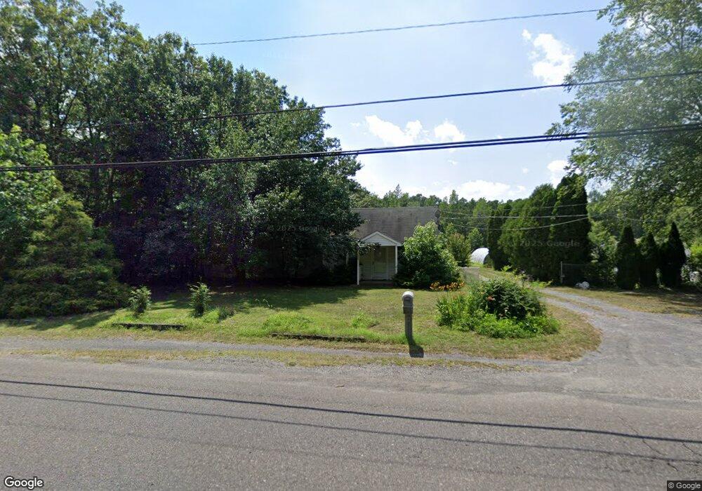
6456 Weymouth Rd Mays Landing, NJ 08330
Estimated Value: $298,000 - $439,000
--
Bed
--
Bath
1,142
Sq Ft
$327/Sq Ft
Est. Value
About This Home
This home is located at 6456 Weymouth Rd, Mays Landing, NJ 08330 and is currently estimated at $373,021, approximately $326 per square foot. 6456 Weymouth Rd is a home located in Atlantic County with nearby schools including Joseph Shaner School, George L. Hess Educational Complex, and William Davies Middle School.
Ownership History
Date
Name
Owned For
Owner Type
Purchase Details
Closed on
May 6, 2005
Sold by
Biggs Helen
Bought by
Defeo Alfred Frank
Current Estimated Value
Home Financials for this Owner
Home Financials are based on the most recent Mortgage that was taken out on this home.
Original Mortgage
$79,000
Outstanding Balance
$41,720
Interest Rate
5.94%
Mortgage Type
Credit Line Revolving
Estimated Equity
$331,302
Purchase Details
Closed on
Jan 28, 1999
Sold by
Herbert Nancy E
Bought by
Biggs Helen
Create a Home Valuation Report for This Property
The Home Valuation Report is an in-depth analysis detailing your home's value as well as a comparison with similar homes in the area
Home Values in the Area
Average Home Value in this Area
Purchase History
| Date | Buyer | Sale Price | Title Company |
|---|---|---|---|
| Defeo Alfred Frank | $300,000 | Commonwealth Land Title Insu | |
| Biggs Helen | $82,500 | Commonwealth Land Title Ins |
Source: Public Records
Mortgage History
| Date | Status | Borrower | Loan Amount |
|---|---|---|---|
| Open | Defeo Alfred Frank | $79,000 | |
| Open | Defeo Alfred Frank | $150,000 |
Source: Public Records
Tax History Compared to Growth
Tax History
| Year | Tax Paid | Tax Assessment Tax Assessment Total Assessment is a certain percentage of the fair market value that is determined by local assessors to be the total taxable value of land and additions on the property. | Land | Improvement |
|---|---|---|---|---|
| 2025 | $3,980 | $116,000 | $50,600 | $65,400 |
| 2024 | $3,980 | $116,000 | $50,600 | $65,400 |
| 2023 | $3,492 | $116,000 | $50,600 | $65,400 |
| 2022 | $3,742 | $116,000 | $50,600 | $65,400 |
| 2021 | $3,484 | $116,000 | $50,600 | $65,400 |
| 2020 | $3,484 | $116,000 | $50,600 | $65,400 |
| 2019 | $3,493 | $116,000 | $50,600 | $65,400 |
| 2018 | $3,362 | $116,000 | $50,600 | $65,400 |
| 2017 | $3,305 | $116,000 | $50,600 | $65,400 |
| 2016 | $3,206 | $116,000 | $50,600 | $65,400 |
| 2015 | $3,088 | $116,000 | $50,600 | $65,400 |
| 2014 | $3,141 | $129,100 | $59,000 | $70,100 |
Source: Public Records
Map
Nearby Homes
- 850 Morningside Dr
- Rt 50 and Old Mays Landing Rd
- 6301 Knight Ave
- 6310 Phillips Ave
- 6206 Roberts Ave
- 6314 Lance Ave
- 6302 Palmer Ave
- 6251 Old Harding Hwy
- 565 Park Rd
- 80 Mill St
- 535 Park Rd
- 0 Harding Hwy Unit 597638
- 0 Harding Hwy Unit NJAC2019438
- 1st First Ave
- Lot:11.02-12.02 Estelle Ave
- B:534 L:11.01 Estelle Ave
- B:534 L:12.02 Estelle Ave
- B:534 L:11.02 Estelle Ave
- 526 Bainbridge Ave
- Bl 531 Lot 8&9 Adams Ave
- 6489 Weymouth Rd
- 6520 Weymouth Rd
- 6521 Weymouth Rd
- 6538 Weymouth Rd
- 1512 Benjamin Franklin Ct
- 6531 Weymouth Rd
- 6541 Weymouth Rd
- 6551 Weymouth Rd
- 1069 Morningside Dr
- 1085 Morningside Dr
- 1037 Morningside Dr
- 1053 Morningside Dr
- 1017 Morningside Dr
- 1029 Morningside Dr
- 1005 Morningside Dr
- 997 Morningside Dr
- 973 Morningside Dr
- 1024 Morningside Dr
- 985 Morningside Dr
- 1016 Morningside Dr