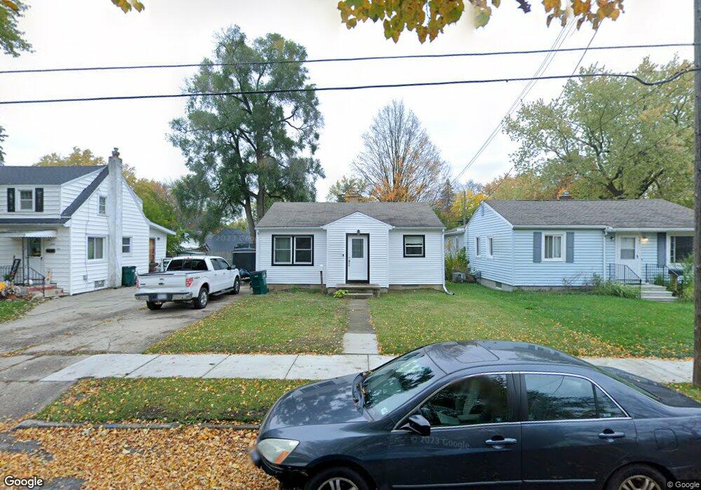
647 E Willard Ave Lansing, MI 48910
Old Everett NeighborhoodEstimated Value: $100,116 - $124,000
Studio
--
Bath
816
Sq Ft
$140/Sq Ft
Est. Value
About This Home
This home is located at 647 E Willard Ave, Lansing, MI 48910 and is currently estimated at $114,529, approximately $140 per square foot. 647 E Willard Ave is a home located in Ingham County with nearby schools including Lyons Elementary School, Attwood School, and Everett High School.
Ownership History
Date
Name
Owned For
Owner Type
Purchase Details
Closed on
Aug 7, 2012
Sold by
Logan Nancy J
Bought by
Logan Nancy J
Current Estimated Value
Purchase Details
Closed on
Jul 24, 2009
Sold by
Anderson Bart and Anderson Brad
Bought by
Logan Nancy
Purchase Details
Closed on
Mar 12, 2007
Sold by
Anderson Eugene V
Bought by
Anderson Sophia M
Purchase Details
Closed on
Oct 10, 1990
Sold by
Anderson Sophia M
Bought by
Logan Logan N and Logan Anderson E
Create a Home Valuation Report for This Property
The Home Valuation Report is an in-depth analysis detailing your home's value as well as a comparison with similar homes in the area
Home Values in the Area
Average Home Value in this Area
Purchase History
| Date | Buyer | Sale Price | Title Company |
|---|---|---|---|
| Logan Nancy J | -- | None Available | |
| Logan Nancy | -- | None Available | |
| Anderson Sophia M | -- | None Available | |
| Logan Logan N | -- | -- |
Source: Public Records
Tax History
| Year | Tax Paid | Tax Assessment Tax Assessment Total Assessment is a certain percentage of the fair market value that is determined by local assessors to be the total taxable value of land and additions on the property. | Land | Improvement |
|---|---|---|---|---|
| 2025 | $2,037 | $48,900 | $6,400 | $42,500 |
| 2024 | $16 | $44,300 | $6,400 | $37,900 |
| 2023 | $1,912 | $40,500 | $6,400 | $34,100 |
| 2022 | $1,727 | $34,700 | $5,900 | $28,800 |
| 2021 | $1,691 | $32,200 | $3,800 | $28,400 |
| 2020 | $1,680 | $30,800 | $3,800 | $27,000 |
| 2019 | $1,609 | $26,800 | $3,800 | $23,000 |
| 2018 | $1,510 | $24,600 | $3,800 | $20,800 |
| 2017 | $1,446 | $24,600 | $3,800 | $20,800 |
| 2016 | $1,728 | $24,200 | $3,800 | $20,400 |
| 2015 | $1,728 | $23,000 | $7,684 | $15,316 |
| 2014 | $1,728 | $22,700 | $5,977 | $16,723 |
Source: Public Records
Map
Nearby Homes
- 3101 Plymouth Dr
- 915 Tisdale Ave
- 2340 S Pennsylvania Ave
- 413 E Hodge Ave
- 2208 Lyons Ave
- 320 E Hodge Ave
- 2201 S Pennsylvania Ave
- 2215 Alpha St
- 704 Mckim Ave
- 2302 Maplewood Ave
- 2418 Forest Ave
- 2305 Forest Ave
- 3319 Jewell Ave
- 3603 Parkway Dr
- 616 Glendale Ave
- 525 E Mount Hope Ave
- 215 Dunlap St
- 1818 Ray St
- 2237 Sunnyside Ave
- 1917 Teel Ave
- 641 E Willard Ave
- 707 E Willard Ave
- 637 E Willard Ave
- 644 Park Blvd
- 640 Park Blvd
- 640 S Park Blvd
- 711 E Willard Ave
- 633 E Willard Ave
- 706 Park Blvd
- 636 Park Blvd
- 644 E Willard Ave
- 640 E Willard Ave
- 700 E Willard Ave
- 706 S Park Blvd
- 632 S Park Blvd
- 710 Park Blvd
- 629 E Willard Ave
- 636 E Willard Ave
- 704 E Willard Ave