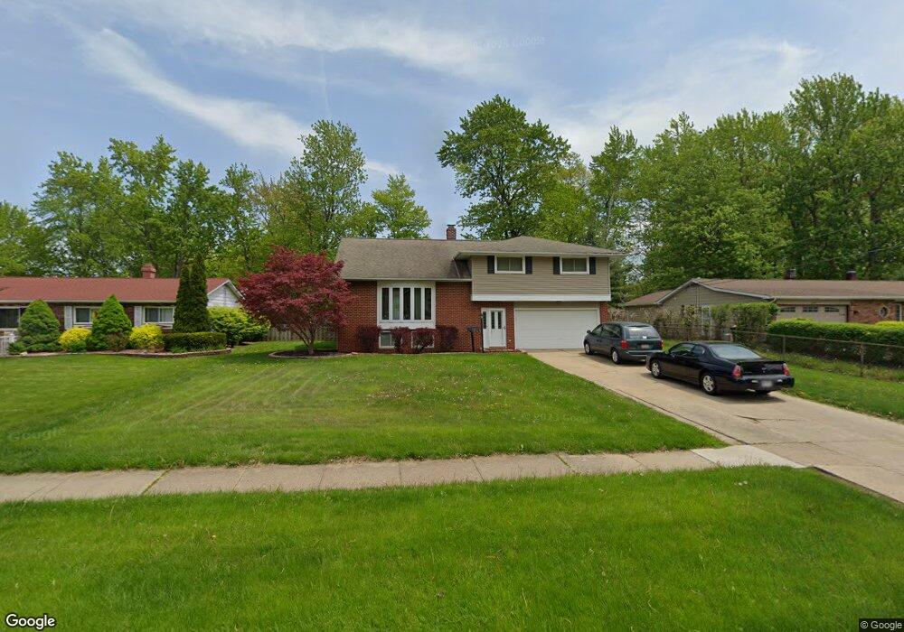
6475 Melshore Dr Mentor, OH 44060
Estimated Value: $316,929 - $373,000
4
Beds
3
Baths
2,208
Sq Ft
$152/Sq Ft
Est. Value
About This Home
This home is located at 6475 Melshore Dr, Mentor, OH 44060 and is currently estimated at $335,732, approximately $152 per square foot. 6475 Melshore Dr is a home located in Lake County with nearby schools including Fairfax Elementary School, Memorial Middle School, and Mentor High School.
Ownership History
Date
Name
Owned For
Owner Type
Purchase Details
Closed on
Feb 12, 2005
Sold by
Hupp Craig A and Schwertner Hupp Christine
Bought by
Mason Robert L and Mason Connie M
Current Estimated Value
Home Financials for this Owner
Home Financials are based on the most recent Mortgage that was taken out on this home.
Original Mortgage
$207,000
Outstanding Balance
$103,644
Interest Rate
5.83%
Mortgage Type
VA
Estimated Equity
$232,088
Purchase Details
Closed on
Mar 30, 2004
Sold by
Hupp Craig A and Hupp Christine Schwertner
Bought by
Hupp Craig A and Hupp Christine Schwertner
Purchase Details
Closed on
Nov 27, 1999
Sold by
Hupp Diane J
Bought by
Hupp Craig A
Purchase Details
Closed on
May 7, 1993
Bought by
Hupp Craig A
Create a Home Valuation Report for This Property
The Home Valuation Report is an in-depth analysis detailing your home's value as well as a comparison with similar homes in the area
Home Values in the Area
Average Home Value in this Area
Purchase History
| Date | Buyer | Sale Price | Title Company |
|---|---|---|---|
| Mason Robert L | $227,000 | Enterprise Title | |
| Hupp Craig A | -- | -- | |
| Hupp Craig A | -- | Enterprise Title Agency Inc | |
| Hupp Craig A | $123,000 | -- |
Source: Public Records
Mortgage History
| Date | Status | Borrower | Loan Amount |
|---|---|---|---|
| Open | Mason Robert L | $207,000 |
Source: Public Records
Tax History Compared to Growth
Tax History
| Year | Tax Paid | Tax Assessment Tax Assessment Total Assessment is a certain percentage of the fair market value that is determined by local assessors to be the total taxable value of land and additions on the property. | Land | Improvement |
|---|---|---|---|---|
| 2025 | -- | $103,380 | $26,800 | $76,580 |
| 2024 | -- | $103,380 | $26,800 | $76,580 |
| 2023 | $8,125 | $78,190 | $18,970 | $59,220 |
| 2022 | $2,796 | $78,190 | $18,970 | $59,220 |
| 2021 | $2,804 | $78,190 | $18,970 | $59,220 |
| 2020 | $2,569 | $66,260 | $16,070 | $50,190 |
| 2019 | $2,667 | $66,260 | $16,070 | $50,190 |
| 2018 | $2,659 | $62,010 | $19,380 | $42,630 |
| 2017 | $2,554 | $62,010 | $19,380 | $42,630 |
| 2016 | $2,445 | $62,010 | $19,380 | $42,630 |
| 2015 | $2,570 | $62,010 | $19,380 | $42,630 |
| 2014 | $2,419 | $58,140 | $19,380 | $38,760 |
| 2013 | $2,422 | $58,140 | $19,380 | $38,760 |
Source: Public Records
Map
Nearby Homes
- 6484 Elmwood Rd
- 6595 Devonshire Ct
- 6270 Cumberland Dr
- 8067 Independence Dr Unit D
- 6289 Mentor Park Blvd
- 8140 Independence Dr Unit C
- 8109 Puritan Dr Unit A
- 6824 Kirkwood Dr Unit 8
- 6814 Beacon Dr
- 7961 Independence Dr Unit D
- 8285 Munson Rd
- 8078 Puritan Dr Unit 58-D
- 7992 Puritan Dr Unit 76-C
- 6067 Collins Rd
- 8352 Quail Point Ln Unit 8352
- 8420 Bartley Ln Unit C
- 6883 Colonial Dr Unit B
- 6452 Brooks Blvd
- 0 Collins Rd
- 7671 Aster Dr
- 6467 Melshore Dr
- 6489 Melshore Dr
- 6459 Melshore Dr
- 6495 Melshore Dr
- 8088 Meadowdale Dr
- 6453 Melshore Dr
- 6503 Melshore Dr
- 6456 Curtiss Ct
- 8080 Meadowdale Dr
- 6464 Curtiss Ct
- 6490 Melshore Dr
- 6445 Melshore Dr
- 6511 Melshore Dr
- 6450 Curtiss Ct
- 6498 Melshore Dr
- 8072 Meadowdale Dr
- 6437 Melshore Dr
- 6517 Melshore Dr
- 8089 Meadowdale Dr
- 6502 Melshore Dr