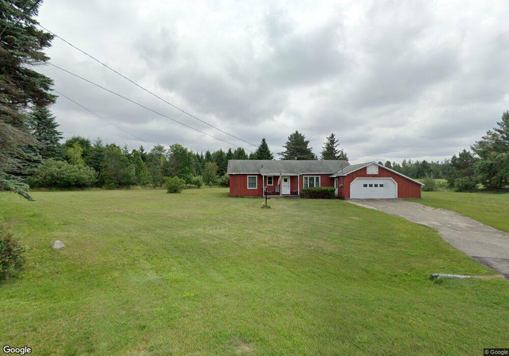
648 Snow Apple Ct Cheboygan, MI 49721
Estimated Value: $121,000 - $218,000
--
Bed
--
Bath
--
Sq Ft
0.4
Acres
About This Home
This home is located at 648 Snow Apple Ct, Cheboygan, MI 49721 and is currently estimated at $174,744. 648 Snow Apple Ct is a home located in Cheboygan County with nearby schools including East Elementary School, Cheboygan Intermediate School, and Cheboygan Area High School.
Ownership History
Date
Name
Owned For
Owner Type
Purchase Details
Closed on
May 2, 2025
Sold by
Pendry Neil G
Bought by
Buhr Cathleen D
Current Estimated Value
Home Financials for this Owner
Home Financials are based on the most recent Mortgage that was taken out on this home.
Original Mortgage
$104,000
Outstanding Balance
$103,631
Interest Rate
6.64%
Mortgage Type
New Conventional
Estimated Equity
$71,113
Purchase Details
Closed on
May 22, 2024
Sold by
Pendry Kathryn M
Bought by
Pendry Neil G and Pendry Kathryn M
Home Financials for this Owner
Home Financials are based on the most recent Mortgage that was taken out on this home.
Original Mortgage
$76,000
Interest Rate
7.17%
Mortgage Type
New Conventional
Create a Home Valuation Report for This Property
The Home Valuation Report is an in-depth analysis detailing your home's value as well as a comparison with similar homes in the area
Home Values in the Area
Average Home Value in this Area
Purchase History
| Date | Buyer | Sale Price | Title Company |
|---|---|---|---|
| Buhr Cathleen D | $130,000 | -- | |
| Pendry Neil G | -- | -- | |
| Pendry Kathryn M | $72,307 | -- | |
| Pendry Kathryn M | -- | -- |
Source: Public Records
Mortgage History
| Date | Status | Borrower | Loan Amount |
|---|---|---|---|
| Open | Buhr Cathleen D | $104,000 | |
| Previous Owner | Pendry Kathryn M | $76,000 |
Source: Public Records
Tax History Compared to Growth
Tax History
| Year | Tax Paid | Tax Assessment Tax Assessment Total Assessment is a certain percentage of the fair market value that is determined by local assessors to be the total taxable value of land and additions on the property. | Land | Improvement |
|---|---|---|---|---|
| 2025 | $998 | $81,900 | $0 | $0 |
| 2024 | $685 | $77,500 | $0 | $0 |
| 2023 | $656 | $69,800 | $0 | $0 |
| 2022 | $636 | $58,088 | $0 | $0 |
| 2021 | $904 | $49,200 | $49,200 | $0 |
| 2020 | $891 | $47,500 | $47,500 | $0 |
| 2019 | $865 | $45,200 | $45,200 | $0 |
| 2018 | $846 | $41,900 | $0 | $0 |
| 2017 | $796 | $41,300 | $0 | $0 |
| 2016 | $783 | $41,800 | $0 | $0 |
| 2015 | -- | $42,200 | $0 | $0 |
| 2014 | -- | $39,800 | $0 | $0 |
| 2012 | -- | $36,700 | $0 | $0 |
Source: Public Records
Map
Nearby Homes
- 444 Riverside Dr
- V/L 33AC Moonlight Bay Rd
- 1357 Sharon Ln
- 9840 N Straits Hwy
- V/L 2.70AC N Straits Hwy
- 10898 N Black River Rd
- 178 Riverside Dr
- 10901 N Black River Rd
- 501 Obrien Dr
- 172 E Lincoln Ave
- 100 Woodland Ct
- 912 S Huron St
- 10480 N Straits Hwy
- 506 Stempky St
- 0 Townline Rd Unit 201816742
- 10351 N Straits Hwy
- V/L 55-+AC E State St
- 303 S C St
- 208 S D St
- 115 S D St
- 647 Snow Apple Ct
- 635 Snow Apple Ct
- 628 Snow Apple Ct
- 629 Snow Apple Ct
- 620 Snow Apple Ct
- 621 Snow Apple Ct
- 621 Snow Apple Ct
- 618 Snow Apple Ct
- 619 Snow Apple Ct
- 7155 McDonald Rd Unit (Pt of Gov't Lot 2)
- 00 McDonald Rd
- 0 McDonald Rd Unit 299683
- 0 McDonald Rd Unit 291530
- 0 McDonald Rd Unit 310139
- 0 McDonald Rd Unit 306544
- 0 McDonald Rd Unit 10 acres 317812
- 0 McDonald Rd Unit Parcel A 306592
- 0 McDonald Rd Unit Parcel B 306595
- 0 McDonald Rd Unit 10 acres 306341
- 0 McDonald Rd Unit 289937