Estimated Value: $341,456 - $375,000
4
Beds
2
Baths
1,833
Sq Ft
$193/Sq Ft
Est. Value
About This Home
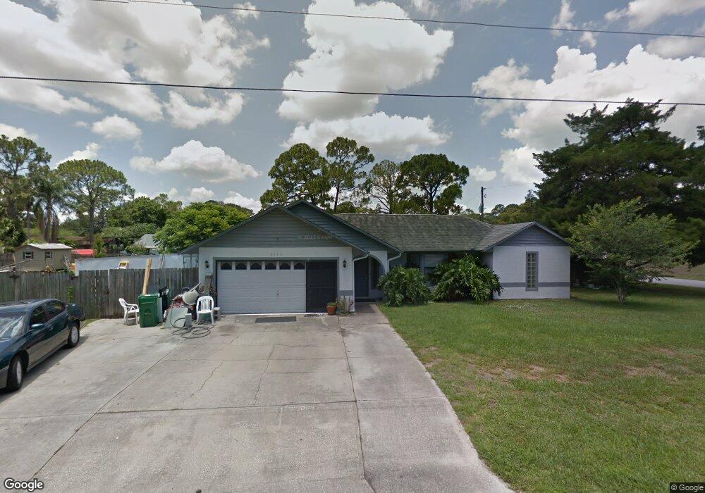
This home is located at 6490 Fairchild Ave, Cocoa, FL 32927 and is currently estimated at $354,364, approximately $193 per square foot. 6490 Fairchild Ave is a home located in Brevard County with nearby schools including Enterprise Elementary School, Space Coast Junior/Senior High School, and East Atlantic Prep of Brevard County.
Ownership History
Date
Name
Owned For
Owner Type
Purchase Details
Closed on
Aug 27, 2020
Sold by
Knickle Sharon K and William B Knickle Revocable Li
Bought by
Knickle Sharon K and Knickle Sharon K
Current Estimated Value
Purchase Details
Closed on
Jul 12, 2012
Sold by
Knickle William
Bought by
Knickle William B and William B Knickle Revocable Li
Purchase Details
Closed on
Jul 23, 2009
Sold by
Chafin Lafe C and Chafin Martha S
Bought by
Knickle William
Purchase Details
Closed on
Nov 4, 1998
Sold by
Wallace Thelma L
Bought by
Rickey Maureen T and Vipiani Michael S
Create a Home Valuation Report for This Property
The Home Valuation Report is an in-depth analysis detailing your home's value as well as a comparison with similar homes in the area
Home Values in the Area
Average Home Value in this Area
Purchase History
We collect this data history from publicly available records. To have your information removed, we recommend requesting removal directly through your county’s website.
| Date | Buyer | Sale Price | Title Company |
|---|---|---|---|
| Knickle Sharon K | -- | None Available | |
| Sharon K Knickle Revocable Living Trust | -- | None Listed On Document | |
| Knickle William B | -- | None Available | |
| Knickle William | $130,000 | Security First Title & Escro | |
| Rickey Maureen T | $178,000 | -- |
Source: Public Records
Tax History
| Year | Tax Paid | Tax Assessment Tax Assessment Total Assessment is a certain percentage of the fair market value that is determined by local assessors to be the total taxable value of land and additions on the property. | Land | Improvement |
|---|---|---|---|---|
| 2025 | $1,614 | $118,830 | -- | -- |
| 2024 | $1,572 | $115,490 | -- | -- |
| 2023 | $1,572 | $112,130 | $0 | $0 |
| 2022 | $1,523 | $108,870 | $0 | $0 |
| 2021 | $1,525 | $105,700 | $0 | $0 |
| 2020 | $1,456 | $104,250 | $0 | $0 |
| 2019 | $1,393 | $101,910 | $0 | $0 |
| 2018 | $1,386 | $100,010 | $0 | $0 |
| 2017 | $1,634 | $114,560 | $0 | $0 |
| 2016 | $1,645 | $112,210 | $36,000 | $76,210 |
| 2015 | $1,673 | $111,430 | $30,000 | $81,430 |
| 2014 | $1,677 | $110,550 | $22,000 | $88,550 |
Source: Public Records
Map
Nearby Homes
- 6450 Ember Ave
- 5424 Flint Rd
- 6601 Cedar Ave
- 00 Unknown
- 5525 Fairbridge St
- 6438 Hudson Rd
- 6615 Dock Ave
- 6581 Bancroft Ave
- 6760 Cairo Rd
- 5220 Holden Rd
- 6815 Bryant Rd
- 6643 Emil Ave
- 6375 Cable Ave
- 6813 Cecil Rd
- 0000 Grissom Pkwy
- 5221 Carrick Rd
- 6965 Hundred Acre Dr
- 6240 Grissom Pkwy
- 5770 Fairbridge St
- 5070 Curtis Blvd
- 5401 Flint Rd
- 6466 Fairchild Ave
- 5409 Flint Rd
- 0 Fairchild Ave
- 6491 Fairchild Ave
- 5417 Flint Rd
- 6473 Fairchild Ave
- 5330 Fruitport St
- 5340 Fruitport St
- 6454 Fairchild Ave
- 6461 Fairchild Ave
- 5320 Fruitport St
- 5350 Fruitport St
- 5315 Fruitport St
- 5425 Flint Rd
- 5310 Fruitport St
- 6442 Fairchild Ave
- 5400 Fruitport St
- 5360 Fruitport St
- 5400 Flint Rd
Your Personal Tour Guide
Ask me questions while you tour the home.