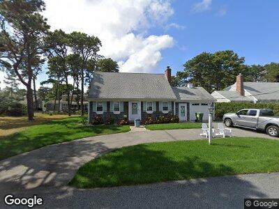
65 Bain Rd Dennis Port, MA 02639
Dennis Port NeighborhoodEstimated Value: $667,000 - $793,000
2
Beds
2
Baths
1,564
Sq Ft
$471/Sq Ft
Est. Value
About This Home
This home is located at 65 Bain Rd, Dennis Port, MA 02639 and is currently estimated at $736,014, approximately $470 per square foot. 65 Bain Rd is a home located in Barnstable County with nearby schools including Dennis-Yarmouth Regional High School and St. Pius X. School.
Ownership History
Date
Name
Owned For
Owner Type
Purchase Details
Closed on
Aug 5, 2021
Sold by
Frisina Louis R and Frisina Lillian F
Bought by
Foley Tracey A and Foley Brian M
Current Estimated Value
Home Financials for this Owner
Home Financials are based on the most recent Mortgage that was taken out on this home.
Original Mortgage
$448,000
Outstanding Balance
$413,146
Interest Rate
3%
Mortgage Type
Purchase Money Mortgage
Estimated Equity
$320,520
Purchase Details
Closed on
Dec 5, 2008
Sold by
Raf Rt
Bought by
Frisina Lillian F and Frisina Louis R
Create a Home Valuation Report for This Property
The Home Valuation Report is an in-depth analysis detailing your home's value as well as a comparison with similar homes in the area
Home Values in the Area
Average Home Value in this Area
Purchase History
| Date | Buyer | Sale Price | Title Company |
|---|---|---|---|
| Foley Tracey A | $560,000 | None Available | |
| Frisina Lillian F | -- | -- |
Source: Public Records
Mortgage History
| Date | Status | Borrower | Loan Amount |
|---|---|---|---|
| Open | Foley Tracey A | $163,400 | |
| Open | Foley Tracey A | $448,000 | |
| Previous Owner | Frisina Lillian I | $175,000 |
Source: Public Records
Tax History Compared to Growth
Tax History
| Year | Tax Paid | Tax Assessment Tax Assessment Total Assessment is a certain percentage of the fair market value that is determined by local assessors to be the total taxable value of land and additions on the property. | Land | Improvement |
|---|---|---|---|---|
| 2025 | $3,079 | $711,100 | $281,400 | $429,700 |
| 2024 | $2,995 | $682,200 | $270,700 | $411,500 |
| 2023 | $2,897 | $620,300 | $246,000 | $374,300 |
| 2022 | $2,644 | $472,100 | $193,900 | $278,200 |
| 2021 | $2,457 | $407,500 | $190,100 | $217,400 |
| 2020 | $2,410 | $395,000 | $190,100 | $204,900 |
| 2019 | $2,375 | $384,900 | $202,400 | $182,500 |
| 2018 | $2,314 | $365,000 | $192,700 | $172,300 |
| 2017 | $2,151 | $349,800 | $177,500 | $172,300 |
| 2016 | $2,044 | $313,000 | $167,300 | $145,700 |
| 2015 | $2,003 | $313,000 | $167,300 | $145,700 |
| 2014 | $1,894 | $298,300 | $157,200 | $141,100 |
Source: Public Records
Map
Nearby Homes
- 69 Beaten Rd Unit 13
- 75 Beaten Rd Unit 12
- 112 Old Wharf Rd Unit E4
- 188 Captain Chase Rd
- 174 Captain Chase Rd Unit 10
- 19 Ocean Dr Unit 2
- 113 Old Wharf Rd Unit 13
- 154 Old Wharf Rd Unit 36
- 154 Old Wharf Rd Unit 14
- 109 Lower County Rd
- 226 Old Wharf Rd
- 218 Old Wharf Rd Unit 218
- 218 Old Wharf Rd Unit 309
- 218 Old Wharf (218 Sand Spit) Rd
- 31 Northern Ave
- 242 Old Wharf Rd Unit F7
- 91 Cynthia Ln
- 241 Old Wharf Rd Unit 90
- 241 Old Wharf Rd Unit 88
- 241 Old Wharf Rd Unit 85