Estimated Value: $261,664 - $340,000
3
Beds
2
Baths
1,502
Sq Ft
$201/Sq Ft
Est. Value
About This Home
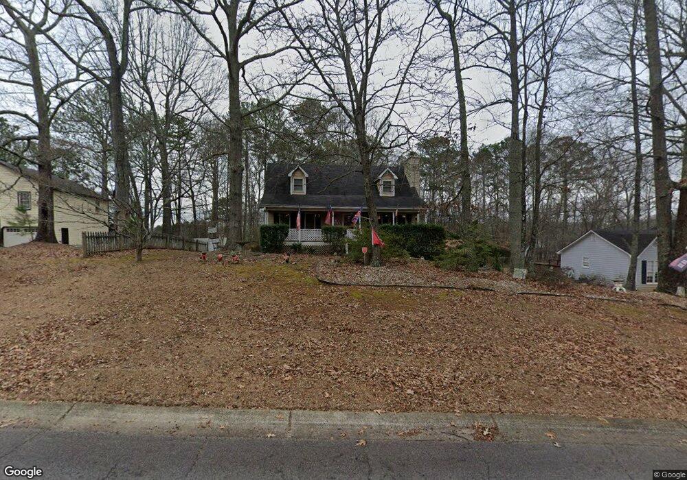
This home is located at 65 Jamie Dr, Hiram, GA 30141 and is currently estimated at $302,416, approximately $201 per square foot. 65 Jamie Dr is a home located in Paulding County with nearby schools including Connie Dugan Elementary School, Irma C. Austin Middle School, and South Paulding High School.
Ownership History
Date
Name
Owned For
Owner Type
Purchase Details
Closed on
Sep 8, 2017
Sold by
Lively Stan
Bought by
Lively Stan and Lively Deborah C
Current Estimated Value
Home Financials for this Owner
Home Financials are based on the most recent Mortgage that was taken out on this home.
Original Mortgage
$112,441
Outstanding Balance
$94,765
Interest Rate
4.25%
Mortgage Type
FHA
Estimated Equity
$207,651
Purchase Details
Closed on
Jun 1, 2004
Sold by
Lively Stanley L
Bought by
Lively Stan
Home Financials for this Owner
Home Financials are based on the most recent Mortgage that was taken out on this home.
Original Mortgage
$80,000
Interest Rate
6.25%
Mortgage Type
New Conventional
Purchase Details
Closed on
Feb 6, 1996
Sold by
Lee Thomas H Rosa T
Bought by
Norwest Mtg
Create a Home Valuation Report for This Property
The Home Valuation Report is an in-depth analysis detailing your home's value as well as a comparison with similar homes in the area
Home Values in the Area
Average Home Value in this Area
Purchase History
| Date | Buyer | Sale Price | Title Company |
|---|---|---|---|
| Lively Stan | -- | -- | |
| Lively Stan | $100,000 | -- | |
| Norwest Mtg | $81,300 | -- |
Source: Public Records
Mortgage History
| Date | Status | Borrower | Loan Amount |
|---|---|---|---|
| Open | Lively Stan | $112,441 | |
| Previous Owner | Lively Stan | $80,000 |
Source: Public Records
Tax History Compared to Growth
Tax History
| Year | Tax Paid | Tax Assessment Tax Assessment Total Assessment is a certain percentage of the fair market value that is determined by local assessors to be the total taxable value of land and additions on the property. | Land | Improvement |
|---|---|---|---|---|
| 2024 | $719 | $108,360 | $12,000 | $96,360 |
| 2023 | $809 | $103,312 | $12,000 | $91,312 |
| 2022 | $728 | $91,532 | $12,000 | $79,532 |
| 2021 | $641 | $66,164 | $10,000 | $56,164 |
| 2020 | $654 | $63,696 | $10,000 | $53,696 |
| 2019 | $592 | $56,020 | $10,000 | $46,020 |
| 2018 | $972 | $53,728 | $10,000 | $43,728 |
| 2017 | $925 | $50,524 | $10,000 | $40,524 |
| 2016 | $813 | $45,800 | $10,000 | $35,800 |
| 2015 | $770 | $42,824 | $10,000 | $32,824 |
| 2014 | $558 | $31,916 | $10,000 | $21,916 |
| 2013 | -- | $30,240 | $12,000 | $18,240 |
Source: Public Records
Map
Nearby Homes
- 269 Shelby Ln
- 263 Chandler Ridge Dr
- 239 Clear Brook Trail
- 23 Bomar Ln
- 42 Crystal Springs Dr
- 289 Ridge Run Dr
- 3061 Dallas Nebo Rd
- 554 Oak Landing Cir
- 280 Glenn Eagles Way
- 43 Oak Landing Cir
- 88 Lambeth Dr
- 210 Creekside Overlook
- 59 Creekside Bluff
- 976 Bakers Bridge Rd
- 55 Hayes Trace
- 1267 Austin Bridge Rd
- 56 Creekside Point
- 1150 Denton Rd Unit 371