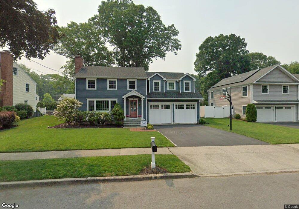
65 Shadowood Rd Fairfield, CT 06824
University NeighborhoodEstimated Value: $919,000 - $1,375,000
5
Beds
3
Baths
2,503
Sq Ft
$469/Sq Ft
Est. Value
About This Home
This home is located at 65 Shadowood Rd, Fairfield, CT 06824 and is currently estimated at $1,173,137, approximately $468 per square foot. 65 Shadowood Rd is a home located in Fairfield County with nearby schools including Riverfield Elementary School, Roger Ludlowe Middle School, and Fairfield Ludlowe High School.
Ownership History
Date
Name
Owned For
Owner Type
Purchase Details
Closed on
Jun 14, 2007
Sold by
Est Dooley Elizabeth A and Waltersdorf Carol
Bought by
Martino Matthew J and Martino Shannon
Current Estimated Value
Home Financials for this Owner
Home Financials are based on the most recent Mortgage that was taken out on this home.
Original Mortgage
$417,000
Interest Rate
6.19%
Create a Home Valuation Report for This Property
The Home Valuation Report is an in-depth analysis detailing your home's value as well as a comparison with similar homes in the area
Home Values in the Area
Average Home Value in this Area
Purchase History
| Date | Buyer | Sale Price | Title Company |
|---|---|---|---|
| Martino Matthew J | $625,000 | -- | |
| Martino Matthew J | $625,000 | -- |
Source: Public Records
Mortgage History
| Date | Status | Borrower | Loan Amount |
|---|---|---|---|
| Open | Martino Matthew J | $121,500 | |
| Open | Martino Matthew J | $412,000 | |
| Closed | Martino Matthew J | $413,500 | |
| Closed | Martino Matthew J | $417,000 |
Source: Public Records
Tax History
| Year | Tax Paid | Tax Assessment Tax Assessment Total Assessment is a certain percentage of the fair market value that is determined by local assessors to be the total taxable value of land and additions on the property. | Land | Improvement |
|---|---|---|---|---|
| 2025 | $13,313 | $468,930 | $258,930 | $210,000 |
| 2024 | $13,083 | $468,930 | $258,930 | $210,000 |
| 2023 | $12,900 | $468,930 | $258,930 | $210,000 |
| 2022 | $12,774 | $468,930 | $258,930 | $210,000 |
| 2021 | $12,652 | $468,930 | $258,930 | $210,000 |
| 2020 | $13,174 | $491,750 | $256,200 | $235,550 |
| 2019 | $13,174 | $491,750 | $256,200 | $235,550 |
| 2018 | $12,963 | $491,750 | $256,200 | $235,550 |
| 2017 | $12,697 | $491,750 | $256,200 | $235,550 |
| 2016 | $10,489 | $412,160 | $256,200 | $155,960 |
| 2015 | $10,110 | $407,820 | $271,950 | $135,870 |
| 2014 | $9,951 | $407,820 | $271,950 | $135,870 |
Source: Public Records
Map
Nearby Homes
- 1353 Mill Plain Rd
- 1091 Round Hill Rd
- 360 Duck Farm Rd
- 148 Millspaugh Dr
- 218 Lower Farm Rd
- 1478 Jennings Rd
- 20 Ermine St
- 42 Robin Cir
- 341 Crestwood Rd
- 15 Barton Rd
- 196 Robin Ln
- 68 Figlar Ave
- 164 Wakeman Rd
- 359 Reid St
- 647 Bronson Rd
- 245 Reid St
- 70 Meadow Ridge Rd
- 77 Meadowbrook Rd
- 54 Ridgedale Rd
- 11 Tuckahoe Ln
- 53 Shadowood Rd
- 83 Shadowood Rd
- 110 Limerick Rd
- 70 Shadowood Rd
- 58 Shadowood Rd
- 122 Limerick Rd
- 35 Shadowood Rd
- 86 Shadowood Rd
- 70 Limerick Rd
- 94 Limerick Rd
- 40 Shadowood Rd
- 103 Limerick Rd
- 30 Shadowood Rd
- 42 Limerick Rd
- 20 Shadowood Rd
- 120 Charter Oak Rd
- 119 Limerick Rd
- 115 Charter Oak Rd
- 37 Limerick Rd
- 1550 Mill Plain Rd
Your Personal Tour Guide
Ask me questions while you tour the home.