
Seller's Agent in 2025
Paul Grover
Berkshire Hathaway HomeServices Robert Paul Properties
(508) 420-1448
40 in this area
216 Total Sales
Estimated Value: $1,261,387 - $1,334,000
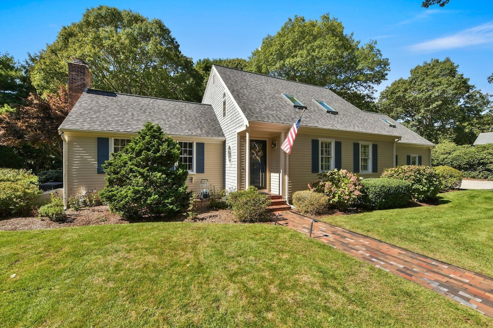
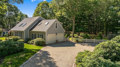
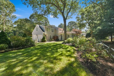
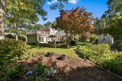
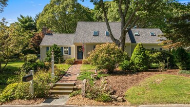
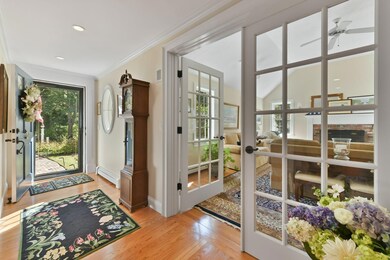
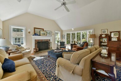
Tucked away in the serene Cotuit Coves neighborhood of Cotuit, this timeless Cape Cod home offers the perfect blend of charm, comfort, and convenience. Set on nearly half an acre of beautifully landscaped grounds, the property provides privacy and tranquility with mature trees and lush plantings that invite you to slow down and enjoy each day. The home is thoughtfully designed for relaxed living and entertaining. A bluestone patio surrounded by stone walls creates an inviting space for morning coffee or evening cocktails, while the spacious second-floor deck ensures effortless indoor-outdoor enjoyment. Inside, sun-filled rooms with vaulted ceilings, exposed beams, and skylights create an airy, welcoming atmosphere. The heart of the home is a chef's kitchen with top-tier Wolf appliances and a breakfast bar - perfect for casual meals or entertaining friends. The adjoining fireplaced living room and dining area provide a warm setting for family gatherings or quiet evenings at home. The convenience of a first-floor primary suite means you can enjoy single-level living every day, while guests and family will appreciate the two additional bedrooms, full bathrooms, den, and bonus room upstairs. Additional comforts include an attached two-car garage, outdoor shower, and garden shed - all designed for easy, low-maintenance living. Just steps from the Crocker Neck Conservation Area and minutes from Cotuit Village, Willowbend, and Mashpee Commons, this home places you close to scenic walking trails, golf, dining, and shopping. Whether you're looking for a peaceful year-round residence or a seasonal retreat, this property offers the ideal setting to enjoy the Cape lifestyle at its very best. The information contained herein has been obtained through sources deemed reliable but cannot be guaranteed as to its accuracy. Buyers are encouraged to do their own due diligence through independent verification.
Last Agent to Sell the Property
Berkshire Hathaway HomeServices Robert Paul Properties License #125463 Listed on: 10/03/2025
| Date | Buyer | Sale Price | Title Company |
|---|---|---|---|
| Matthews William | $1,300,000 | -- | |
| Ganey Gerard F | $517,500 | -- | |
| Saylor Carlyle L | $227,000 | -- |
| Date | Status | Borrower | Loan Amount |
|---|---|---|---|
| Previous Owner | Saylor Carlyle L | $175,000 |
| Date | Event | Price | List to Sale | Price per Sq Ft |
|---|---|---|---|---|
| 11/25/2025 11/25/25 | Sold | $1,300,000 | -3.7% | $425 / Sq Ft |
| 11/12/2025 11/12/25 | Pending | -- | -- | -- |
| 10/03/2025 10/03/25 | For Sale | $1,350,000 | -- | $442 / Sq Ft |
| Year | Tax Paid | Tax Assessment Tax Assessment Total Assessment is a certain percentage of the fair market value that is determined by local assessors to be the total taxable value of land and additions on the property. | Land | Improvement |
|---|---|---|---|---|
| 2025 | $8,531 | $1,021,700 | $342,900 | $678,800 |
| 2024 | $7,759 | $984,600 | $342,900 | $641,700 |
| 2023 | $7,478 | $893,400 | $318,800 | $574,600 |
| 2022 | $7,252 | $701,400 | $220,400 | $481,000 |
| 2021 | $6,947 | $629,200 | $241,400 | $387,800 |
| 2020 | $7,055 | $602,500 | $241,400 | $361,100 |
| 2019 | $6,844 | $576,100 | $251,900 | $324,200 |
| 2018 | $6,330 | $532,800 | $254,100 | $278,700 |
| 2017 | $6,124 | $519,000 | $254,100 | $264,900 |
| 2016 | $6,515 | $566,000 | $301,100 | $264,900 |
| 2015 | $6,409 | $556,300 | $294,300 | $262,000 |
Seller's Agent in 2025
Paul Grover
Berkshire Hathaway HomeServices Robert Paul Properties
(508) 420-1448
40 in this area
216 Total Sales
Buyer's Agent in 2025
Cindy Lee Caldwell
Sotheby's International Realty
(508) 737-5670
3 in this area
48 Total Sales
Source: Cape Cod & Islands Association of REALTORS®
MLS Number: 22504963
APN: COTU-000005-000000-000061
Disclaimer: Certain information contained herein is derived from information provided by parties other than Homes.com. All information provided is deemed reliable, but is not guaranteed to be accurate and should be independently verified.
![]() All data relating to real estate for sale on this page comes from the Broker Reciprocity (BR) of the Cape Cod & Islands Multiple Listing Service, Inc. Detailed information about real estate listings held by brokerage firms other than CC&I Assoc. of REALTORS®, Inc. includes the name of the listing company. Neither the listing company nor CC&I Assoc. of REALTORS®, Inc. shall be responsible for any typographical errors, misinformation, misprints and shall be held totally harmless. The Broker providing this data believes it to be correct, but advises interested parties to confirm any item before relying on it in a purchase decision. All properties are subject to prior sale, changes, or withdrawal. Copyright 2026 © Cape Cod & Islands Multiple Listing Service, Inc. All rights reserved.
All data relating to real estate for sale on this page comes from the Broker Reciprocity (BR) of the Cape Cod & Islands Multiple Listing Service, Inc. Detailed information about real estate listings held by brokerage firms other than CC&I Assoc. of REALTORS®, Inc. includes the name of the listing company. Neither the listing company nor CC&I Assoc. of REALTORS®, Inc. shall be responsible for any typographical errors, misinformation, misprints and shall be held totally harmless. The Broker providing this data believes it to be correct, but advises interested parties to confirm any item before relying on it in a purchase decision. All properties are subject to prior sale, changes, or withdrawal. Copyright 2026 © Cape Cod & Islands Multiple Listing Service, Inc. All rights reserved.
Ask me questions while you tour the home.