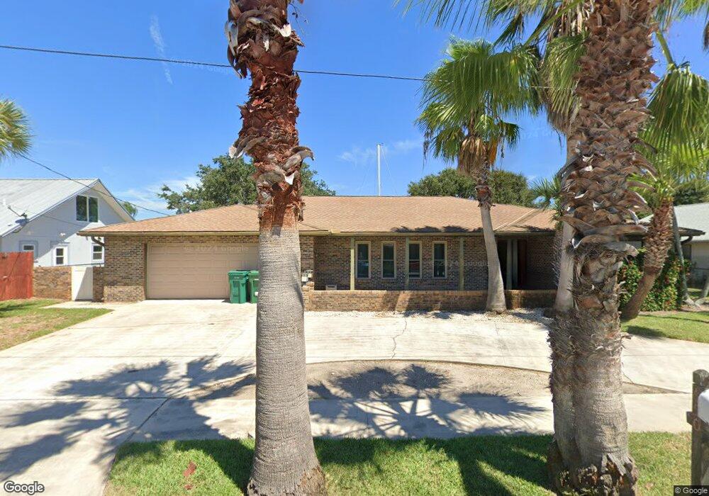
650 Canal Ct Satellite Beach, FL 32937
Estimated Value: $511,000 - $881,000
3
Beds
2
Baths
2,667
Sq Ft
$262/Sq Ft
Est. Value
About This Home
This home is located at 650 Canal Ct, Satellite Beach, FL 32937 and is currently estimated at $697,595, approximately $261 per square foot. 650 Canal Ct is a home located in Brevard County with nearby schools including Spessard L. Holland Elementary School, Satellite Senior High School, and DeLaura Middle School.
Ownership History
Date
Name
Owned For
Owner Type
Purchase Details
Closed on
Oct 14, 2025
Sold by
Markle Brian and Markle Sara
Bought by
Terry Steven L and Terry Jeanne
Current Estimated Value
Home Financials for this Owner
Home Financials are based on the most recent Mortgage that was taken out on this home.
Original Mortgage
$300,000
Outstanding Balance
$300,000
Interest Rate
6%
Mortgage Type
Seller Take Back
Estimated Equity
$397,595
Purchase Details
Closed on
Dec 5, 2024
Sold by
Wiley Robert E
Bought by
Markle Brian and Markle Sara
Purchase Details
Closed on
Jul 10, 2024
Sold by
Wiley Robert E
Bought by
Wiley Robert E and Clement Lavinia
Purchase Details
Closed on
Sep 8, 1997
Sold by
Ciambrone Thomas W and Ciambrone Theresa E
Bought by
Farley Wiley Robert E and Farley Wiley Judith
Home Financials for this Owner
Home Financials are based on the most recent Mortgage that was taken out on this home.
Original Mortgage
$184,000
Interest Rate
7.39%
Create a Home Valuation Report for This Property
The Home Valuation Report is an in-depth analysis detailing your home's value as well as a comparison with similar homes in the area
Home Values in the Area
Average Home Value in this Area
Purchase History
| Date | Buyer | Sale Price | Title Company |
|---|---|---|---|
| Terry Steven L | $750,000 | Alliance Title | |
| Markle Brian | $520,000 | Alliance Title | |
| Markle Brian | $520,000 | Alliance Title | |
| Wiley Robert E | $100 | None Listed On Document | |
| Farley Wiley Robert E | $239,500 | -- |
Source: Public Records
Mortgage History
| Date | Status | Borrower | Loan Amount |
|---|---|---|---|
| Open | Terry Steven L | $300,000 | |
| Previous Owner | Farley Wiley Robert E | $184,000 |
Source: Public Records
Tax History Compared to Growth
Tax History
| Year | Tax Paid | Tax Assessment Tax Assessment Total Assessment is a certain percentage of the fair market value that is determined by local assessors to be the total taxable value of land and additions on the property. | Land | Improvement |
|---|---|---|---|---|
| 2025 | $5,925 | $814,870 | -- | -- |
| 2024 | $5,852 | $352,170 | -- | -- |
| 2023 | $5,852 | $341,920 | $0 | $0 |
| 2022 | $5,511 | $331,970 | $0 | $0 |
| 2021 | $5,718 | $322,310 | $0 | $0 |
| 2020 | $5,710 | $317,860 | $0 | $0 |
| 2019 | $5,688 | $310,720 | $0 | $0 |
| 2018 | $5,707 | $304,930 | $0 | $0 |
| 2017 | $5,454 | $298,660 | $0 | $0 |
| 2016 | $5,486 | $292,520 | $220,000 | $72,520 |
| 2015 | $5,626 | $290,490 | $200,000 | $90,490 |
| 2014 | $5,642 | $288,190 | $175,000 | $113,190 |
Source: Public Records
Map
Nearby Homes
- 695 Jackson Ct
- 100 Matthews St
- 612 Mar Brisa Ct
- 327 Lansing Island Dr
- 702 Mar Brisa Ct Unit U702
- Pearson End Unit Plan at Tortuga Cay
- Pearson Interior Unit Plan at Tortuga Cay
- 53 Emerald Ct
- 527 Wilson Ave
- 525 Wilson Ave
- 595 Park Ave Unit 1
- 11 Barbara Ct
- 520 Lee Ave
- 37 Tortuga Trail
- 35 Tortuga Trail
- 33 Tortuga Trail
- 31 Tortuga Trail
- 29 Tortuga Trail
- 27 Tortuga Trail
- 36 Sunset St