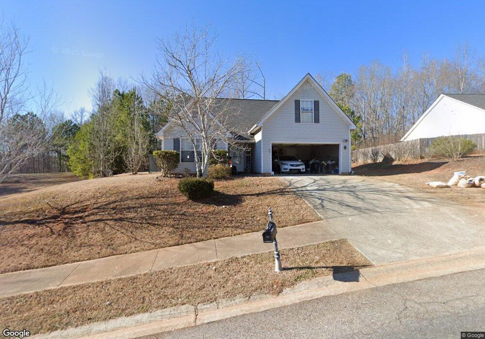
650 Maple Forge Dr Athens, GA 30606
Estimated Value: $307,000 - $325,000
3
Beds
2
Baths
1,679
Sq Ft
$188/Sq Ft
Est. Value
About This Home
This home is located at 650 Maple Forge Dr, Athens, GA 30606 and is currently estimated at $315,734, approximately $188 per square foot. 650 Maple Forge Dr is a home located in Clarke County with nearby schools including Whitehead Road Elementary School, Burney-Harris-Lyons Middle School, and Clarke Central High School.
Ownership History
Date
Name
Owned For
Owner Type
Purchase Details
Closed on
Nov 1, 2018
Sold by
Lonon Deborah
Bought by
Adlf Llc
Current Estimated Value
Purchase Details
Closed on
Jun 20, 2011
Sold by
Grant Kervon
Bought by
Lonon Deborah
Purchase Details
Closed on
May 12, 2004
Sold by
Smh Builders Llc
Bought by
Grant Kervon
Purchase Details
Closed on
Oct 22, 2002
Sold by
Millwater Management Corporati
Bought by
Smh Builders Llc
Create a Home Valuation Report for This Property
The Home Valuation Report is an in-depth analysis detailing your home's value as well as a comparison with similar homes in the area
Purchase History
| Date | Buyer | Sale Price | Title Company |
|---|---|---|---|
| Adlf Llc | -- | -- | |
| Lonon Deborah | $131,500 | -- | |
| Grant Kervon | $131,500 | -- | |
| Smh Builders Llc | $45,000 | -- | |
| Millwater Management Corporation Inc | $29,000 | -- |
Source: Public Records
Tax History
| Year | Tax Paid | Tax Assessment Tax Assessment Total Assessment is a certain percentage of the fair market value that is determined by local assessors to be the total taxable value of land and additions on the property. | Land | Improvement |
|---|---|---|---|---|
| 2025 | $3,547 | $114,246 | $12,000 | $102,246 |
| 2024 | $3,547 | $104,263 | $12,000 | $92,263 |
| 2023 | $3,258 | $98,683 | $12,000 | $86,683 |
| 2022 | $2,619 | $82,103 | $10,400 | $71,703 |
| 2021 | $2,173 | $64,468 | $10,400 | $54,068 |
| 2020 | $2,022 | $60,011 | $10,400 | $49,611 |
| 2019 | $1,885 | $55,511 | $10,400 | $45,111 |
| 2018 | $1,763 | $51,922 | $10,400 | $41,522 |
| 2017 | $1,572 | $46,300 | $10,400 | $35,900 |
| 2016 | $1,550 | $45,644 | $10,400 | $35,244 |
| 2015 | $1,510 | $44,424 | $10,400 | $34,024 |
| 2014 | $1,358 | $39,892 | $10,400 | $29,492 |
Source: Public Records
Map
Nearby Homes
- 207 Wisteria Way
- 390 Lakeland Dr
- 650 Lakeland Way
- 283 Lake Vista Way
- 105 Red Bluff Dr
- 309 Jasmine Trail
- 185 Boundary St
- 413 Jasmine Trail
- 245 Federal St
- 15 Chestnut Oak Run
- 83 Charter Oak Dr
- 265 Federal St
- 6 Oak Grove Rd
- 1175 Lavender Rd
- 25 Charter Oak Dr
- 230 Rustwood Dr
- 300 Lavender Rd
- 395 Round Table Rd
- 265 Round Table Rd
- 180 Ramble Hills Cir Unit 180 & 182
- 640 Maple Forge Dr
- 660 Maple Forge Dr
- 630 Maple Forge Dr
- 670 Maple Forge Dr
- 655 Maple Forge Dr
- 665 Maple Forge Dr
- 645 Maple Forge Dr
- 620 Maple Forge Dr
- 635 Maple Forge Dr
- 610 Maple Forge Dr
- 625 Maple Forge Dr
- 600 Maple Forge Dr
- 615 Maple Forge Dr
- 605 Maple Forge Dr
- 570 Maple Forge Dr
- 135 Maple Forge Dr
- 145 Maple Forge Dr
- 155 Maple Forge Dr
- 125 Maple Forge Dr
- 115 Maple Forge Dr
Your Personal Tour Guide
Ask me questions while you tour the home.