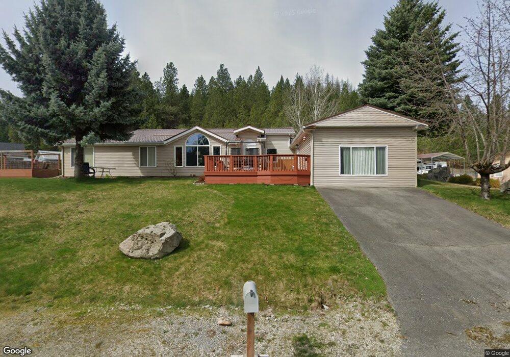
650 Skyline Dr Pinehurst, ID 83850
Estimated Value: $362,230 - $492,000
Studio
--
Bath
130
Sq Ft
$3,200/Sq Ft
Est. Value
About This Home
This home is located at 650 Skyline Dr, Pinehurst, ID 83850 and is currently estimated at $416,058, approximately $3,200 per square foot. 650 Skyline Dr is a home with nearby schools including Pinehurst Elementary School, Kellogg Middle School, and Kellogg High School.
Ownership History
Date
Name
Owned For
Owner Type
Purchase Details
Closed on
Jul 8, 2025
Sold by
Brady Sharla G
Bought by
Durham Franklin Chad Daniel and Durham Jackie Rae
Current Estimated Value
Purchase Details
Closed on
Oct 19, 2022
Sold by
Durham Frank C and Durham Jackie R
Bought by
Helms W Jay W and Helms Janice M
Purchase Details
Closed on
Oct 29, 2020
Sold by
Frazier Timothy Jay and Frazier Kayla
Bought by
Landes Meg Yvonne
Purchase Details
Closed on
Jun 21, 2011
Sold by
Sainsbury James E and Sainsbury Pauline
Bought by
Durham Franklin C and Durham Jackie R
Home Financials for this Owner
Home Financials are based on the most recent Mortgage that was taken out on this home.
Original Mortgage
$180,750
Interest Rate
4.56%
Create a Home Valuation Report for This Property
The Home Valuation Report is an in-depth analysis detailing your home's value as well as a comparison with similar homes in the area
Purchase History
| Date | Buyer | Sale Price | Title Company |
|---|---|---|---|
| Durham Franklin Chad Daniel | -- | Alliance Title | |
| Helms W Jay W | -- | First American Title | |
| Landes Meg Yvonne | -- | First American Ttl Co Kello | |
| Durham Franklin C | -- | -- |
Source: Public Records
Mortgage History
| Date | Status | Borrower | Loan Amount |
|---|---|---|---|
| Previous Owner | Durham Franklin C | $180,750 |
Source: Public Records
Tax History
| Year | Tax Paid | Tax Assessment Tax Assessment Total Assessment is a certain percentage of the fair market value that is determined by local assessors to be the total taxable value of land and additions on the property. | Land | Improvement |
|---|---|---|---|---|
| 2025 | $1,272 | $389,862 | $104,652 | $285,210 |
| 2024 | $1,739 | $389,862 | $104,652 | $285,210 |
| 2023 | $1,739 | $381,371 | $104,652 | $276,719 |
| 2022 | $1,799 | $323,236 | $90,805 | $232,431 |
| 2021 | $1,557 | $235,506 | $64,723 | $170,783 |
| 2020 | $1,528 | $218,684 | $57,000 | $161,684 |
| 2019 | $1,254 | $178,127 | $52,000 | $126,127 |
| 2018 | $1,286 | $159,978 | $52,000 | $107,978 |
| 2017 | $1,251 | $159,978 | $52,000 | $107,978 |
| 2016 | $1,323 | $162,441 | $52,000 | $110,441 |
| 2015 | -- | $160,131 | $51,000 | $109,131 |
| 2014 | -- | $156,261 | $51,000 | $105,261 |
Source: Public Records
Map
Nearby Homes
- 4.88 Acres Wallace Ave
- 502 Lewiston Ave
- 605 Lewiston Ave
- 0 Lot J Frosty Ln Unit 25-9282
- 208 S 6th St
- 202 Silver Saddle Ct
- 207 S Division St
- 305 S 1st
- 301 Woodland Dr
- Lot A Blue Star Ln
- NKA Parcel B
- NNA Frosty Lane Lot I
- 483 Paradise Ln
- 317 Power Ave
- 2972 Southfork Ridge Rd
- 101 Happy Trails Ln
- NKA Parcel A
- 6 Maple Ave
- 203 Palomino
- 207 Palamino Ct
Your Personal Tour Guide
Ask me questions while you tour the home.