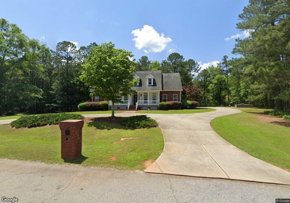
650 St Andrews Dr Jackson, GA 30233
Estimated Value: $515,000 - $726,000
5
Beds
4
Baths
3,268
Sq Ft
$175/Sq Ft
Est. Value
About This Home
This home is located at 650 St Andrews Dr, Jackson, GA 30233 and is currently estimated at $573,293, approximately $175 per square foot. 650 St Andrews Dr is a home located in Butts County with nearby schools including Jackson High School.
Ownership History
Date
Name
Owned For
Owner Type
Purchase Details
Closed on
Apr 28, 2008
Sold by
Collins Jeffery D
Bought by
Collins Sohmer E
Current Estimated Value
Purchase Details
Closed on
Jul 13, 2006
Sold by
Not Provided
Bought by
Collins Sohmer E
Purchase Details
Closed on
Sep 14, 2005
Sold by
Garland Fam Properties
Bought by
Used Furniture Barn Inc
Purchase Details
Closed on
Jan 25, 2005
Sold by
Garland Benjamin M
Bought by
Garland Fam Properties
Create a Home Valuation Report for This Property
The Home Valuation Report is an in-depth analysis detailing your home's value as well as a comparison with similar homes in the area
Home Values in the Area
Average Home Value in this Area
Purchase History
| Date | Buyer | Sale Price | Title Company |
|---|---|---|---|
| Collins Sohmer E | -- | -- | |
| Collins Sohmer E | $316,700 | -- | |
| Used Furniture Barn Inc | $33,668 | -- | |
| Garland Fam Properties | -- | -- |
Source: Public Records
Tax History Compared to Growth
Tax History
| Year | Tax Paid | Tax Assessment Tax Assessment Total Assessment is a certain percentage of the fair market value that is determined by local assessors to be the total taxable value of land and additions on the property. | Land | Improvement |
|---|---|---|---|---|
| 2024 | $5,422 | $233,040 | $15,960 | $217,080 |
| 2023 | $5,624 | $223,152 | $15,960 | $207,192 |
| 2022 | $4,998 | $184,180 | $12,000 | $172,180 |
| 2021 | $4,737 | $163,094 | $12,000 | $151,094 |
| 2020 | $4,753 | $157,540 | $12,000 | $145,540 |
| 2019 | $3,589 | $123,035 | $12,000 | $111,035 |
| 2018 | $3,458 | $113,626 | $12,000 | $101,626 |
| 2017 | $2,988 | $96,464 | $12,000 | $84,464 |
| 2016 | $3,014 | $94,864 | $10,400 | $84,464 |
| 2015 | $2,714 | $94,864 | $10,400 | $84,464 |
| 2014 | $2,872 | $81,670 | $10,400 | $71,270 |
Source: Public Records
Map
Nearby Homes
- 375 Saint Andrews Dr
- 0 Morningside Ct Unit 10557547
- 330 James Moore Cir
- 323 Maddox Cir
- 143 Valley Hills Rd
- 0 Macon Ave Unit 179549
- 0 Macon Ave Unit 10514173
- 1375 Highway 42 S
- 908 Nelson St
- 14 Weaver St
- 144 Blake Ave
- 1065 Nelson St
- 965 Nelson St
- 119 Taylor Rd
- 591 Freeman St
- 544 Franklin St
- 1263 Highway 16 E
- 131 Taylor Rd
- 742 Joy St
- 347 Ww Carr Ave
- 650 Saint Andrews Dr
- 602 Saint Andrews Dr
- 0 St Andrews Unit 8995852
- 0 St Andrews Unit 8842967
- 0 St Andrews Unit 3132302
- 0 St Andrews Unit 3164840
- 0 St Andrews Unit 3185229
- 0 St Andrews Unit 7043717
- 0 St Andrews Unit 7301190
- 0 St Andrews Unit 7335864
- 0 St Andrews Unit 7346122
- 0 St Andrews Unit 7382726
- 0 St Andrews Unit 7458817
- 0 St Andrews Unit 8276969
- 0 St Andrews Unit 8545863
- 0 St Andrews Unit 8630783
- 0 St Andrews Unit 8675757
- 0 St Andrews Unit Lot 23 8668229
- 661 Saint Andrews Dr
- 574 Saint Andrews Dr