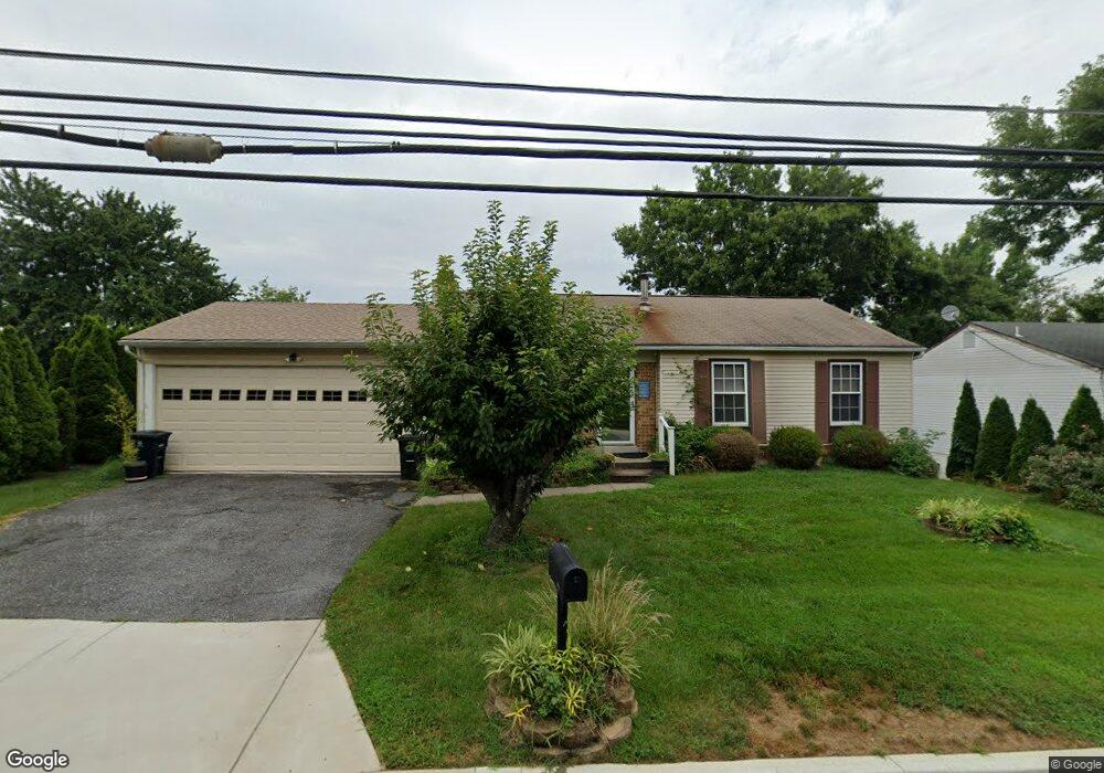
6502 Sandy Spring Rd Laurel, MD 20707
West Laurel NeighborhoodEstimated Value: $419,524 - $533,000
Studio
3
Baths
1,142
Sq Ft
$427/Sq Ft
Est. Value
About This Home
This home is located at 6502 Sandy Spring Rd, Laurel, MD 20707 and is currently estimated at $487,631, approximately $426 per square foot. 6502 Sandy Spring Rd is a home located in Prince George's County with nearby schools including Bond Mill Elementary, Martin Luther King Jr. Middle School, and Laurel High School.
Ownership History
Date
Name
Owned For
Owner Type
Purchase Details
Closed on
Nov 8, 2022
Sold by
Whitlow Tara F
Bought by
Whitlow Scott
Current Estimated Value
Purchase Details
Closed on
Oct 26, 2015
Sold by
Whitlow Ervin W
Bought by
Whitlow Byron S and Whitlow Tara F
Create a Home Valuation Report for This Property
The Home Valuation Report is an in-depth analysis detailing your home's value as well as a comparison with similar homes in the area
Home Values in the Area
Average Home Value in this Area
Purchase History
| Date | Buyer | Sale Price | Title Company |
|---|---|---|---|
| Whitlow Scott | -- | -- | |
| Whitlow Byron S | -- | None Available |
Source: Public Records
Tax History
| Year | Tax Paid | Tax Assessment Tax Assessment Total Assessment is a certain percentage of the fair market value that is determined by local assessors to be the total taxable value of land and additions on the property. | Land | Improvement |
|---|---|---|---|---|
| 2025 | $6,034 | $403,400 | $141,200 | $262,200 |
| 2024 | $6,034 | $379,200 | -- | -- |
| 2023 | $3,948 | $355,000 | $0 | $0 |
| 2022 | $3,679 | $330,800 | $101,200 | $229,600 |
| 2021 | $4,932 | $317,333 | $0 | $0 |
| 2020 | $4,837 | $303,867 | $0 | $0 |
| 2019 | $4,713 | $290,400 | $100,600 | $189,800 |
| 2018 | $4,695 | $289,167 | $0 | $0 |
| 2017 | $4,646 | $287,933 | $0 | $0 |
| 2016 | -- | $286,700 | $0 | $0 |
| 2015 | $4,427 | $282,067 | $0 | $0 |
| 2014 | $4,427 | $277,433 | $0 | $0 |
Source: Public Records
Map
Nearby Homes
- 6918 Scotch Dr
- 7002 Scotch Dr
- 1012 Flester Ln
- 6003 Windham Rd
- 1016 Flester Ln
- 1027 Overlook Way
- 1023 Flester Ln
- 7004 Fitzpatrick Dr
- 1106 Overlook Way
- 1024 Flester Ln
- 1023 Highpoint Trail
- 14005 Barkham Ct
- 7019 Fitzpatrick Dr
- 14717 Exbury Ln
- 7019 Redmiles Rd
- 15712 Dorset Rd Unit 104
- 15020 Cherrywood Dr
- 15046 Cherrywood Dr
- 15708 Dorset Rd Unit 202
- 6947 Mayfair Terrace
- 6502 Old Sandy Spring Rd
- 6504 Sandy Spring Rd
- 6500 Sandy Spring Rd
- 15403 Calshot Ct
- 15405 Calshot Ct
- 15401 Calshot Ct
- 6410 Sandy Spring Rd
- 6506 Sandy Spring Rd
- 15407 Calshot Ct
- 6408 Sandy Spring Rd
- 15400 Calshot Ct
- 6508 Sandy Spring Rd
- 15408 Calshot Ct
- 15409 Calshot Ct
- 15404 Calshot Ct
- 15303 Bounds Ave
- 15402 Calshot Ct
- 6406 Sandy Spring Rd
- 15305 Bounds Ave
- 15411 Calshot Ct
Your Personal Tour Guide
Ask me questions while you tour the home.