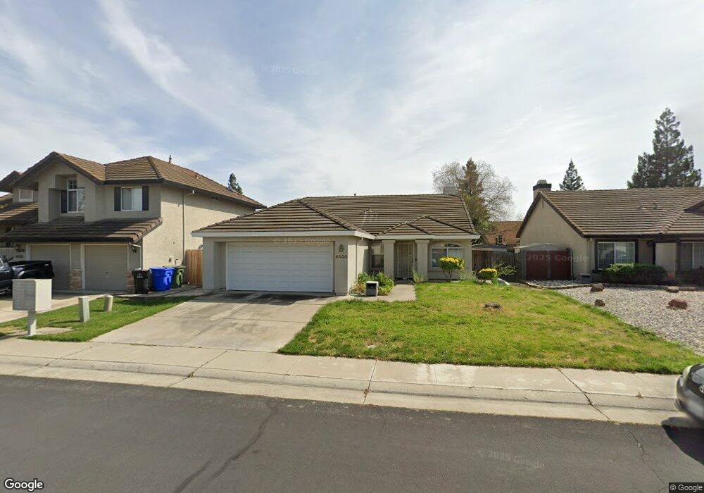
6508 Brockenhurst Dr Elk Grove, CA 95758
North West Elk Grove NeighborhoodEstimated Value: $375,000 - $554,000
4
Beds
2
Baths
1,568
Sq Ft
$321/Sq Ft
Est. Value
About This Home
This home is located at 6508 Brockenhurst Dr, Elk Grove, CA 95758 and is currently estimated at $503,616, approximately $321 per square foot. 6508 Brockenhurst Dr is a home located in Sacramento County with nearby schools including John Ehrhardt Elementary School, Harriet G. Eddy Middle School, and Laguna Creek High School.
Ownership History
Date
Name
Owned For
Owner Type
Purchase Details
Closed on
Sep 16, 2002
Sold by
Huang Shuo Kun and Huang Dong Mei
Bought by
Huang Shuo Kun and Huang Dong Mei
Current Estimated Value
Purchase Details
Closed on
Feb 24, 1997
Sold by
Parkland Homes Inc
Bought by
Huang Shuo Kun and Huang Dong Mei
Home Financials for this Owner
Home Financials are based on the most recent Mortgage that was taken out on this home.
Original Mortgage
$70,000
Interest Rate
7.86%
Create a Home Valuation Report for This Property
The Home Valuation Report is an in-depth analysis detailing your home's value as well as a comparison with similar homes in the area
Home Values in the Area
Average Home Value in this Area
Purchase History
| Date | Buyer | Sale Price | Title Company |
|---|---|---|---|
| Huang Shuo Kun | -- | -- | |
| Huang Shuo Kun | $127,500 | -- |
Source: Public Records
Mortgage History
| Date | Status | Borrower | Loan Amount |
|---|---|---|---|
| Closed | Huang Shuo Kun | $70,000 |
Source: Public Records
Tax History Compared to Growth
Tax History
| Year | Tax Paid | Tax Assessment Tax Assessment Total Assessment is a certain percentage of the fair market value that is determined by local assessors to be the total taxable value of land and additions on the property. | Land | Improvement |
|---|---|---|---|---|
| 2025 | $3,305 | $270,316 | $76,008 | $194,308 |
| 2024 | $3,305 | $265,017 | $74,518 | $190,499 |
| 2023 | $3,213 | $259,821 | $73,057 | $186,764 |
| 2022 | $3,161 | $254,727 | $71,625 | $183,102 |
| 2021 | $3,098 | $249,733 | $70,221 | $179,512 |
| 2020 | $3,052 | $247,173 | $69,501 | $177,672 |
| 2019 | $2,994 | $242,328 | $68,139 | $174,189 |
| 2018 | $2,915 | $237,577 | $66,803 | $170,774 |
| 2017 | $2,858 | $232,920 | $65,494 | $167,426 |
| 2016 | $2,730 | $228,354 | $64,210 | $164,144 |
| 2015 | $2,676 | $224,925 | $63,246 | $161,679 |
| 2014 | $2,641 | $220,520 | $62,008 | $158,512 |
Source: Public Records
Map
Nearby Homes
- 8869 Jessup Ct
- 6131 Jacinto Ave
- 6317 Jacinto Ave
- 6325 Jacinto Ave
- 6403 Jacinto Ave
- 6813 Springridge Way
- 6411 Jacinto Ave
- 6419 Jacinto Ave
- 6427 Jacinto Ave
- 6451 Jacinto Ave
- Danville Plan at Ventris Place
- Carefree Plan at Ventris Place
- Biltmore Plan at Ventris Place
- Astoria Plan at Ventris Place
- 6424 Ventris Walk
- 6509 Jacinto Ave
- 6441 Ventris Walk
- 6517 Jacinto Ave
- 6024 Deepdale Way
- 5809 Elk Spring Way
- 6512 Brockenhurst Dr
- 6504 Brockenhurst Dr
- 6509 Star Bird Ct
- 6516 Brockenhurst Dr
- 6500 Brockenhurst Dr
- 6513 Star Bird Ct
- 6505 Star Bird Ct
- 6509 Brockenhurst Dr
- 6517 Star Bird Ct
- 6513 Brockenhurst Dr
- 6505 Brockenhurst Dr
- 6501 Star Bird Ct
- 6501 Brockenhurst Dr
- 6517 Brockenhurst Dr
- 8832 Mannington St
- 8836 Mannington St
- 6416 Brockenhurst Dr
- 8840 Mannington St
- 8824 Mannington St
- 8828 Westside Way