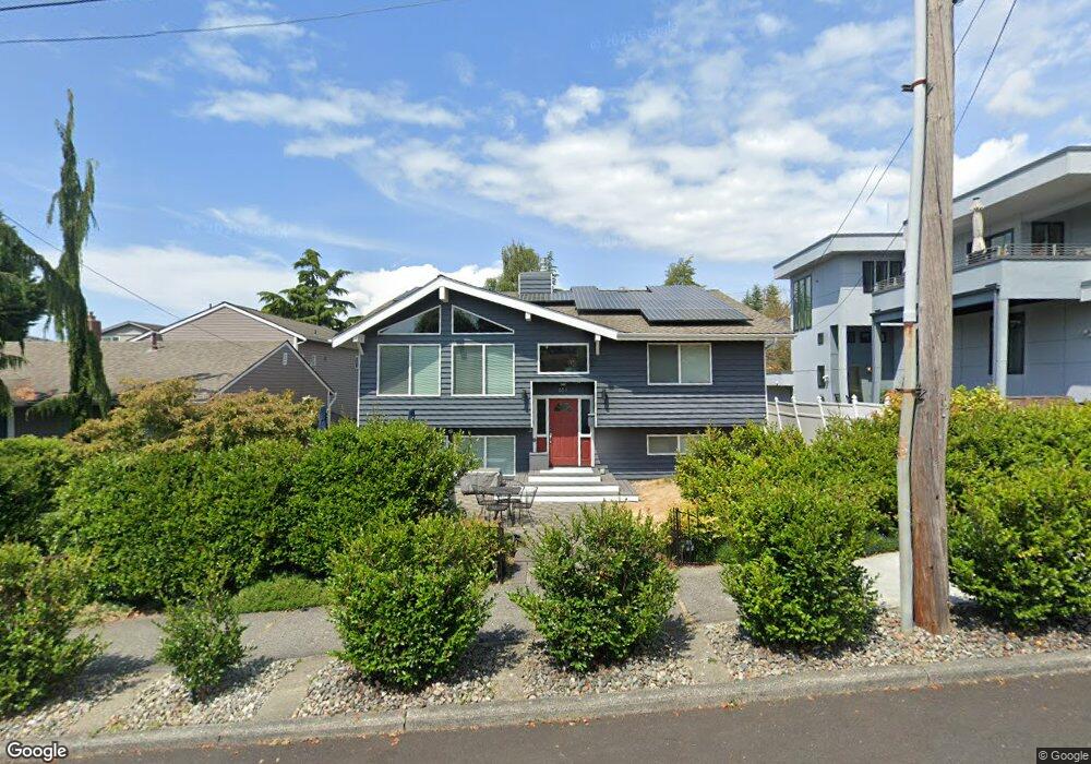
651 Maple St Edmonds, WA 98020
Downtown Edmonds NeighborhoodEstimated Value: $1,050,000 - $1,648,000
5
Beds
3
Baths
2,620
Sq Ft
$507/Sq Ft
Est. Value
About This Home
This home is located at 651 Maple St, Edmonds, WA 98020 and is currently estimated at $1,327,522, approximately $506 per square foot. 651 Maple St is a home located in Snohomish County with nearby schools including Sherwood Elementary School, College Place Middle School, and Edmonds-Woodway High School.
Ownership History
Date
Name
Owned For
Owner Type
Purchase Details
Closed on
Jun 22, 2000
Sold by
Marks Thomas and Marks Marsha J
Bought by
Borchert Richard Paul and Borchert Dianne C
Current Estimated Value
Home Financials for this Owner
Home Financials are based on the most recent Mortgage that was taken out on this home.
Original Mortgage
$248,400
Outstanding Balance
$89,503
Interest Rate
8.53%
Estimated Equity
$1,238,019
Purchase Details
Closed on
Apr 14, 1997
Sold by
Carter Joyce S
Bought by
Marks Thomas and Marks Marsha J
Home Financials for this Owner
Home Financials are based on the most recent Mortgage that was taken out on this home.
Original Mortgage
$214,225
Interest Rate
7.75%
Create a Home Valuation Report for This Property
The Home Valuation Report is an in-depth analysis detailing your home's value as well as a comparison with similar homes in the area
Home Values in the Area
Average Home Value in this Area
Purchase History
| Date | Buyer | Sale Price | Title Company |
|---|---|---|---|
| Borchert Richard Paul | $276,000 | -- | |
| Marks Thomas | $225,500 | First American Title Ins Co |
Source: Public Records
Mortgage History
| Date | Status | Borrower | Loan Amount |
|---|---|---|---|
| Open | Borchert Richard Paul | $248,400 | |
| Previous Owner | Marks Thomas | $214,225 |
Source: Public Records
Tax History
| Year | Tax Paid | Tax Assessment Tax Assessment Total Assessment is a certain percentage of the fair market value that is determined by local assessors to be the total taxable value of land and additions on the property. | Land | Improvement |
|---|---|---|---|---|
| 2025 | $7,656 | $1,103,600 | $776,200 | $327,400 |
| 2024 | $7,656 | $1,076,100 | $748,700 | $327,400 |
| 2023 | $7,444 | $1,084,200 | $713,400 | $370,800 |
| 2022 | $7,375 | $883,100 | $569,200 | $313,900 |
| 2020 | $6,940 | $743,200 | $465,900 | $277,300 |
| 2019 | $6,361 | $686,100 | $419,400 | $266,700 |
| 2018 | $6,513 | $607,000 | $368,300 | $238,700 |
| 2017 | $5,709 | $556,700 | $332,900 | $223,800 |
| 2016 | $5,291 | $511,200 | $299,500 | $211,700 |
| 2015 | $5,326 | $484,500 | $292,000 | $192,500 |
| 2013 | $4,115 | $353,000 | $194,000 | $159,000 |
Source: Public Records
Map
Nearby Homes
- 624 Alder St
- 550 Dayton St Unit 201
- 640 Bell St
- 546 Walnut St Unit 201
- 505 5th Ave S Unit 205
- 816 Walnut St
- 242 4th Ave S Unit 2
- 233 3rd Ave S Unit 305
- 614 5th Ave S Unit C101
- 614 5th Ave S Unit C107
- 621 Daley St
- 926 Dayton St
- 902 7th Ave S
- 616 Glen St Unit 202
- 654 5th Ave S Unit 404
- 603 7th Ave N Unit A306
- 609 7th Ave N Unit B304
- 960 5th Ave S Unit 208
- 432 3rd Ave S Unit B204
- 1021 Walnut St
Your Personal Tour Guide
Ask me questions while you tour the home.