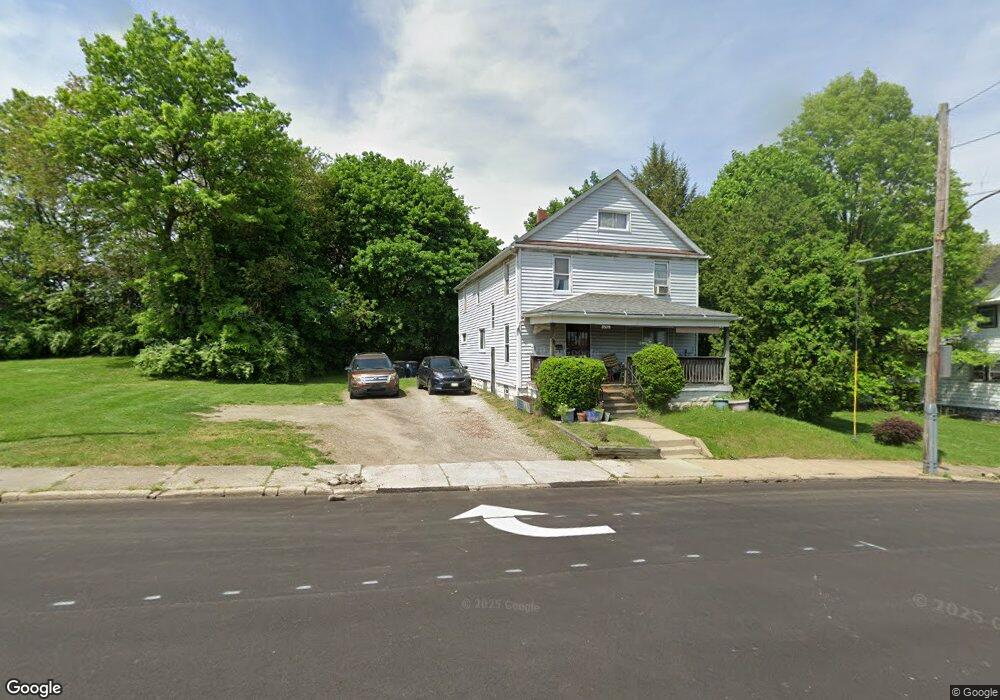
652 Rhodes Ave Akron, OH 44307
Sherbondy Hill NeighborhoodEstimated Value: $89,000 - $166,000
4
Beds
3
Baths
1,273
Sq Ft
$102/Sq Ft
Est. Value
About This Home
This home is located at 652 Rhodes Ave, Akron, OH 44307 and is currently estimated at $129,225, approximately $101 per square foot. 652 Rhodes Ave is a home located in Summit County with nearby schools including Towpath Trail High School, St. Vincent Elementary School, and St. Bernard-St. Mary Elementary School.
Ownership History
Date
Name
Owned For
Owner Type
Purchase Details
Closed on
Aug 16, 2006
Sold by
Edwards Jonathan K and Edwards Lisa A
Bought by
Owens Retsyn
Current Estimated Value
Home Financials for this Owner
Home Financials are based on the most recent Mortgage that was taken out on this home.
Original Mortgage
$63,000
Outstanding Balance
$42,008
Interest Rate
8.9%
Mortgage Type
Purchase Money Mortgage
Estimated Equity
$87,217
Purchase Details
Closed on
Jun 19, 2005
Sold by
Edwards John D and Edwards Victor K
Bought by
Edwards Jonathan K and Edwards Lisa A
Purchase Details
Closed on
Apr 22, 2005
Sold by
Estate Of Oliver D Edwards
Bought by
Edwards John D and Edwards Victor K
Purchase Details
Closed on
Sep 26, 2000
Sold by
Edwards Jonathan K
Bought by
Edwards Oliver D
Create a Home Valuation Report for This Property
The Home Valuation Report is an in-depth analysis detailing your home's value as well as a comparison with similar homes in the area
Home Values in the Area
Average Home Value in this Area
Purchase History
| Date | Buyer | Sale Price | Title Company |
|---|---|---|---|
| Owens Retsyn | $70,000 | Southeast Equity Title | |
| Edwards Jonathan K | -- | -- | |
| Edwards John D | -- | -- | |
| Edwards Oliver D | $7,500 | Minnesota Title Agency Inc |
Source: Public Records
Mortgage History
| Date | Status | Borrower | Loan Amount |
|---|---|---|---|
| Open | Owens Retsyn | $63,000 |
Source: Public Records
Tax History Compared to Growth
Tax History
| Year | Tax Paid | Tax Assessment Tax Assessment Total Assessment is a certain percentage of the fair market value that is determined by local assessors to be the total taxable value of land and additions on the property. | Land | Improvement |
|---|---|---|---|---|
| 2025 | $31,688 | $3,959 | $3,959 | -- |
| 2024 | $295 | $3,959 | $3,959 | -- |
| 2023 | $243 | $3,959 | $3,959 | -- |
| 2022 | $243 | $2,328 | $2,328 | $0 |
| 2021 | $243 | $2,328 | $2,328 | $0 |
| 2020 | $400 | $2,330 | $2,330 | $0 |
| 2019 | $515 | $3,550 | $3,550 | $0 |
| 2018 | $396 | $3,550 | $3,550 | $0 |
| 2017 | $630 | $3,550 | $3,550 | $0 |
| 2016 | $630 | $3,550 | $3,550 | $0 |
| 2015 | $630 | $3,550 | $3,550 | $0 |
| 2014 | $1,451 | $3,550 | $3,550 | $0 |
| 2013 | $1,932 | $15,620 | $3,550 | $12,070 |
Source: Public Records
Map
Nearby Homes
- 595 Rhodes Ave
- 577 Rhodes Ave
- 564 Euclid Ave
- 483 Bishop St
- 492 Douglas St
- 817 Raymond St
- 639 Bellevue Ave
- 670 Euclid Ave
- 385 Campbell St
- 794 Ruth Ave
- 644 Diagonal Rd
- 364 Campbell St
- 568 Auld Farm Cir
- 677 Vernon Odom Blvd
- 949 Raymond St
- 478 Copley Rd
- 524 Auld Farm Cir
- 686 East Ave
- 721 Vernon Odom Blvd
- 605 East Ave
- 656 Rhodes Ave
- 650 Rhodes Ave
- 648 Rhodes Ave
- 640 Rhodes Ave
- 636 Rhodes Ave
- 442 W Chestnut St
- 632 Rhodes Ave
- 450 W Chestnut St
- 641 Edgewood Ave
- 637 Edgewood Ave
- 633 Edgewood Ave
- 445 W Chestnut St
- 620 Rhodes Ave
- 447 W Chestnut St
- 616 Rhodes Ave
- 449 W Chestnut St
- 615 Edgewood Ave
- 612 Rhodes Ave
- 481 Euclid Ave
- 613 Edgewood Ave