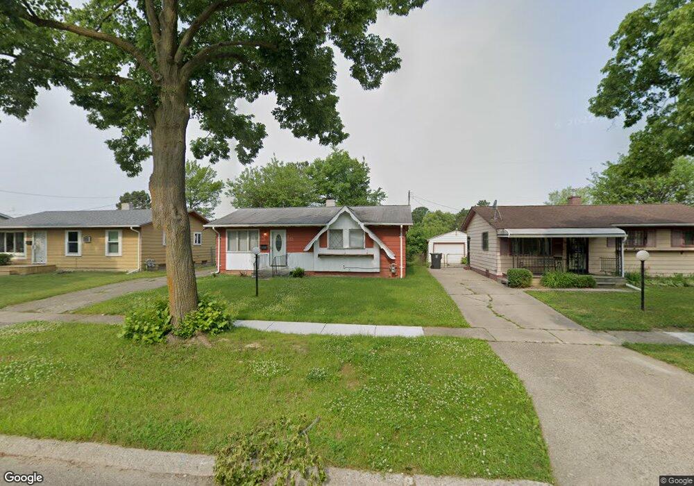
6521 Daryll Dr Flint, MI 48505
Brownell NeighborhoodEstimated Value: $47,000 - $65,000
3
Beds
2
Baths
942
Sq Ft
$60/Sq Ft
Est. Value
About This Home
This home is located at 6521 Daryll Dr, Flint, MI 48505 and is currently estimated at $56,581, approximately $60 per square foot. 6521 Daryll Dr is a home located in Genesee County with nearby schools including Brownell STEM Academy, The New Standard Academy, and Eagle's Nest Academy.
Ownership History
Date
Name
Owned For
Owner Type
Purchase Details
Closed on
Apr 22, 2005
Sold by
Fizer Harris A and Fizer Ruby
Bought by
Fizer Regina F
Current Estimated Value
Home Financials for this Owner
Home Financials are based on the most recent Mortgage that was taken out on this home.
Original Mortgage
$44,000
Outstanding Balance
$23,322
Interest Rate
6.2%
Mortgage Type
Fannie Mae Freddie Mac
Estimated Equity
$33,259
Purchase Details
Closed on
Apr 8, 2004
Sold by
Collins Arletha and Collins Joe
Bought by
Fizer Harris A and Fizer Regina F
Create a Home Valuation Report for This Property
The Home Valuation Report is an in-depth analysis detailing your home's value as well as a comparison with similar homes in the area
Home Values in the Area
Average Home Value in this Area
Purchase History
| Date | Buyer | Sale Price | Title Company |
|---|---|---|---|
| Fizer Regina F | -- | Title One Agency | |
| Fizer Harris A | $53,000 | Stewart Title Guaranty Compa |
Source: Public Records
Mortgage History
| Date | Status | Borrower | Loan Amount |
|---|---|---|---|
| Open | Fizer Regina F | $44,000 |
Source: Public Records
Tax History Compared to Growth
Tax History
| Year | Tax Paid | Tax Assessment Tax Assessment Total Assessment is a certain percentage of the fair market value that is determined by local assessors to be the total taxable value of land and additions on the property. | Land | Improvement |
|---|---|---|---|---|
| 2025 | $635 | $12,300 | $0 | $0 |
| 2024 | $587 | $9,400 | $0 | $0 |
| 2023 | $584 | $8,000 | $0 | $0 |
| 2022 | $0 | $6,300 | $0 | $0 |
| 2021 | $620 | $6,500 | $0 | $0 |
| 2020 | $628 | $7,600 | $0 | $0 |
| 2019 | $1,074 | $8,000 | $0 | $0 |
| 2018 | $665 | $8,600 | $0 | $0 |
| 2017 | $667 | $0 | $0 | $0 |
| 2016 | $699 | $0 | $0 | $0 |
| 2015 | -- | $0 | $0 | $0 |
| 2014 | -- | $0 | $0 | $0 |
| 2012 | -- | $13,100 | $0 | $0 |
Source: Public Records
Map
Nearby Homes
- 6610 Cranwood Dr
- 6702 Cranwood Dr
- 6914 Daryll Dr
- 613 W Foss Ave
- 6902 Sally Ct
- 614 W Holbrook Ave
- 605 W Foss Ave
- 618 W Austin Ave
- 6628 Orange Ln
- 6814 Colonial Dr
- 610 W Austin Ave
- 1015 W Carpenter Rd
- 525 W Bundy Ave
- 536 W Home Ave
- 405 W Lorado Ave
- 405 W Bundy Ave
- 1605 Barbara Dr
- 5714 Suburban Ct
- 1499 W Juliah Ave
- 5610 Baldwin Blvd
- 6525 Daryll Dr
- 6517 Daryll Dr
- 6601 Daryll Dr
- 6513 Daryll Dr
- 6605 Daryll Dr
- 6509 Daryll Dr
- 6522 Daryll Dr
- 6518 Daryll Dr
- 6526 Daryll Dr
- 6514 Daryll Dr
- 6602 Daryll Dr
- 6505 Daryll Dr
- 6510 Daryll Dr
- 6617 Daryll Dr
- 6611 Daryll Dr
- 6606 Daryll Dr
- 6621 Daryll Dr
- 6506 Daryll Dr
- 6625 Daryll Dr
- 6523 Cranwood Dr