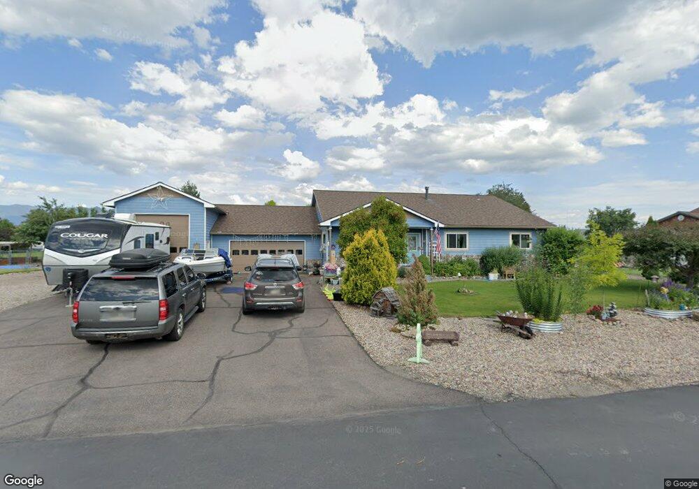
653 Rock Dr Kalispell, MT 59901
Estimated Value: $580,000 - $685,000
3
Beds
3
Baths
2,072
Sq Ft
$304/Sq Ft
Est. Value
About This Home
This home is located at 653 Rock Dr, Kalispell, MT 59901 and is currently estimated at $629,853, approximately $303 per square foot. 653 Rock Dr is a home located in Flathead County with nearby schools including Helena Flats Elementary School, Helena Flats Junior High School, and Glacier High School.
Ownership History
Date
Name
Owned For
Owner Type
Purchase Details
Closed on
Oct 6, 2010
Sold by
Fannie Mae
Bought by
Cowden Kenneth B and Cowden Darrissa M
Current Estimated Value
Home Financials for this Owner
Home Financials are based on the most recent Mortgage that was taken out on this home.
Original Mortgage
$215,380
Outstanding Balance
$141,621
Interest Rate
4.28%
Mortgage Type
VA
Estimated Equity
$488,232
Purchase Details
Closed on
Aug 9, 2010
Sold by
Burden Joseph A and Burden Angela R
Bought by
Federal National Mortgage Association
Home Financials for this Owner
Home Financials are based on the most recent Mortgage that was taken out on this home.
Original Mortgage
$215,380
Outstanding Balance
$141,621
Interest Rate
4.28%
Mortgage Type
VA
Estimated Equity
$488,232
Purchase Details
Closed on
Oct 28, 2005
Sold by
Tolman Merlon R and Tolman Jacqualine M
Bought by
Burden Joseph Adam and Burden Angela R
Create a Home Valuation Report for This Property
The Home Valuation Report is an in-depth analysis detailing your home's value as well as a comparison with similar homes in the area
Purchase History
| Date | Buyer | Sale Price | Title Company |
|---|---|---|---|
| Cowden Kenneth B | -- | First American Title Company | |
| Federal National Mortgage Association | $232,468 | First American Title Ins Co | |
| Burden Joseph Adam | -- | Alliance Title |
Source: Public Records
Mortgage History
| Date | Status | Borrower | Loan Amount |
|---|---|---|---|
| Open | Cowden Kenneth B | $215,380 |
Source: Public Records
Tax History
| Year | Tax Paid | Tax Assessment Tax Assessment Total Assessment is a certain percentage of the fair market value that is determined by local assessors to be the total taxable value of land and additions on the property. | Land | Improvement |
|---|---|---|---|---|
| 2025 | $2,831 | $610,300 | $0 | $0 |
| 2024 | $3,164 | $488,800 | $0 | $0 |
| 2023 | $3,965 | $488,800 | $0 | $0 |
| 2022 | $2,774 | $343,900 | $0 | $0 |
| 2021 | $3,020 | $343,900 | $0 | $0 |
| 2020 | $2,783 | $307,000 | $0 | $0 |
| 2019 | $2,750 | $307,000 | $0 | $0 |
| 2018 | $2,663 | $280,000 | $0 | $0 |
| 2017 | $2,706 | $280,000 | $0 | $0 |
| 2016 | $2,295 | $260,400 | $0 | $0 |
| 2015 | $2,407 | $260,400 | $0 | $0 |
| 2014 | $2,320 | $152,587 | $0 | $0 |
Source: Public Records
Map
Nearby Homes
- 3091 Elderberry Ave
- 1056 Clark Fork Dr
- 696 Mountain View Dr
- 111 Freedom Way Unit BARNDOMINIUM
- 791 Springwood Ln
- 112 Freedom Way
- 623 Saint Regis Dr
- 130 E Reserve Dr
- 132 Shadow Mountain Trail
- 164 Shadow Mountain Trail
- 148 Shadow Mountain Trail
- 518 Solberg Dr
- 1063 Harmony Ct
- 103 Spring Creek Dr
- 672 Shadow Ln
- 692 Shadow Ln
- 45 Mackin Ct
- 223 Cooperative Way
- 701 Addison Square
- 37 Mackin Ct
Your Personal Tour Guide
Ask me questions while you tour the home.