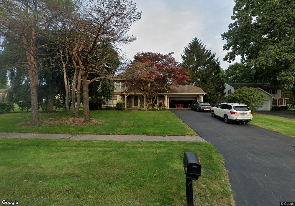
654 Watson Rd Fairport, NY 14450
Estimated Value: $311,000 - $376,000
3
Beds
3
Baths
1,832
Sq Ft
$192/Sq Ft
Est. Value
About This Home
This home is located at 654 Watson Rd, Fairport, NY 14450 and is currently estimated at $351,447, approximately $191 per square foot. 654 Watson Rd is a home located in Monroe County with nearby schools including Northside School, Dudley School, and Johanna Perrin Middle School.
Ownership History
Date
Name
Owned For
Owner Type
Purchase Details
Closed on
May 31, 2024
Sold by
Tierson Shelley V
Bought by
Tierson Shelley V and Tierson Jayson W
Current Estimated Value
Purchase Details
Closed on
Dec 3, 2009
Sold by
Sereika Ronald A and Angelone Julie
Bought by
Tierson Shelley
Home Financials for this Owner
Home Financials are based on the most recent Mortgage that was taken out on this home.
Original Mortgage
$155,680
Interest Rate
5.37%
Mortgage Type
FHA
Purchase Details
Closed on
Aug 5, 2009
Sold by
Sereika Ronald A
Bought by
Sereika Ronald A and Angelone Julie
Purchase Details
Closed on
Dec 15, 2002
Sold by
Sereika Ronald A
Bought by
Sereika Ronald A
Create a Home Valuation Report for This Property
The Home Valuation Report is an in-depth analysis detailing your home's value as well as a comparison with similar homes in the area
Home Values in the Area
Average Home Value in this Area
Purchase History
| Date | Buyer | Sale Price | Title Company |
|---|---|---|---|
| Tierson Shelley V | -- | None Listed On Document | |
| Tierson Shelley | $158,600 | None Available | |
| Sereika Ronald A | -- | None Available | |
| Sereika Ronald A | -- | -- |
Source: Public Records
Mortgage History
| Date | Status | Borrower | Loan Amount |
|---|---|---|---|
| Previous Owner | Tierson Shelley | $155,680 |
Source: Public Records
Tax History Compared to Growth
Tax History
| Year | Tax Paid | Tax Assessment Tax Assessment Total Assessment is a certain percentage of the fair market value that is determined by local assessors to be the total taxable value of land and additions on the property. | Land | Improvement |
|---|---|---|---|---|
| 2024 | $6,341 | $173,700 | $44,300 | $129,400 |
| 2023 | $6,075 | $173,700 | $44,300 | $129,400 |
| 2022 | $6,469 | $173,700 | $44,300 | $129,400 |
| 2021 | $6,476 | $173,700 | $44,300 | $129,400 |
| 2020 | $5,663 | $173,700 | $44,300 | $129,400 |
| 2019 | $5,204 | $173,700 | $44,300 | $129,400 |
| 2018 | $5,466 | $173,700 | $44,300 | $129,400 |
| 2017 | $3,140 | $160,800 | $44,300 | $116,500 |
| 2016 | $5,204 | $160,800 | $44,300 | $116,500 |
| 2015 | -- | $160,800 | $44,300 | $116,500 |
| 2014 | -- | $160,800 | $44,300 | $116,500 |
Source: Public Records
Map
Nearby Homes
- 15 Whitney Farms Cir
- 603 Watson Rd
- 19 Homestead Dr
- 1331 Whitney Rd E
- 70 High St
- 12 Deland Park A
- 86 Broxbourne Dr
- 2 Foxpointe Cir
- 255 Watson Rd
- 105 Packetts Glen
- 3 Packetts Glen
- 79 Saint Andrews Blvd
- 9 Killeen Dr
- 3 Acadian Rise
- 4 Arbor Ct
- 30 Cali Ridge
- 14 Little Briggins Cir
- 76 - 78 Summit St
- 34 Belinda Crescent
- 31 Belinda Crescent
- 658 Watson Rd
- 17 Whitney Farms Cir
- 19 Whitney Farms Cir
- 651 Watson Rd
- 643 Watson Rd
- 1220 Whitney Rd E
- 20 Whitney Farms Cir
- 635 Watson Rd
- 11 Whitney Farms Cir
- 660 Turk Hill Rd
- 1201 Whitney Rd E
- 1172 Whitney Rd E
- 18 Whitney Farms Cir
- 1215 Whitney Rd E
- 627 Watson Rd
- 1181 Whitney Rd E
- 9 Whitney Farms Cir
- 16 Whitney Farms Cir
- 1164 Whitney Rd E
- 6 Rockford Ln