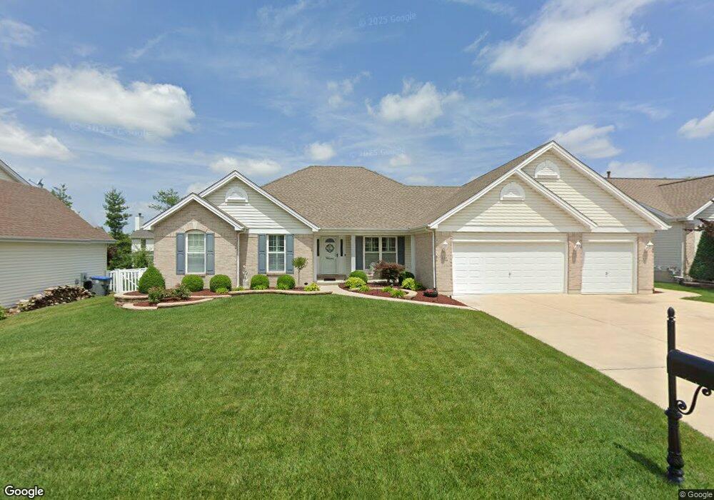
655 Logan Valley Dr Saint Peters, MO 63376
Estimated Value: $468,427 - $507,000
3
Beds
3
Baths
2,228
Sq Ft
$218/Sq Ft
Est. Value
About This Home
This home is located at 655 Logan Valley Dr, Saint Peters, MO 63376 and is currently estimated at $486,357, approximately $218 per square foot. 655 Logan Valley Dr is a home located in St. Charles County with nearby schools including Progress South Elementary School, Fort Zumwalt South Middle School, and Fort Zumwalt South High School.
Ownership History
Date
Name
Owned For
Owner Type
Purchase Details
Closed on
Aug 9, 2001
Sold by
Tom Johnson Construction Company Inc
Bought by
Connoley Timothy W and Connoley Cynthia L
Current Estimated Value
Home Financials for this Owner
Home Financials are based on the most recent Mortgage that was taken out on this home.
Original Mortgage
$172,000
Outstanding Balance
$67,143
Interest Rate
7.16%
Estimated Equity
$419,214
Create a Home Valuation Report for This Property
The Home Valuation Report is an in-depth analysis detailing your home's value as well as a comparison with similar homes in the area
Home Values in the Area
Average Home Value in this Area
Purchase History
| Date | Buyer | Sale Price | Title Company |
|---|---|---|---|
| Connoley Timothy W | $221,853 | -- |
Source: Public Records
Mortgage History
| Date | Status | Borrower | Loan Amount |
|---|---|---|---|
| Open | Connoley Timothy W | $172,000 |
Source: Public Records
Tax History Compared to Growth
Tax History
| Year | Tax Paid | Tax Assessment Tax Assessment Total Assessment is a certain percentage of the fair market value that is determined by local assessors to be the total taxable value of land and additions on the property. | Land | Improvement |
|---|---|---|---|---|
| 2025 | $5,121 | $83,459 | -- | -- |
| 2023 | $5,123 | $77,617 | $0 | $0 |
| 2022 | $4,915 | $69,296 | $0 | $0 |
| 2021 | $4,876 | $68,685 | $0 | $0 |
| 2020 | $4,737 | $64,591 | $0 | $0 |
| 2019 | $4,748 | $64,591 | $0 | $0 |
| 2018 | $4,370 | $56,739 | $0 | $0 |
| 2017 | $4,323 | $56,739 | $0 | $0 |
| 2016 | $3,758 | $49,118 | $0 | $0 |
| 2015 | $3,493 | $49,118 | $0 | $0 |
| 2014 | $3,391 | $46,880 | $0 | $0 |
Source: Public Records
Map
Nearby Homes
- 25 Broad Brook Ct
- 1803 Jacobs Cir
- 136 Jacobs Way
- 1 Pauley Cir
- 179 Christina Marie Dr
- 178 Christina Marie Dr
- 6420 Long Timber Dr
- 219 Braddock Way
- 2737 Red Cedar Parc Dr S
- 93 Arapahoe Basin Ct
- 367 Shamrock St
- 361 Shamrock St
- 86 Myrtle Wood Ct
- 211 Butternut Stage Dr
- 41 Pheasant Ring Dr
- 5 Arborgate Dr Unit 69A
- 6 Covered Wagon Trail Ct
- 2 the Durango at the Grove
- 34 Pheasant Ring Dr
- 2136 Farnsworth Dr Unit D
- 651 Logan Valley Dr
- 659 Logan Valley Dr
- 1032 Summersweet Dr
- 1028 Summersweet Dr
- 1036 Summersweet Dr
- 647 Logan Valley Dr
- 656 Logan Valley Dr
- 1024 Summersweet Dr
- 652 Logan Valley Dr
- 660 Logan Valley Dr
- 648 Logan Valley Dr
- 667 Logan Valley Dr
- 641 Logan Valley Dr
- 664 Logan Valley Dr
- 905 Oxford Trail Dr
- 1020 Summersweet Dr
- 1117 Meadowsweet Dr
- 644 Logan Valley Dr
- 1035 Summersweet Dr
- 668 Logan Valley Dr