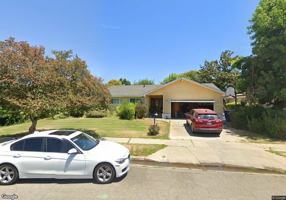
6550 N Roosevelt Ave Fresno, CA 93704
Bullard NeighborhoodEstimated Value: $354,000 - $528,000
4
Beds
2
Baths
1,880
Sq Ft
$237/Sq Ft
Est. Value
About This Home
This home is located at 6550 N Roosevelt Ave, Fresno, CA 93704 and is currently estimated at $445,418, approximately $236 per square foot. 6550 N Roosevelt Ave is a home located in Fresno County with nearby schools including Kratt Elementary School, Tenaya Middle School, and Bullard High School.
Ownership History
Date
Name
Owned For
Owner Type
Purchase Details
Closed on
May 1, 2020
Sold by
Gilbert Tama T and Tocchio Maria
Bought by
Tocchio Maria and Meindersee Morgan
Current Estimated Value
Purchase Details
Closed on
Aug 18, 2010
Sold by
Tocchio Octavio J and Tocchio Marion P
Bought by
Tocchio Octavio J and Tocchio Marion P
Create a Home Valuation Report for This Property
The Home Valuation Report is an in-depth analysis detailing your home's value as well as a comparison with similar homes in the area
Home Values in the Area
Average Home Value in this Area
Purchase History
| Date | Buyer | Sale Price | Title Company |
|---|---|---|---|
| Tocchio Maria | $127,500 | Chicago Title | |
| Tocchio Octavio J | -- | None Available |
Source: Public Records
Tax History Compared to Growth
Tax History
| Year | Tax Paid | Tax Assessment Tax Assessment Total Assessment is a certain percentage of the fair market value that is determined by local assessors to be the total taxable value of land and additions on the property. | Land | Improvement |
|---|---|---|---|---|
| 2025 | $3,386 | $113,146 | $19,603 | $93,543 |
| 2023 | $3,386 | $206,795 | $51,468 | $155,327 |
| 2022 | $2,552 | $202,741 | $50,459 | $152,282 |
| 2021 | $2,482 | $198,767 | $49,470 | $149,297 |
| 2020 | $1,229 | $103,457 | $17,926 | $85,531 |
| 2019 | $1,180 | $101,429 | $17,575 | $83,854 |
| 2018 | $1,153 | $99,441 | $17,231 | $82,210 |
| 2017 | $1,132 | $97,493 | $16,894 | $80,599 |
| 2016 | $1,094 | $95,582 | $16,563 | $79,019 |
| 2015 | $1,076 | $94,148 | $16,315 | $77,833 |
| 2014 | $1,055 | $92,305 | $15,996 | $76,309 |
Source: Public Records
Map
Nearby Homes
- 744 W Palo Altp Ave
- 6607 N Maroa Ave
- 744 W Magill Ave
- 6300 N Palm Ave Unit 125
- 6300 N Palm Ave Unit 105
- 6265 N Colonial Ave
- 6338 N Maroa Ave Unit 115
- 6260 N Palm Ave Unit 111
- 353 W Warner Ave
- 355 W Sierra Ave Unit 106
- 1 Palm Ave
- 1041 W Sierra Ave
- 7013 N Maroa Ave
- 317 W Sierra Ave Unit 124
- 317 W Sierra Ave Unit 107
- 317 W Sierra Ave Unit 125
- 411 W Vartikian Ave
- 671 W Sample Ave
- 221 W Herndon Ave Unit 130
- 221 W Herndon Ave Unit 49
- 6540 N Roosevelt Ave
- 625 W Palo Alto Ave
- 6537 N Colonial Ave
- 605 W Palo Alto Ave
- 6527 N Colonial Ave
- 6547 N Colonial Ave
- 6530 N Roosevelt Ave
- 6549 N Roosevelt Ave
- 6517 N Colonial Ave
- 643 W Palo Alto Ave
- 6535 N Roosevelt Ave
- 591 W Palo Alto Ave
- 6520 N Roosevelt Ave
- 6507 N Colonial Ave
- 672 W Paul Ave
- 616 W Palo Alto Ave
- 626 W Palo Alto Ave
- 665 W Palo Alto Ave
- 6520 N Colonial Ave
- 604 W Palo Alto Ave