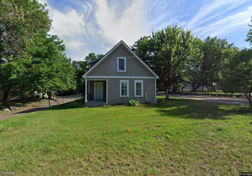
6553 Cedar St North Branch, MN 55056
Estimated Value: $272,691 - $285,000
3
Beds
2
Baths
1,713
Sq Ft
$162/Sq Ft
Est. Value
About This Home
This home is located at 6553 Cedar St, North Branch, MN 55056 and is currently estimated at $277,897, approximately $162 per square foot. 6553 Cedar St is a home located in Chisago County with nearby schools including North Branch Middle School, Sunrise River Elementary School, and North Branch Senior High School.
Ownership History
Date
Name
Owned For
Owner Type
Purchase Details
Closed on
Jul 22, 2020
Sold by
Polar Const Llc
Bought by
Prantner Jaymie A
Current Estimated Value
Purchase Details
Closed on
Feb 18, 2020
Home Financials for this Owner
Home Financials are based on the most recent Mortgage that was taken out on this home.
Original Mortgage
$44,000
Interest Rate
3.47%
Purchase Details
Closed on
Apr 6, 2001
Sold by
The Provident Bank
Bought by
Gt Properties Llp
Purchase Details
Closed on
Oct 27, 1997
Sold by
Olson Leon R
Bought by
Pedersen Kelly D
Create a Home Valuation Report for This Property
The Home Valuation Report is an in-depth analysis detailing your home's value as well as a comparison with similar homes in the area
Home Values in the Area
Average Home Value in this Area
Purchase History
| Date | Buyer | Sale Price | Title Company |
|---|---|---|---|
| Prantner Jaymie A | $197,500 | -- | |
| -- | $54,000 | -- | |
| Gt Properties Llp | $69,000 | -- | |
| Pedersen Kelly D | $40,300 | -- |
Source: Public Records
Mortgage History
| Date | Status | Borrower | Loan Amount |
|---|---|---|---|
| Previous Owner | -- | $44,000 | |
| Previous Owner | -- | -- | |
| Closed | Pedersen Kelly D | -- |
Source: Public Records
Tax History
| Year | Tax Paid | Tax Assessment Tax Assessment Total Assessment is a certain percentage of the fair market value that is determined by local assessors to be the total taxable value of land and additions on the property. | Land | Improvement |
|---|---|---|---|---|
| 2024 | $2,754 | $209,400 | $0 | $0 |
| 2023 | $2,754 | $231,800 | $0 | $0 |
| 2022 | $2,610 | $212,300 | $0 | $0 |
| 2021 | $728 | $170,800 | $0 | $0 |
| 2020 | $1,118 | $72,500 | $40,000 | $32,500 |
| 2019 | $1,128 | $0 | $0 | $0 |
| 2018 | $1,072 | $0 | $0 | $0 |
| 2017 | $1,082 | $0 | $0 | $0 |
| 2016 | $1,122 | $0 | $0 | $0 |
| 2015 | $1,028 | $0 | $0 | $0 |
| 2014 | -- | $45,800 | $0 | $0 |
Source: Public Records
Map
Nearby Homes
- 39094 Riverside Ct
- XXXXX Maple St
- 38624 Grand Ave
- TBD Ash St
- 38558 Grand Ave
- 38820 Maple Ct
- 6119 Red Fox Run
- 524X 391st St
- 38xxx Oakview Ave
- TBD Saint Croix Trail
- 38639 Hawthorne Ave
- 7255 Hawthorne Ct
- 7268 Hawthorne Ct
- 7222 Hawthorne Ct
- 7246 385th St
- 38280 Great Oaks Ct
- 5187 391st St
- 5128 391st St
- 5276 391st St
- 5156 391st St
Your Personal Tour Guide
Ask me questions while you tour the home.