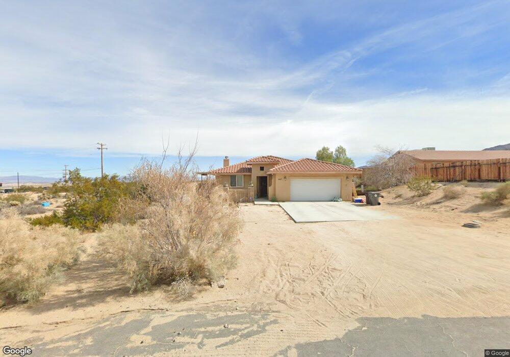
6557 Indian Cir Twentynine Palms, CA 92277
Estimated Value: $319,153 - $397,000
3
Beds
2
Baths
1,759
Sq Ft
$204/Sq Ft
Est. Value
About This Home
This home is located at 6557 Indian Cir, Twentynine Palms, CA 92277 and is currently estimated at $358,038, approximately $203 per square foot. 6557 Indian Cir is a home located in San Bernardino County with nearby schools including Oasis Elementary School, Twentynine Palms Junior High School, and Twentynine Palms High School.
Ownership History
Date
Name
Owned For
Owner Type
Purchase Details
Closed on
Feb 4, 2022
Sold by
Love Leslie Y R
Bought by
Leslie Love Living Trust
Current Estimated Value
Purchase Details
Closed on
Oct 16, 2012
Sold by
Delon Michele
Bought by
Love Leslie Y R
Purchase Details
Closed on
Jul 18, 2002
Sold by
Rarick Jack
Bought by
Delon Michele
Create a Home Valuation Report for This Property
The Home Valuation Report is an in-depth analysis detailing your home's value as well as a comparison with similar homes in the area
Home Values in the Area
Average Home Value in this Area
Purchase History
| Date | Buyer | Sale Price | Title Company |
|---|---|---|---|
| Leslie Love Living Trust | -- | Dkn Legal Pllc | |
| Love Leslie Y R | $160,000 | Fidelity National Title | |
| Delon Michele | $900 | -- |
Source: Public Records
Tax History Compared to Growth
Tax History
| Year | Tax Paid | Tax Assessment Tax Assessment Total Assessment is a certain percentage of the fair market value that is determined by local assessors to be the total taxable value of land and additions on the property. | Land | Improvement |
|---|---|---|---|---|
| 2025 | $2,558 | $197,029 | $19,703 | $177,326 |
| 2024 | $2,558 | $193,166 | $19,317 | $173,849 |
| 2023 | $2,477 | $189,378 | $18,938 | $170,440 |
| 2022 | $2,422 | $185,665 | $18,567 | $167,098 |
| 2021 | $2,394 | $182,025 | $18,203 | $163,822 |
| 2020 | $2,370 | $180,158 | $18,016 | $162,142 |
| 2019 | $2,312 | $176,626 | $17,663 | $158,963 |
| 2018 | $2,257 | $173,163 | $17,317 | $155,846 |
| 2017 | $2,231 | $169,767 | $16,977 | $152,790 |
| 2016 | $2,115 | $166,438 | $16,644 | $149,794 |
| 2015 | $2,222 | $163,938 | $16,394 | $147,544 |
| 2014 | $2,207 | $160,727 | $16,073 | $144,654 |
Source: Public Records
Map
Nearby Homes
- 207 Indian Cir
- 69235 Old Dale Rd
- 6425 Indian Cove Rd
- 6548 Quail Spring Ave
- 6646 Quail Spring Ave
- 111 S 29 Palms Outer Hwy
- 0 Ivanpah Ave Unit CV25172617
- 6789 Copper Mountain Rd
- 5440 Shoshone Valley Rd
- 5400 Shoshone Valley Rd
- 11 Indian Cove Rd
- 12 Indian Cove Rd
- 70138 Sullivan Rd
- 0 Sheridan Rd Unit OC23054129
- 0 Mantonya Rd Unit WS25144506
- 6344 Timothy Ave
- 2.5 Acres On Hwy 62 Near Kern Blvd
- 6424 Canyon Rd
- 6378 Canyon Rd
- 68054 Sullivan Rd
- 6557 Indian Cir
- 69272 Cactus Dr
- 69268 Cactus Dr
- 1 Indian Cir
- 2 Indian Cir
- 0 Indian Cir Unit DC21131952
- 0 Indian Cir Unit DC21131954
- 0 Indian Cir Unit DC11162656
- 0 Indian Cir Unit DC11162653
- 0 Indian Cir Unit 41392412
- 0 Indian Cir Unit 41392431
- 0 Indian Cir Unit 13-706423PS
- 0 Indian Cir Unit 13706423DA
- 0 Indian Cir Unit 13706367DA
- 206 Indian Cir
- 6578 Indian Cir
- 69288 Cactus Dr
- 69289 Twentynine Palms Hwy
- 69289 29 Palms Hwy
- 0 0614102200000 Outer 29 Palms Hwy Unit 22004320