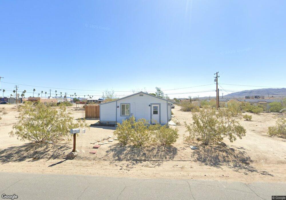
6557 Split Rock Ave Twentynine Palms, CA 92277
Estimated Value: $113,526 - $229,000
1
Bed
2
Baths
564
Sq Ft
$301/Sq Ft
Est. Value
About This Home
This home is located at 6557 Split Rock Ave, Twentynine Palms, CA 92277 and is currently estimated at $169,882, approximately $301 per square foot. 6557 Split Rock Ave is a home located in San Bernardino County with nearby schools including Palm Vista Elementary School, Twentynine Palms Junior High School, and Twentynine Palms High School.
Ownership History
Date
Name
Owned For
Owner Type
Purchase Details
Closed on
May 31, 2018
Sold by
Hopkins Patricia M
Bought by
Hopkins Patricia M and Patricia M Hopkins Trust
Current Estimated Value
Purchase Details
Closed on
Mar 9, 1996
Sold by
Ramirez Manuel R
Bought by
Berg Roger E
Home Financials for this Owner
Home Financials are based on the most recent Mortgage that was taken out on this home.
Original Mortgage
$15,000
Outstanding Balance
$586
Interest Rate
6.98%
Mortgage Type
Seller Take Back
Estimated Equity
$169,296
Create a Home Valuation Report for This Property
The Home Valuation Report is an in-depth analysis detailing your home's value as well as a comparison with similar homes in the area
Home Values in the Area
Average Home Value in this Area
Purchase History
| Date | Buyer | Sale Price | Title Company |
|---|---|---|---|
| Hopkins Patricia M | -- | None Available | |
| Berg Roger E | $15,000 | -- |
Source: Public Records
Mortgage History
| Date | Status | Borrower | Loan Amount |
|---|---|---|---|
| Open | Berg Roger E | $15,000 |
Source: Public Records
Tax History
| Year | Tax Paid | Tax Assessment Tax Assessment Total Assessment is a certain percentage of the fair market value that is determined by local assessors to be the total taxable value of land and additions on the property. | Land | Improvement |
|---|---|---|---|---|
| 2025 | $836 | $24,860 | $9,470 | $15,390 |
| 2024 | $783 | $24,372 | $9,284 | $15,088 |
| 2023 | $737 | $23,894 | $9,102 | $14,792 |
| 2022 | $717 | $23,426 | $8,924 | $14,502 |
| 2021 | $707 | $22,967 | $8,749 | $14,218 |
| 2020 | $694 | $22,731 | $8,659 | $14,072 |
| 2019 | $663 | $22,285 | $8,489 | $13,796 |
| 2018 | $649 | $21,848 | $8,323 | $13,525 |
| 2017 | $563 | $21,469 | $5,724 | $15,745 |
| 2016 | $551 | $21,048 | $5,612 | $15,436 |
| 2015 | $476 | $20,732 | $5,528 | $15,204 |
| 2014 | $472 | $20,326 | $5,420 | $14,906 |
Source: Public Records
Map
Nearby Homes
- 6600 Split Rock Ave
- 0 Desert Queen Ave Unit IG26071588
- 800 Desert Queen Ave
- 73478 Old Dale Rd
- 6688 Oasis Ave
- 6444 Tamarisk Ave
- 0 Pine Ave Unit DW24138946
- 6572 Bullion Ave
- 69538 Jim Pine
- 6367 Split Rock Ave
- 6526 Hillside Ave
- 777 Hillside Ave
- 73289 Twentynine Palms
- 6666 Cholla Ave
- 6646 Cholla Ave
- 0 None Ave Unit IV26010640
- 0 None Ave Unit IV26010666
- 0 None Ave Unit IV26010677
- 0 None Ave Unit IV26015200
- 0 None Ave Unit IV26010670
- 6568 Desert Queen Ave
- 6580 Desert Queen Ave
- 6585 Split Rock Ave
- 6552 Split Rock Ave
- 6536 Desert Queen Ave Unit 38
- 6582 Split Rock Ave
- 6588 Split Rock Ave
- 6563 Desert Queen Ave
- 6583 Oasis Ave
- 1 Split Rock Ave
- 2 Split Rock Ave
- 6530 Split Rock Ave
- 6577 Desert Queen Ave
- 6587 Oasis Ave
- 6587 Oasis Ave Unit B
- 6587 Oasis Ave
- 6547 Desert Queen Ave
- 6591 Desert Queen Ave
- 73455 29 Palms Hwy
- 6553 Desert Queen Ave Unit 6555
Your Personal Tour Guide
Ask me questions while you tour the home.