
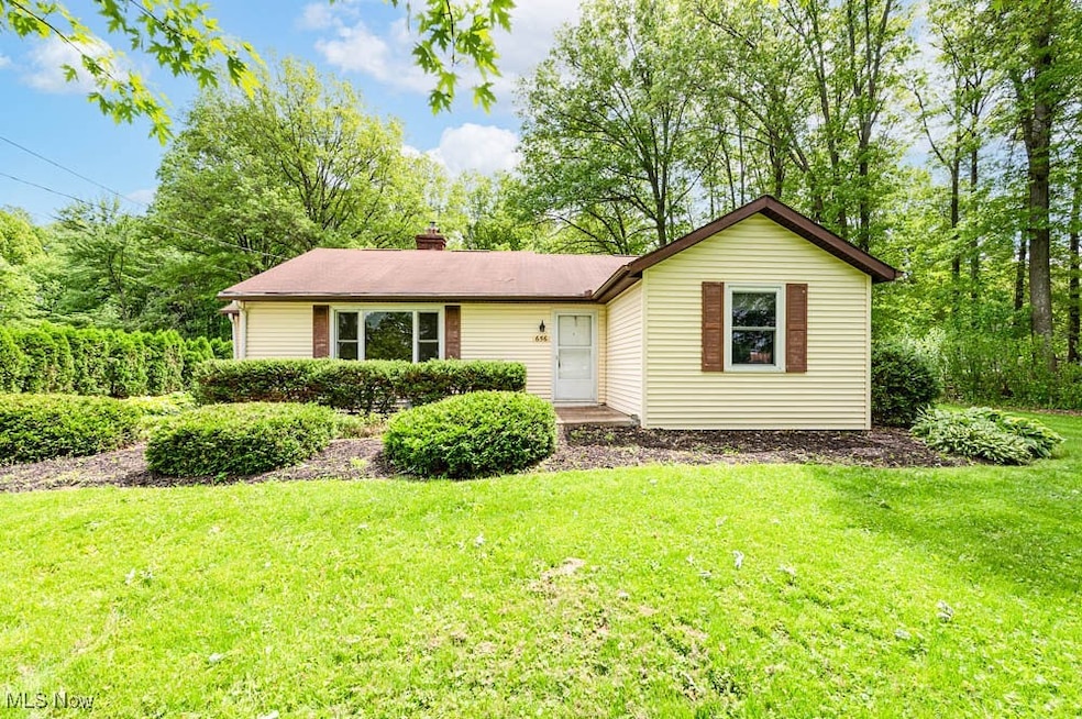
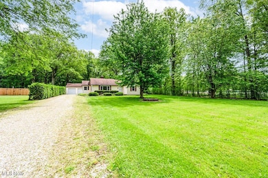
656 N 12th St Sebring, OH 44672
Estimated payment $1,180/month
Total Views
7,455
3
Beds
1.5
Baths
1,364
Sq Ft
$136
Price per Sq Ft
Highlights
- Views of Trees
- Deck
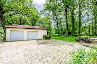
- 4 Car Detached Garage
- 0.77 Acre Lot
- No HOA
- Hot Water Heating System
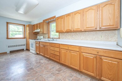
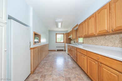
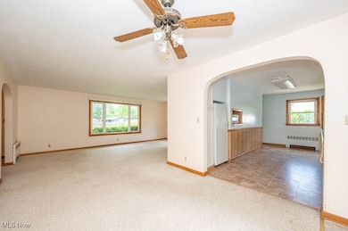
About This Home
Charming Mid-Century Ranch on a Beautiful .77 Acre Lot!
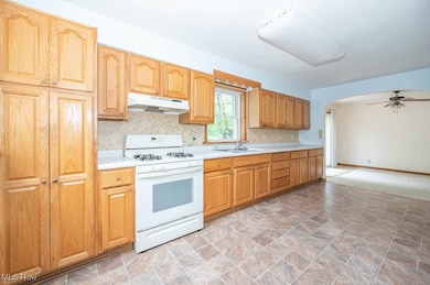
Tucked on a lush and private parcel, this 3 bedroom, 1.5 bath ranch offers over 1,364 sq ft of potential and personality. Enjoy spacious living areas filled with natural light, a dining area with sliders to the backyard, and a kitchen with a pantry that could easily convert to a convenient first-floor laundry. The full walk-out basement features a partial bath and room for a canning kitchen, workshop and more. Need garage space? You’ll love the 30x32 garage—ideal for vehicles, workshop, or storage galore. Step outside to a wooded backyard oasis complete with a firepit, perfect for fall nights and summer BBQs. And with a front row seat to the local football, track and baseball action, this home blends small-town charm with daily convenience. Don’t miss the opportunity to make this gem your own!
Listing Agent
Howard Hanna Brokerage Email: clautzenheiser@howardhanna.com 330-565-3712 License #449022 Listed on: 05/20/2025
Home Details
Home Type
- Single Family
Est. Annual Taxes
- $1,906
Year Built
- Built in 1950
Parking
- 4 Car Detached Garage
- No Garage
- Driveway
- Unpaved Parking
Home Design
- Asphalt Roof
- Vinyl Siding
Interior Spaces
- 1,364 Sq Ft Home
- 1-Story Property
- Views of Trees
- Range
Bedrooms and Bathrooms
- 3 Main Level Bedrooms
- 1.5 Bathrooms
Basement
- Basement Fills Entire Space Under The House
- Sump Pump
Utilities
- No Cooling
- Heating System Uses Gas
- Hot Water Heating System
Additional Features
- Deck
- 0.77 Acre Lot
Community Details
- No Home Owners Association
- Sebring Subdivision
Listing and Financial Details
- Assessor Parcel Number 21-0140003
Map
Create a Home Valuation Report for This Property
The Home Valuation Report is an in-depth analysis detailing your home's value as well as a comparison with similar homes in the area
Home Values in the Area
Average Home Value in this Area
Tax History
| Year | Tax Paid | Tax Assessment Tax Assessment Total Assessment is a certain percentage of the fair market value that is determined by local assessors to be the total taxable value of land and additions on the property. | Land | Improvement |
|---|---|---|---|---|
| 2024 | $1,501 | $46,000 | $6,250 | $39,750 |
| 2023 | $1,427 | $46,000 | $6,250 | $39,750 |
| 2022 | $906 | $30,770 | $6,250 | $24,520 |
| 2021 | $873 | $30,770 | $6,250 | $24,520 |
| 2020 | $929 | $30,770 | $6,250 | $24,520 |
| 2019 | $844 | $27,030 | $6,250 | $20,780 |
| 2018 | $828 | $27,030 | $6,250 | $20,780 |
| 2017 | $825 | $27,030 | $6,250 | $20,780 |
| 2016 | $800 | $26,650 | $5,620 | $21,030 |
| 2015 | $777 | $26,650 | $5,620 | $21,030 |
| 2014 | -- | $26,650 | $5,620 | $21,030 |
| 2013 | $792 | $26,650 | $5,620 | $21,030 |
Source: Public Records
Property History
| Date | Event | Price | Change | Sq Ft Price |
|---|---|---|---|---|
| 06/16/2025 06/16/25 | Pending | -- | -- | -- |
| 05/20/2025 05/20/25 | For Sale | $184,900 | -- | $136 / Sq Ft |
Source: MLS Now (Howard Hanna)
Purchase History
| Date | Type | Sale Price | Title Company |
|---|---|---|---|
| Joint Tenancy Deed | $48,900 | -- | |
| Deed | -- | -- |
Source: Public Records
Mortgage History
| Date | Status | Loan Amount | Loan Type |
|---|---|---|---|
| Previous Owner | $85,000 | Credit Line Revolving | |
| Previous Owner | $39,100 | No Value Available |
Source: Public Records
Similar Homes in Sebring, OH
Source: MLS Now (Howard Hanna)
MLS Number: 5123577
APN: 21-014-0-003.00-0
Disclaimer: Certain information contained herein is derived from information provided by parties other than Homes.com. All information provided is deemed reliable, but is not guaranteed to be accurate and should be independently verified.
![]() Certain information contained herein is derived from information provided by parties other than Homes.com. All information provided is deemed reliable, but is not guaranteed to be accurate and should be independently verified.
Certain information contained herein is derived from information provided by parties other than Homes.com. All information provided is deemed reliable, but is not guaranteed to be accurate and should be independently verified.
Nearby Homes
- 316 1/2 E Vermont Ave
- 355 N 12th St
- 215 E Virginia Ave
- 206 E Maryland Ave
- 756 N 15th St
- 555 N 16th St
- 175 W Ohio Ave
- 265 W Maryland Ave
- 325 W Maryland Ave
- 455 E Florida Ave
- 406 W Indiana Ave
- 0 W Maryland Ave
- 240 S 15th St
- 0 E Texas Ave
- 495 W Ohio Ave
- 226 N 19th St
- 335 W New York Ave
- 439 S 15th St
- 608 S 14th St
- 489 W Georgia Ave