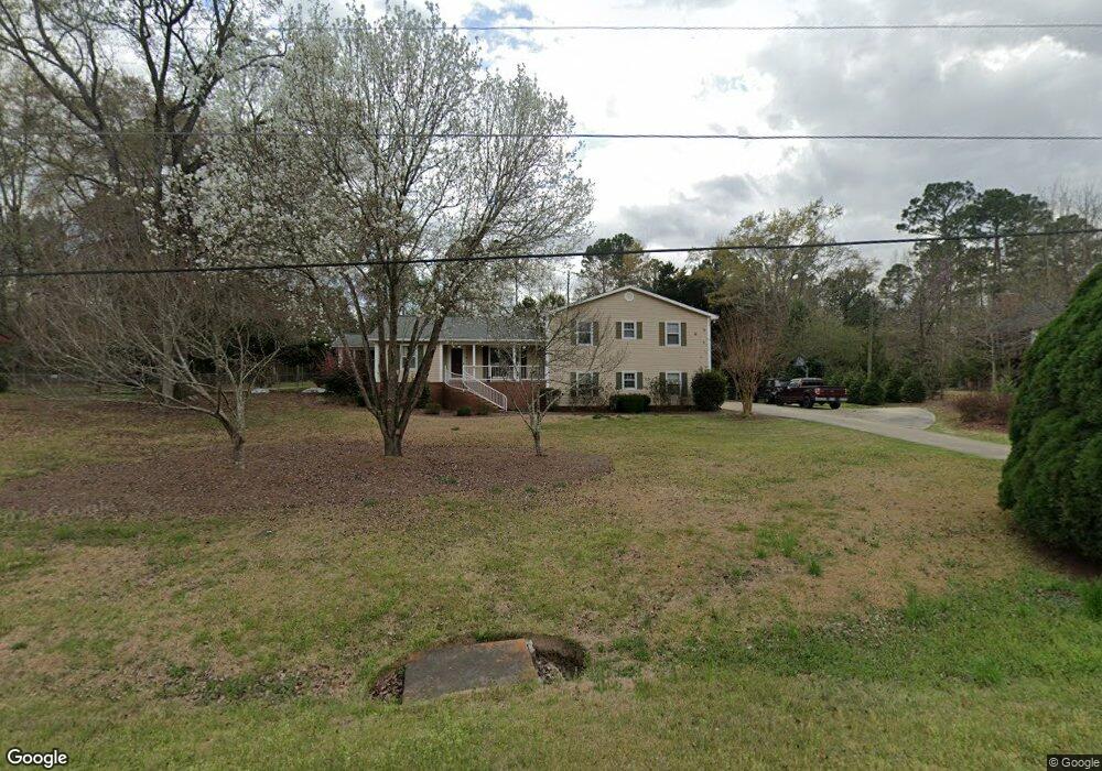
6561 Chriswood Dr Macon, GA 31216
Estimated Value: $232,000 - $286,000
4
Beds
2
Baths
2,332
Sq Ft
$116/Sq Ft
Est. Value
About This Home
This home is located at 6561 Chriswood Dr, Macon, GA 31216 and is currently estimated at $269,948, approximately $115 per square foot. 6561 Chriswood Dr is a home located in Bibb County with nearby schools including Heard Elementary School, Rutland Middle School, and Rutland High School.
Ownership History
Date
Name
Owned For
Owner Type
Purchase Details
Closed on
Apr 20, 2005
Sold by
Hawthorne Bonnie T
Bought by
Hajworonsky Michael G
Current Estimated Value
Home Financials for this Owner
Home Financials are based on the most recent Mortgage that was taken out on this home.
Original Mortgage
$196,400
Outstanding Balance
$101,345
Interest Rate
5.88%
Mortgage Type
New Conventional
Estimated Equity
$168,603
Create a Home Valuation Report for This Property
The Home Valuation Report is an in-depth analysis detailing your home's value as well as a comparison with similar homes in the area
Home Values in the Area
Average Home Value in this Area
Purchase History
| Date | Buyer | Sale Price | Title Company |
|---|---|---|---|
| Hajworonsky Michael G | $196,400 | None Avilebel |
Source: Public Records
Mortgage History
| Date | Status | Borrower | Loan Amount |
|---|---|---|---|
| Open | Hajworonsky Michael G | $196,400 |
Source: Public Records
Tax History Compared to Growth
Tax History
| Year | Tax Paid | Tax Assessment Tax Assessment Total Assessment is a certain percentage of the fair market value that is determined by local assessors to be the total taxable value of land and additions on the property. | Land | Improvement |
|---|---|---|---|---|
| 2025 | $2,145 | $94,306 | $13,580 | $80,726 |
| 2024 | $2,215 | $94,228 | $13,580 | $80,648 |
| 2023 | $1,585 | $87,413 | $13,580 | $73,833 |
| 2022 | $2,946 | $92,106 | $10,168 | $81,938 |
| 2021 | $2,645 | $76,607 | $8,134 | $68,473 |
| 2020 | $2,232 | $64,479 | $6,778 | $57,701 |
| 2019 | $2,250 | $64,479 | $6,778 | $57,701 |
| 2018 | $3,626 | $64,479 | $6,778 | $57,701 |
| 2017 | $1,742 | $53,506 | $6,186 | $47,320 |
| 2016 | $1,609 | $53,506 | $6,186 | $47,320 |
| 2015 | $2,278 | $53,506 | $6,186 | $47,320 |
| 2014 | $2,282 | $53,506 | $6,186 | $47,320 |
Source: Public Records
Map
Nearby Homes
- 6530 Bevin Dr
- 0 Ponderosa Dr
- 116 Wynens Way
- 3150 Holleman Dr
- 0 Houston Rd Unit 10572705
- 708 Coopers Lnd
- DUPONT Plan at Quail Ridge
- GARDNER Plan at Quail Ridge
- KINGSTON Plan at Quail Ridge
- ESSEX Plan at Quail Ridge
- 4037 Liberty Estates Dr
- 4025 Liberty Estates Dr
- 3160 Walden Rd
- 261 Amanda Dr
- 408 Resting Fawn Place
- 112 Alan Ct Unit 159
- 268 Amanda Dr
- 00 Houston Rd
- 405 Stonecrest Ct
- 6541 Chriswood Dr
- 6577 Chriswood Dr
- 6564 Chriswood Dr
- 6548 Chriswood Dr
- 6580 Chriswood Dr
- 6591 Chriswood Dr
- 6532 Chriswood Dr
- 6596 Chriswood Dr
- 6596 Chriswood Dr Unit 1
- 6521 Chriswood Dr
- 105 Sweetbriar Dr
- 6516 Chriswood Dr
- 6547 Bevin Dr
- 6581 Bevin Dr
- 6573 Bevin Dr
- 6573 Bevin Dr
- 6603 Chriswood Dr
- 6589 Bevin Dr
- 6537 Bevin Dr
- 6608 Chriswood Dr