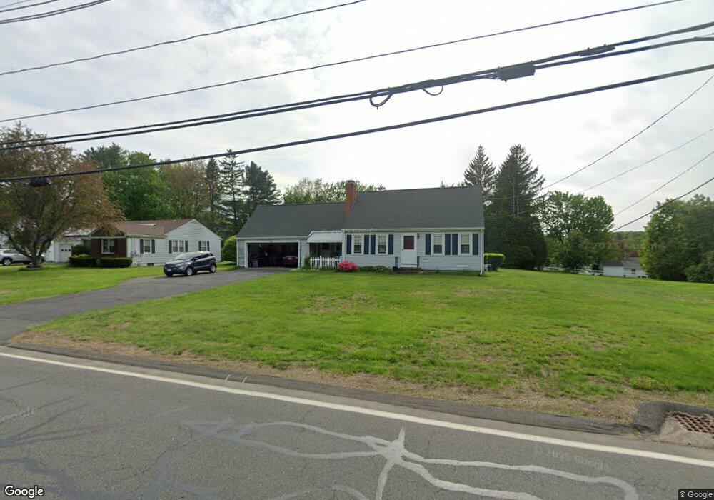
657 Rogers Ave West Springfield, MA 01089
Estimated Value: $430,886 - $476,000
4
Beds
2
Baths
1,800
Sq Ft
$248/Sq Ft
Est. Value
About This Home
This home is located at 657 Rogers Ave, West Springfield, MA 01089 and is currently estimated at $446,722, approximately $248 per square foot. 657 Rogers Ave is a home located in Hampden County with nearby schools including West Springfield High School and St Thomas The Apostle School.
Ownership History
Date
Name
Owned For
Owner Type
Purchase Details
Closed on
Mar 30, 1998
Sold by
Carl B Johnson Ret and Rice Jonathan P
Bought by
Matthews Charles T and Matthews Susan A
Current Estimated Value
Create a Home Valuation Report for This Property
The Home Valuation Report is an in-depth analysis detailing your home's value as well as a comparison with similar homes in the area
Home Values in the Area
Average Home Value in this Area
Purchase History
| Date | Buyer | Sale Price | Title Company |
|---|---|---|---|
| Matthews Charles T | $77,500 | -- | |
| Matthews Charles T | $77,500 | -- |
Source: Public Records
Mortgage History
| Date | Status | Borrower | Loan Amount |
|---|---|---|---|
| Open | Matthews Charles T | $127,000 | |
| Closed | Matthews Charles T | $55,000 | |
| Closed | Matthews Charles T | $50,000 |
Source: Public Records
Tax History
| Year | Tax Paid | Tax Assessment Tax Assessment Total Assessment is a certain percentage of the fair market value that is determined by local assessors to be the total taxable value of land and additions on the property. | Land | Improvement |
|---|---|---|---|---|
| 2025 | $5,332 | $358,600 | $124,500 | $234,100 |
| 2024 | $5,339 | $360,500 | $124,500 | $236,000 |
| 2023 | $4,915 | $316,300 | $124,500 | $191,800 |
| 2022 | $4,487 | $284,700 | $113,100 | $171,600 |
| 2021 | $4,129 | $244,300 | $92,400 | $151,900 |
| 2020 | $4,103 | $241,500 | $92,400 | $149,100 |
| 2019 | $4,096 | $241,500 | $92,400 | $149,100 |
| 2018 | $4,118 | $241,500 | $92,400 | $149,100 |
| 2017 | $4,118 | $241,500 | $92,400 | $149,100 |
| 2016 | $4,059 | $238,900 | $86,800 | $152,100 |
| 2015 | $3,981 | $234,300 | $85,200 | $149,100 |
| 2014 | $967 | $234,300 | $85,200 | $149,100 |
Source: Public Records
Map
Nearby Homes
- 34 Pebble Path Ln
- 34 High Meadow Dr
- 66 Penrose Dr
- 0 Ahiska Rd Unit 73477754
- 791 Morgan Rd
- 17 Vincent Dr
- 86 Albert St
- 88 Verdugo St
- 65 Verdugo St
- 240 Morton St
- 1996 Westfield St
- 117 Sibley Ave
- 132 Lincoln St
- 156 Canterbury Way
- 36 Shady Brook
- 32 Glenview Dr
- 81 Chestnut St
- 2 Windpath E
- 32 Maple St
- 242 Eastwood Dr
- 647 Rogers Ave
- 673 Rogers Ave
- 673 Rogers Ave Unit 1
- 81 Westwood Dr
- 635 Rogers Ave
- 65 Westwood Dr
- 91 Westwood Dr
- 658 Rogers Ave
- 668 Rogers Ave
- 646 Rogers Ave
- 625 Rogers Ave
- 55 Westwood Dr
- 691 Rogers Ave
- 638 Rogers Ave
- 684 Rogers Ave
- 111 Westwood Dr
- 45 Westwood Dr
- 626 Rogers Ave
- 615 Rogers Ave
- 701 Rogers Ave
Your Personal Tour Guide
Ask me questions while you tour the home.