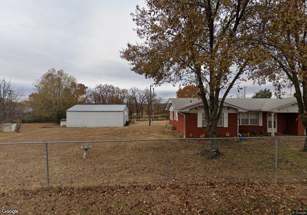
659 Mohawk Dr Eufaula, OK 74432
Estimated Value: $185,000 - $240,000
2
Beds
2
Baths
1,216
Sq Ft
$166/Sq Ft
Est. Value
About This Home
This home is located at 659 Mohawk Dr, Eufaula, OK 74432 and is currently estimated at $201,380, approximately $165 per square foot. 659 Mohawk Dr is a home located in McIntosh County with nearby schools including Eufaula Elementary School, Eufaula Middle School, and Eufaula High School.
Ownership History
Date
Name
Owned For
Owner Type
Purchase Details
Closed on
Feb 17, 2023
Sold by
Clark Regenia
Bought by
Clark Regenia and Minneck Barbara
Current Estimated Value
Purchase Details
Closed on
Nov 28, 2005
Sold by
Arbuckle Diana J and Arbuckle Dennis
Bought by
Clark Alton and Clark Regenia S
Purchase Details
Closed on
Nov 30, 2004
Sold by
Hughes
Bought by
Arbuckle
Purchase Details
Closed on
Aug 8, 1990
Create a Home Valuation Report for This Property
The Home Valuation Report is an in-depth analysis detailing your home's value as well as a comparison with similar homes in the area
Home Values in the Area
Average Home Value in this Area
Purchase History
| Date | Buyer | Sale Price | Title Company |
|---|---|---|---|
| Clark Regenia | -- | -- | |
| Clark Alton | $65,000 | None Available | |
| Arbuckle | $56,000 | -- | |
| -- | $27,000 | -- |
Source: Public Records
Tax History
| Year | Tax Paid | Tax Assessment Tax Assessment Total Assessment is a certain percentage of the fair market value that is determined by local assessors to be the total taxable value of land and additions on the property. | Land | Improvement |
|---|---|---|---|---|
| 2025 | $1,281 | $14,640 | $4,015 | $10,625 |
| 2024 | $1,269 | $14,526 | $4,015 | $10,511 |
| 2023 | $1,269 | $7,203 | $1,224 | $5,979 |
| 2022 | $432 | $7,203 | $1,224 | $5,979 |
| 2021 | $437 | $7,204 | $1,293 | $5,911 |
| 2020 | $437 | $7,204 | $1,293 | $5,911 |
| 2019 | $441 | $7,203 | $1,564 | $5,639 |
| 2018 | $433 | $7,203 | $770 | $6,433 |
| 2017 | $433 | $7,203 | $770 | $6,433 |
| 2016 | $435 | $7,203 | $770 | $6,433 |
| 2015 | $430 | $7,203 | $770 | $6,433 |
| 2014 | $427 | $7,203 | $770 | $6,433 |
Source: Public Records
Map
Nearby Homes
- 4 E 1200
- 6 E 1200
- 8 E 1200
- 0 Quapaw St Unit 2540983
- 229 Seminole Dr
- 230 Seminole Dr
- 0 Choctaw Dr Unit 2514518
- 0 Choctaw Dr Unit 2515676
- 0 Choctaw Dr Unit 2515656
- 589 Mohawk
- 0000 Choctaw Dr
- 721 Mohawk Dr
- 989 Sequoyah Dr
- 120290 S 4182 Rd
- 120347 S 4186 Rd
- 0 Comanche Dr Unit OKC1219168
- 7018 Lakeshore Dr Unit 18
- 701 Lakeshore Dr
- 411 Booker t Washington St
- 107 N J St
- 659 Mohawk Dr
- 645 Mohawk Dr
- 972 Creek Dr
- 709 Mohawk Dr
- 635 Mohawk Dr
- 0 Mohawk Dr
- 634 Mohawk Dr
- 154 Sequoyah Dr
- 992 Sequoyah Dr
- 634 Mohawk Dr
- 709 Shawnee Dr
- 0 Cherokee Dr Unit 1543780
- 0 Cherokee Dr Unit 2000352
- 0 Cherokee Dr Unit 2023251
- 0 Cherokee Dr Unit 2210176
- 0 Cherokee Dr Unit 2210174
- 19245 County Road 1550
- 708 Quapaw Dr
- 705 Creek Dr
- 0 Creek Dr
Your Personal Tour Guide
Ask me questions while you tour the home.