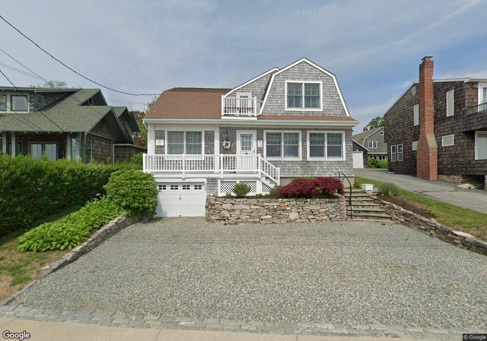
66 E Shore Ave Groton, CT 06340
Estimated Value: $1,104,000 - $1,685,000
4
Beds
3
Baths
2,584
Sq Ft
$544/Sq Ft
Est. Value
About This Home
This home is located at 66 E Shore Ave, Groton, CT 06340 and is currently estimated at $1,404,736, approximately $543 per square foot. 66 E Shore Ave is a home located in New London County with nearby schools including Groton Middle School and Robert E. Fitch High School.
Ownership History
Date
Name
Owned For
Owner Type
Purchase Details
Closed on
Sep 10, 1998
Sold by
Sagolla Donald T and Sagolla Michelle K
Bought by
Salerno Nicholas R and Salerno Nancy
Current Estimated Value
Home Financials for this Owner
Home Financials are based on the most recent Mortgage that was taken out on this home.
Original Mortgage
$150,000
Interest Rate
6.92%
Mortgage Type
Unknown
Purchase Details
Closed on
Jun 29, 1988
Sold by
Wiley Gratia
Bought by
Sagolla Donald
Home Financials for this Owner
Home Financials are based on the most recent Mortgage that was taken out on this home.
Original Mortgage
$250,000
Interest Rate
10.47%
Create a Home Valuation Report for This Property
The Home Valuation Report is an in-depth analysis detailing your home's value as well as a comparison with similar homes in the area
Purchase History
| Date | Buyer | Sale Price | Title Company |
|---|---|---|---|
| Salerno Nicholas R | $340,000 | -- | |
| Sagolla Donald | $418,000 | -- |
Source: Public Records
Mortgage History
| Date | Status | Borrower | Loan Amount |
|---|---|---|---|
| Closed | Sagolla Donald | $150,000 | |
| Previous Owner | Sagolla Donald | $237,000 | |
| Previous Owner | Sagolla Donald | $250,000 |
Source: Public Records
Tax History
| Year | Tax Paid | Tax Assessment Tax Assessment Total Assessment is a certain percentage of the fair market value that is determined by local assessors to be the total taxable value of land and additions on the property. | Land | Improvement |
|---|---|---|---|---|
| 2025 | $17,680 | $627,620 | $472,094 | $155,526 |
| 2024 | $16,594 | $627,620 | $472,094 | $155,526 |
| 2023 | $15,998 | $627,620 | $405,440 | $222,180 |
| 2022 | $15,697 | $627,620 | $405,440 | $222,180 |
| 2021 | $19,393 | $644,070 | $450,450 | $193,620 |
| 2020 | $19,108 | $644,070 | $450,450 | $193,620 |
| 2019 | $18,322 | $644,070 | $450,450 | $193,620 |
| 2018 | $17,957 | $644,070 | $450,450 | $193,620 |
| 2017 | $17,602 | $644,070 | $450,450 | $193,620 |
| 2016 | $18,030 | $729,260 | $488,250 | $241,010 |
| 2015 | $17,462 | $729,260 | $488,250 | $241,010 |
| 2014 | $16,901 | $729,260 | $488,250 | $241,010 |
Source: Public Records
Map
Nearby Homes
- 64 E Shore Ave
- 68 E Shore Ave
- 62 E Shore Ave
- 15 Middlefield St
- 60 E Shore Ave
- 17 Middlefield St
- 72 E Shore Ave
- 13 Middlefield St
- 19 Middlefield St
- 21 Middlefield St
- 58 E Shore Ave
- 11 Middlefield St
- 74 E Shore Ave
- 23 Middlefield St
- 76 E Shore Ave
- 56 E Shore Ave
- 18 Middlefield St
- 7 Middlefield St
- 16 Middlefield St
- 20 Middlefield St
Your Personal Tour Guide
Ask me questions while you tour the home.