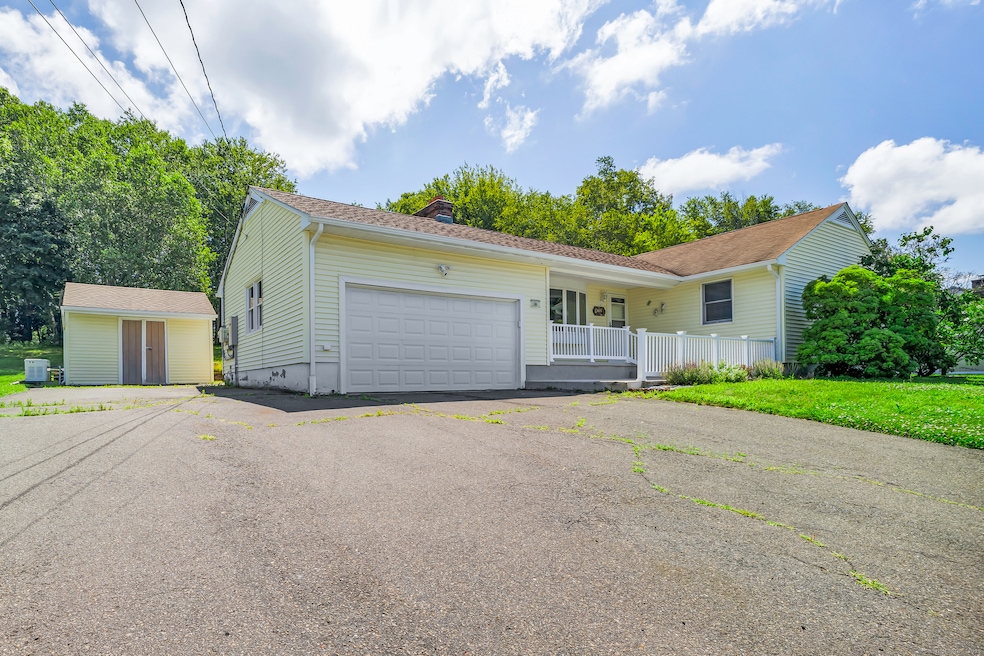
66 Mattatuck Rd Bristol, CT 06010
South Bristol NeighborhoodEstimated payment $2,538/month
Highlights
- 0.72 Acre Lot
- Attic
- Thermal Windows
- Ranch Style House
- 1 Fireplace
- Porch
About This Home
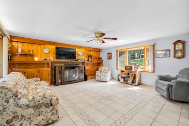
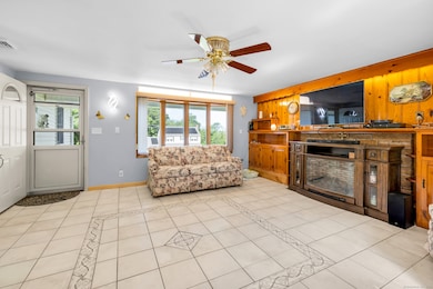
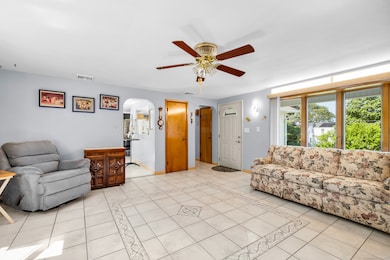
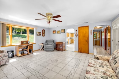
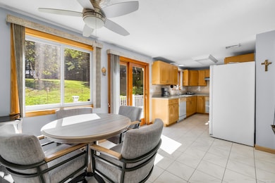
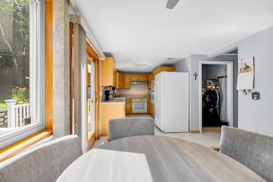
Spacious, sunlit, and set on a private stretch of Mattatuck Road, this charming Bristol ranch offers single-floor living with bonus finished space below. Inside, you'll find large rooms, tile flooring throughout the main living areas, and a kitchen with solid wood cabinets, ample counter space, and a dining nook that walks right out to the yard. The bright living room features built-ins, a cozy fireplace, and a picture window that draws in natural light and backyard views. The basement was fully remodeled and offers incredible flexibility. It includes a full bathroom, bedroom, and a generously sized living area-perfect for an in-law setup, extended guests, or that bonus hangout space you've been needing. Enjoy the peace and privacy of the expansive backyard, complete with a brick grill area, mature trees lining the property, and a stone retaining wall that adds charm to the patio space. Additional highlights include a full-house Generac generator and solar panels that are nearly paid off, adding long-term savings and convenience. All tucked away in a quiet setting, yet just minutes to local shopping, dining, and highway access.
Listing Agent
eXp Realty Brokerage Phone: (860) 966-1139 License #RES.0795727 Listed on: 07/17/2025

Home Details
Home Type
- Single Family
Est. Annual Taxes
- $5,160
Year Built
- Built in 1956
Lot Details
- 0.72 Acre Lot
- Garden
- Property is zoned R-25
Home Design
- Ranch Style House
- Concrete Foundation
- Asphalt Shingled Roof
- Concrete Siding
- Vinyl Siding
Interior Spaces
- Central Vacuum
- Ceiling Fan
- 1 Fireplace
- Thermal Windows
Kitchen
- Built-In Oven
- Microwave
- Dishwasher
- Smart Appliances
- Disposal
Bedrooms and Bathrooms
- 3 Bedrooms
- 2 Full Bathrooms
Laundry
- Laundry on main level
- Dryer
- Washer
Attic
- Storage In Attic
- Pull Down Stairs to Attic
Finished Basement
- Heated Basement
- Basement Fills Entire Space Under The House
- Interior Basement Entry
- Garage Access
Home Security
- Home Security System
- Storm Doors
Parking
- 2 Car Garage
- Automatic Garage Door Opener
- Driveway
Accessible Home Design
- Accessible Bathroom
- Exterior Wheelchair Lift
- Chairlift
- Raised Toilet
Eco-Friendly Details
- Solar Heating System
- Heating system powered by active solar
Outdoor Features
- Patio
- Shed
- Rain Gutters
- Porch
Schools
- South Side Elementary School
- Bristol Central High School
Utilities
- Heat Pump System
- Baseboard Heating
- Power Generator
- Private Company Owned Well
- Cable TV Available
Listing and Financial Details
- Assessor Parcel Number 466395
Map
Home Values in the Area
Average Home Value in this Area
Tax History
| Year | Tax Paid | Tax Assessment Tax Assessment Total Assessment is a certain percentage of the fair market value that is determined by local assessors to be the total taxable value of land and additions on the property. | Land | Improvement |
|---|---|---|---|---|
| 2025 | $5,160 | $152,880 | $47,880 | $105,000 |
| 2024 | $4,869 | $152,880 | $47,880 | $105,000 |
| 2023 | $4,640 | $152,880 | $47,880 | $105,000 |
| 2022 | $4,083 | $106,470 | $35,630 | $70,840 |
| 2021 | $4,083 | $106,470 | $35,630 | $70,840 |
| 2020 | $4,083 | $106,470 | $35,630 | $70,840 |
| 2019 | $4,051 | $106,470 | $35,630 | $70,840 |
| 2018 | $3,927 | $106,470 | $35,630 | $70,840 |
| 2017 | $4,040 | $112,140 | $50,890 | $61,250 |
| 2016 | $4,101 | $113,820 | $50,890 | $62,930 |
| 2015 | $3,939 | $113,820 | $50,890 | $62,930 |
| 2014 | $3,939 | $113,820 | $50,890 | $62,930 |
Property History
| Date | Event | Price | List to Sale | Price per Sq Ft |
|---|---|---|---|---|
| 10/29/2025 10/29/25 | Price Changed | $400,000 | -3.6% | $183 / Sq Ft |
| 09/17/2025 09/17/25 | Price Changed | $415,000 | -2.4% | $190 / Sq Ft |
| 07/17/2025 07/17/25 | For Sale | $425,000 | -- | $195 / Sq Ft |
Purchase History
| Date | Type | Sale Price | Title Company |
|---|---|---|---|
| Warranty Deed | $265,000 | -- | |
| Deed | -- | -- |
Mortgage History
| Date | Status | Loan Amount | Loan Type |
|---|---|---|---|
| Open | $209,605 | FHA | |
| Previous Owner | $125,000 | Stand Alone Refi Refinance Of Original Loan | |
| Previous Owner | $69,300 | No Value Available | |
| Previous Owner | $132,000 | No Value Available |
Source: SmartMLS
MLS Number: 24111481
APN: BRIS-000006-000000-000029
Disclaimer: Certain information contained herein is derived from information provided by parties other than Homes.com. All information provided is deemed reliable, but is not guaranteed to be accurate and should be independently verified.
![]() IDX information is provided exclusively for personal, non-commercial use, and may not be used for any purpose other than to identify prospective properties consumers may be interested in purchasing. Information is deemed reliable but not guaranteed.
IDX information is provided exclusively for personal, non-commercial use, and may not be used for any purpose other than to identify prospective properties consumers may be interested in purchasing. Information is deemed reliable but not guaranteed.
- 351 Witches Rock Rd
- 32 Cameron Dr
- 26 Kilmartin Ave
- 115 Old Wolcott Rd
- 121 Barclare Ln
- 489 Wolcott St Unit 46
- 489 Wolcott St Unit 47
- 489 Wolcott St Unit 74
- 489 Wolcott St Unit 25
- 489 Wolcott St Unit 85
- 155 Melinda Ln
- 140 Corbin Ridge
- 123 Corbin Ridge
- 156 Corbin Ridge
- 145 Corbin Ridge
- 101 Corbin Ridge
- 115 Kilmartin Ave
- 41 Long Swamp Rd
- 1253 Spindle Hill Rd
- 48 Cancellaro Dr
- 17 Brookview Cir Unit 17
- 42 Eastview Rd
- 111-159 Union St
- 30 Cottage St Unit 2
- 30 Cottage St Unit 3
- 42 South St Unit 1
- 62 Briarwood Rd Unit 3
- 43-2 George St Unit 2nd flr
- 25 George St
- 33 Emory Ct
- 19 Upson St
- 41 Pleasant St
- 1 Divinity St Unit 3F
- 137 School St Unit 135 school street
- 218 West St Unit D2
- 100 N Main St Unit 411
- 100 N Main St Unit 412
- 52 Jacobs St
- 38 Prospect St Unit 38
- 22 High St