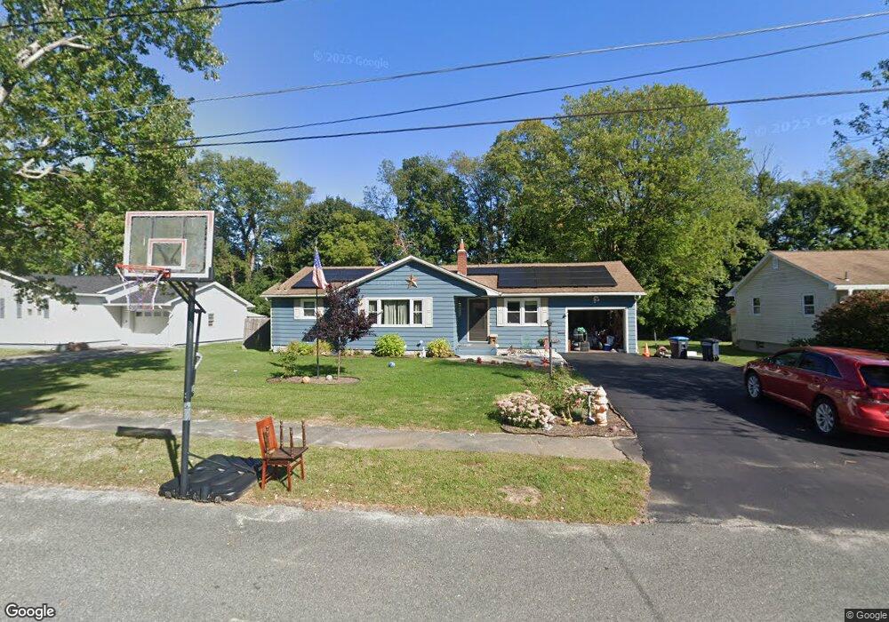
66 Nancy Ave Pittsfield, MA 01201
Estimated Value: $312,000 - $366,773
3
Beds
2
Baths
1,362
Sq Ft
$246/Sq Ft
Est. Value
About This Home
This home is located at 66 Nancy Ave, Pittsfield, MA 01201 and is currently estimated at $334,693, approximately $245 per square foot. 66 Nancy Ave is a home located in Berkshire County with nearby schools including Williams Elementary School, Theodore Herberg Middle School, and Pittsfield High School.
Ownership History
Date
Name
Owned For
Owner Type
Purchase Details
Closed on
Mar 25, 2013
Sold by
Thomas J Mathews Irt and Mathews
Bought by
Kubli Morgan L
Current Estimated Value
Purchase Details
Closed on
Jul 9, 2012
Sold by
Mathews Thomas J
Bought by
Thomas J Mathews 2011 and Mathews
Purchase Details
Closed on
Oct 10, 2008
Sold by
Schuler Anita L and Schuler Robert L
Bought by
Mathews Thomas J
Home Financials for this Owner
Home Financials are based on the most recent Mortgage that was taken out on this home.
Original Mortgage
$65,000
Interest Rate
6.43%
Mortgage Type
Purchase Money Mortgage
Create a Home Valuation Report for This Property
The Home Valuation Report is an in-depth analysis detailing your home's value as well as a comparison with similar homes in the area
Home Values in the Area
Average Home Value in this Area
Purchase History
| Date | Buyer | Sale Price | Title Company |
|---|---|---|---|
| Kubli Morgan L | -- | -- | |
| Kubli Morgan L | -- | -- | |
| Kubli Morgan L | -- | -- | |
| Thomas J Mathews 2011 | -- | -- | |
| Thomas J Mathews 2011 | -- | -- | |
| Thomas J Mathews 2011 | -- | -- | |
| Mathews Thomas J | $165,000 | -- | |
| Mathews Thomas J | $165,000 | -- | |
| Mathews Thomas J | $165,000 | -- |
Source: Public Records
Mortgage History
| Date | Status | Borrower | Loan Amount |
|---|---|---|---|
| Previous Owner | Mathews Thomas J | $65,000 |
Source: Public Records
Tax History Compared to Growth
Tax History
| Year | Tax Paid | Tax Assessment Tax Assessment Total Assessment is a certain percentage of the fair market value that is determined by local assessors to be the total taxable value of land and additions on the property. | Land | Improvement |
|---|---|---|---|---|
| 2025 | $5,698 | $317,600 | $81,000 | $236,600 |
| 2024 | $5,033 | $272,800 | $81,000 | $191,800 |
| 2023 | $4,732 | $258,300 | $81,000 | $177,300 |
| 2022 | $4,365 | $235,200 | $81,000 | $154,200 |
| 2021 | $4,139 | $215,000 | $81,000 | $134,000 |
| 2020 | $3,948 | $200,300 | $71,000 | $129,300 |
| 2019 | $3,630 | $186,900 | $71,000 | $115,900 |
| 2018 | $3,588 | $179,300 | $66,000 | $113,300 |
| 2017 | $3,243 | $165,200 | $56,000 | $109,200 |
| 2016 | $3,049 | $162,500 | $56,000 | $106,500 |
| 2015 | $2,935 | $162,500 | $56,000 | $106,500 |
Source: Public Records
Map
Nearby Homes
- 787 Williams St
- 76 Alfred Dr
- 932 Williams St
- 50 Bellmore Dr
- 165 Harryel St
- 171 Harryel St
- 59 Bellmore Dr
- 64 Elaine Dr
- 989 Williams St
- 26 Filomena Dr
- 204 Harryel St
- 59 Joan Dr
- 215 Pine Grove Dr
- 210 Pine Grove Dr
- 225 Karen Dr
- 157 Maple Grove Dr
- 4 Filomena Dr
- 64 & 68 Brookside Dr
- 25 E New Lenox Rd
- 44 Marcella Ave