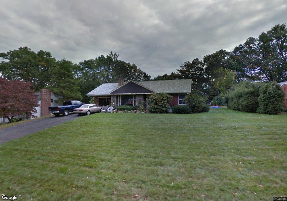
66 Pinehurst Rd Holyoke, MA 01040
Estimated Value: $319,000 - $372,000
2
Beds
1
Bath
1,448
Sq Ft
$236/Sq Ft
Est. Value
About This Home
This home is located at 66 Pinehurst Rd, Holyoke, MA 01040 and is currently estimated at $341,570, approximately $235 per square foot. 66 Pinehurst Rd is a home located in Hampden County with nearby schools including H.B. Lawrence Elementary School, Holyoke High School, and Holyoke Community Charter School.
Ownership History
Date
Name
Owned For
Owner Type
Purchase Details
Closed on
Feb 27, 1998
Sold by
Ford William G
Bought by
Smith Ronald A and Smith Maryann D
Current Estimated Value
Home Financials for this Owner
Home Financials are based on the most recent Mortgage that was taken out on this home.
Original Mortgage
$95,400
Interest Rate
6.85%
Mortgage Type
Purchase Money Mortgage
Create a Home Valuation Report for This Property
The Home Valuation Report is an in-depth analysis detailing your home's value as well as a comparison with similar homes in the area
Home Values in the Area
Average Home Value in this Area
Purchase History
| Date | Buyer | Sale Price | Title Company |
|---|---|---|---|
| Smith Ronald A | $106,000 | -- |
Source: Public Records
Mortgage History
| Date | Status | Borrower | Loan Amount |
|---|---|---|---|
| Open | Smith Ronald A | $79,000 | |
| Closed | Smith Ronald A | $95,400 |
Source: Public Records
Tax History Compared to Growth
Tax History
| Year | Tax Paid | Tax Assessment Tax Assessment Total Assessment is a certain percentage of the fair market value that is determined by local assessors to be the total taxable value of land and additions on the property. | Land | Improvement |
|---|---|---|---|---|
| 2025 | $4,796 | $274,700 | $51,900 | $222,800 |
| 2024 | $4,468 | $235,800 | $49,200 | $186,600 |
| 2023 | $4,268 | $227,500 | $49,200 | $178,300 |
| 2022 | $4,097 | $212,700 | $49,200 | $163,500 |
| 2021 | $4,079 | $202,300 | $47,700 | $154,600 |
| 2020 | $3,694 | $193,600 | $47,700 | $145,900 |
| 2019 | $3,555 | $184,300 | $47,700 | $136,600 |
| 2018 | $3,888 | $177,200 | $47,700 | $129,500 |
| 2017 | $3,749 | $177,200 | $47,700 | $129,500 |
| 2016 | $3,348 | $175,100 | $49,200 | $125,900 |
| 2015 | $3,334 | $175,100 | $49,200 | $125,900 |
Source: Public Records
Map
Nearby Homes
- 141 Saint Jerome Ave
- 140 Sycamore St
- 1793 Northampton St
- 268-270 Sargeant St
- 1705-1707 Northampton St
- 1684 Northampton St
- 201 Locust St
- 443-445 Beech St
- 58-60 Brookline Ave
- 301-303 Linden St
- 69 Gates St
- 329 Beech St
- 21 Francis Ave
- 1421 Dwight St
- 414 South St
- 225 Beech St Unit 227
- 70-72 Westfield Rd
- 0 High St
- 2027-2029 Northampton St
- 1114 Hampden St