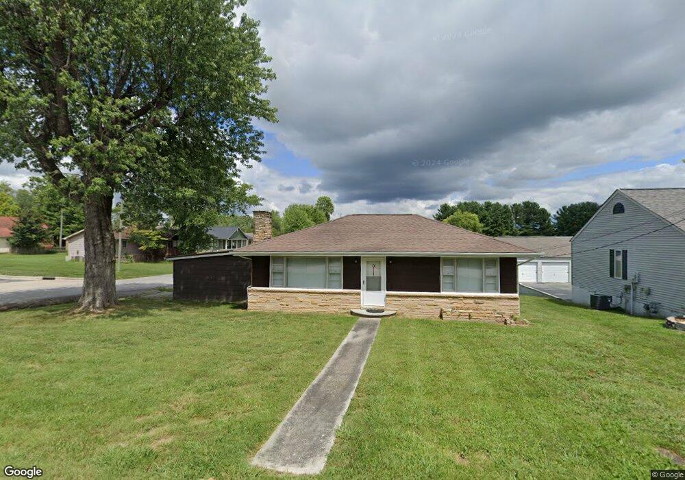
66 Underwood St Crossville, TN 38555
Estimated Value: $103,855 - $197,000
--
Bed
1
Bath
925
Sq Ft
$146/Sq Ft
Est. Value
About This Home
This home is located at 66 Underwood St, Crossville, TN 38555 and is currently estimated at $135,464, approximately $146 per square foot. 66 Underwood St is a home located in Cumberland County with nearby schools including Glenn Martin Elementary School, Cumberland County High School, and Christian Academy of the Cumberlands.
Ownership History
Date
Name
Owned For
Owner Type
Purchase Details
Closed on
Jul 18, 2002
Sold by
Burnett Kenneth B
Bought by
Wyatt Ronnie D
Current Estimated Value
Purchase Details
Closed on
Jun 29, 1992
Bought by
Burnett Kenneth B
Purchase Details
Closed on
Dec 9, 1987
Bought by
Neal Richard M and Neal Tona A
Create a Home Valuation Report for This Property
The Home Valuation Report is an in-depth analysis detailing your home's value as well as a comparison with similar homes in the area
Home Values in the Area
Average Home Value in this Area
Purchase History
| Date | Buyer | Sale Price | Title Company |
|---|---|---|---|
| Wyatt Ronnie D | $45,750 | -- | |
| Burnett Kenneth B | $30,500 | -- | |
| Neal Richard M | $29,500 | -- |
Source: Public Records
Tax History Compared to Growth
Tax History
| Year | Tax Paid | Tax Assessment Tax Assessment Total Assessment is a certain percentage of the fair market value that is determined by local assessors to be the total taxable value of land and additions on the property. | Land | Improvement |
|---|---|---|---|---|
| 2025 | -- | $13,625 | $2,500 | $11,125 |
| 2024 | $155 | $13,625 | $2,500 | $11,125 |
| 2023 | $155 | $13,625 | $0 | $0 |
| 2022 | $238 | $13,625 | $2,500 | $11,125 |
| 2021 | $241 | $10,425 | $2,500 | $7,925 |
| 2020 | $163 | $10,425 | $2,500 | $7,925 |
| 2019 | $225 | $10,425 | $2,500 | $7,925 |
| 2018 | $225 | $10,425 | $2,500 | $7,925 |
| 2017 | $225 | $10,425 | $2,500 | $7,925 |
| 2016 | $233 | $10,800 | $2,500 | $8,300 |
| 2015 | $230 | $10,800 | $2,500 | $8,300 |
| 2014 | $219 | $10,808 | $0 | $0 |
Source: Public Records
Map
Nearby Homes
- 0
- 0 Sparta Highway 31 64+ - Acres
- 236 Miller Ave
- 1215 West Ave
- 0 Old Jamestown Hwy Unit RTC2781114
- 80 Mclarty Ln
- 796 West Ave
- 168 Sky View Meadow Dr
- 157 Sky View Meadow Dr
- 00 Highway 70 E
- 0
- 60 Sky View Meadow Dr
- HWY 127 Lot # 6 Hwy 127 N
- 0.08 ac Bilbrey St
- 0 Tenth Knight Unit 1294422
- 0 Tenth Knight Unit 235355
- 181 Braun St
- 108 Larissa St
- 40 Jamestown Ct
- Tract 10 Off Glenobey Rd