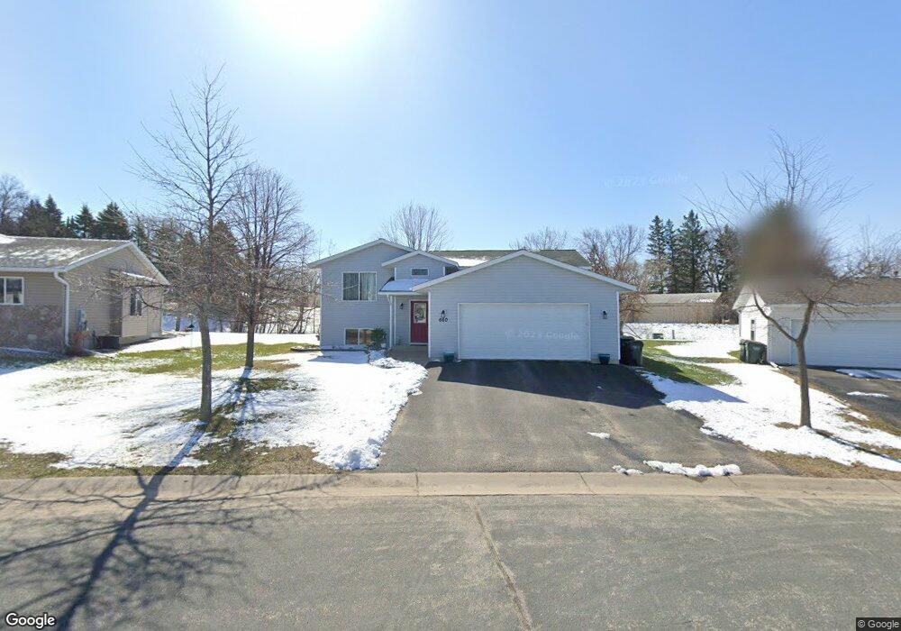
660 660 Texas Ave NW Hutchinson, MN 55350
Estimated Value: $331,335 - $353,000
5
Beds
2
Baths
1,521
Sq Ft
$227/Sq Ft
Est. Value
About This Home
This home is located at 660 660 Texas Ave NW, Hutchinson, MN 55350 and is currently estimated at $345,334, approximately $227 per square foot. 660 660 Texas Ave NW is a home located in McLeod County with nearby schools including Hutchinson West Elementary School, Hutchinson Park Elementary School, and Hutchinson Middle School.
Ownership History
Date
Name
Owned For
Owner Type
Purchase Details
Closed on
Oct 16, 2020
Sold by
Stock Wynn S and Stock Amy
Bought by
Stowell Jered P and Stowell Emily J
Current Estimated Value
Home Financials for this Owner
Home Financials are based on the most recent Mortgage that was taken out on this home.
Original Mortgage
$244,625
Outstanding Balance
$217,581
Interest Rate
2.9%
Mortgage Type
New Conventional
Estimated Equity
$127,753
Create a Home Valuation Report for This Property
The Home Valuation Report is an in-depth analysis detailing your home's value as well as a comparison with similar homes in the area
Home Values in the Area
Average Home Value in this Area
Purchase History
| Date | Buyer | Sale Price | Title Company |
|---|---|---|---|
| Stowell Jered P | $257,500 | Title Mark |
Source: Public Records
Mortgage History
| Date | Status | Borrower | Loan Amount |
|---|---|---|---|
| Open | Stowell Jered P | $244,625 |
Source: Public Records
Tax History Compared to Growth
Tax History
| Year | Tax Paid | Tax Assessment Tax Assessment Total Assessment is a certain percentage of the fair market value that is determined by local assessors to be the total taxable value of land and additions on the property. | Land | Improvement |
|---|---|---|---|---|
| 2024 | $4,332 | $315,800 | $68,600 | $247,200 |
| 2023 | $4,278 | $305,700 | $68,600 | $237,100 |
| 2022 | $3,858 | $288,800 | $65,300 | $223,500 |
| 2021 | $3,608 | $242,700 | $57,000 | $185,700 |
| 2020 | $3,554 | $218,500 | $51,900 | $166,600 |
| 2019 | $3,220 | $210,200 | $43,800 | $166,400 |
| 2018 | $3,010 | $0 | $0 | $0 |
| 2017 | $2,816 | $0 | $0 | $0 |
| 2016 | $2,666 | $0 | $0 | $0 |
| 2015 | $2,404 | $0 | $0 | $0 |
| 2014 | -- | $0 | $0 | $0 |
Source: Public Records
Map
Nearby Homes
- 525 Golf Course Rd NW
- 530 Lincoln Ave SW
- 126 Lynn Rd SW
- 490 California St NW
- 230 Lynn Rd SW
- 132 College Ave NE
- 545 4th Ave SW
- XXX Golf Course Rd NW
- 740 Ash St NE
- 310 & 312 4th Ave SW
- 966 Osgood Ave SW
- 725 Maple St NE
- 642 Juul Rd SW
- 1534 9th Ave SW
- 524 Bluff St NE
- 236 10th Ave NE
- 235 10th Ave NE
- 245 10th Ave NE
- 205 10th Ave NE
- 255 10th Ave NE
- 660 Texas Ave NW
- 670 Texas Ave NW
- 650 650 Texas-Avenue-nw
- 545 Highway 7 W
- 680 Texas Ave NW
- 680 680 Texas Ave NW
- 640 640 Texas-Avenue-nw
- 640 640 Texas Ave NW
- 640 Texas Ave NW
- 462 Kouwe St NW
- 462 462 Kouwe-Street-nw
- 645 Texas Ave NW
- 690 Texas Ave NW
- 630 Texas Ave NW
- 452 Kouwe St NW
- 472 Kouwe St NW
- 635 Texas Ave NW
- 635 635 Texas Ave NW
- 462 462 Kouwe St NW
- 620 Texas Ave NW