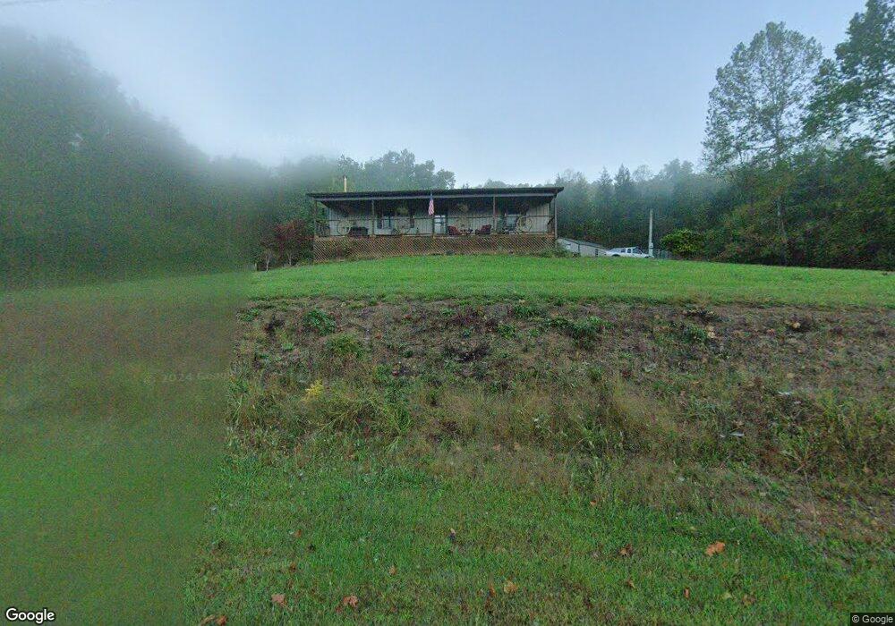
660 State Route 348 West Union, OH 45693
Estimated Value: $209,000 - $335,000
3
Beds
1
Bath
1,680
Sq Ft
$155/Sq Ft
Est. Value
About This Home
This home is located at 660 State Route 348, West Union, OH 45693 and is currently estimated at $260,139, approximately $154 per square foot. 660 State Route 348 is a home located in Adams County with nearby schools including West Union Elementary School and West Union High School.
Ownership History
Date
Name
Owned For
Owner Type
Purchase Details
Closed on
Oct 15, 2002
Sold by
Deitz Sophia S
Bought by
Franklyn David D
Current Estimated Value
Purchase Details
Closed on
Dec 20, 1999
Bought by
Deitz Sophia S
Purchase Details
Closed on
Sep 29, 1999
Sold by
Clark Linda
Bought by
D & J Partnership
Purchase Details
Closed on
Dec 14, 1998
Bought by
Clark Linda
Purchase Details
Closed on
Oct 7, 1998
Sold by
Graley Joseph R
Bought by
D & J Partnership
Purchase Details
Closed on
Jul 15, 1997
Sold by
Graley Joseph R
Bought by
Graley Joseph R
Purchase Details
Closed on
May 12, 1997
Bought by
Graley Joseph R
Purchase Details
Closed on
Aug 2, 1996
Bought by
D & J Partnership
Create a Home Valuation Report for This Property
The Home Valuation Report is an in-depth analysis detailing your home's value as well as a comparison with similar homes in the area
Home Values in the Area
Average Home Value in this Area
Purchase History
| Date | Buyer | Sale Price | Title Company |
|---|---|---|---|
| Franklyn David D | $35,000 | -- | |
| Deitz Sophia S | $32,500 | -- | |
| D & J Partnership | -- | -- | |
| Clark Linda | $29,500 | -- | |
| D & J Partnership | -- | -- | |
| Graley Joseph R | $39,900 | -- | |
| Graley Joseph R | $39,900 | -- | |
| D & J Partnership | -- | -- |
Source: Public Records
Tax History Compared to Growth
Tax History
| Year | Tax Paid | Tax Assessment Tax Assessment Total Assessment is a certain percentage of the fair market value that is determined by local assessors to be the total taxable value of land and additions on the property. | Land | Improvement |
|---|---|---|---|---|
| 2024 | $697 | $57,370 | $21,420 | $35,950 |
| 2023 | $1,674 | $57,370 | $21,420 | $35,950 |
| 2022 | $1,946 | $44,590 | $15,540 | $29,050 |
| 2021 | $1,639 | $44,590 | $15,540 | $29,050 |
| 2020 | $1,676 | $44,590 | $15,540 | $29,050 |
| 2019 | $1,676 | $44,590 | $15,540 | $29,050 |
| 2018 | $1,504 | $40,810 | $15,540 | $25,270 |
| 2017 | $1,480 | $40,810 | $15,540 | $25,270 |
| 2016 | $1,477 | $40,810 | $15,540 | $25,270 |
| 2015 | $442 | $12,640 | $11,620 | $1,020 |
| 2014 | $443 | $12,640 | $11,620 | $1,020 |
Source: Public Records
Map
Nearby Homes
- 598 Ohio 348
- 1011 Hafer Rd
- 1064 Hafer Rd
- 1186 Tulip Rd
- 1805 Waggoner Riffle Rd
- 467 Waggoner Riffle Rd
- 1460 Hamilton Rd
- 189 Hamilton Rd
- 4702 Brush Creek Rd
- 4702 Ohio Brush Creek Rd
- 410 Owens Rd
- 108 Chirsdon Ln
- 858 Randalls Run Rd
- 1478 Robinson Hollow Rd
- 2603 Cassel Run Rd
- 13465 State Route 41
- 405 Lookout View
- 292 Larry Baynum Rd
- 216 Kurt St
- 260 Randy St
- 598 State Route 348
- 585 State Route 348
- 727 State Route 348
- 727 State Route 348
- 545 State Route 348
- 566 State Route 348
- 750 State Route 348
- 999 State Route 348
- 468 State Route 348
- 811 State Route 348
- 841 State Route 348
- 890 State Route 348
- 1012 St Rt 348
- 1179 State Route 348
- 1200 Ralston Rd
- 380 Weaver Rd
- 80 Weaver Rd
- 1261 State Route 348
- 255 Weaver Rd
- 449 Weaver Rd