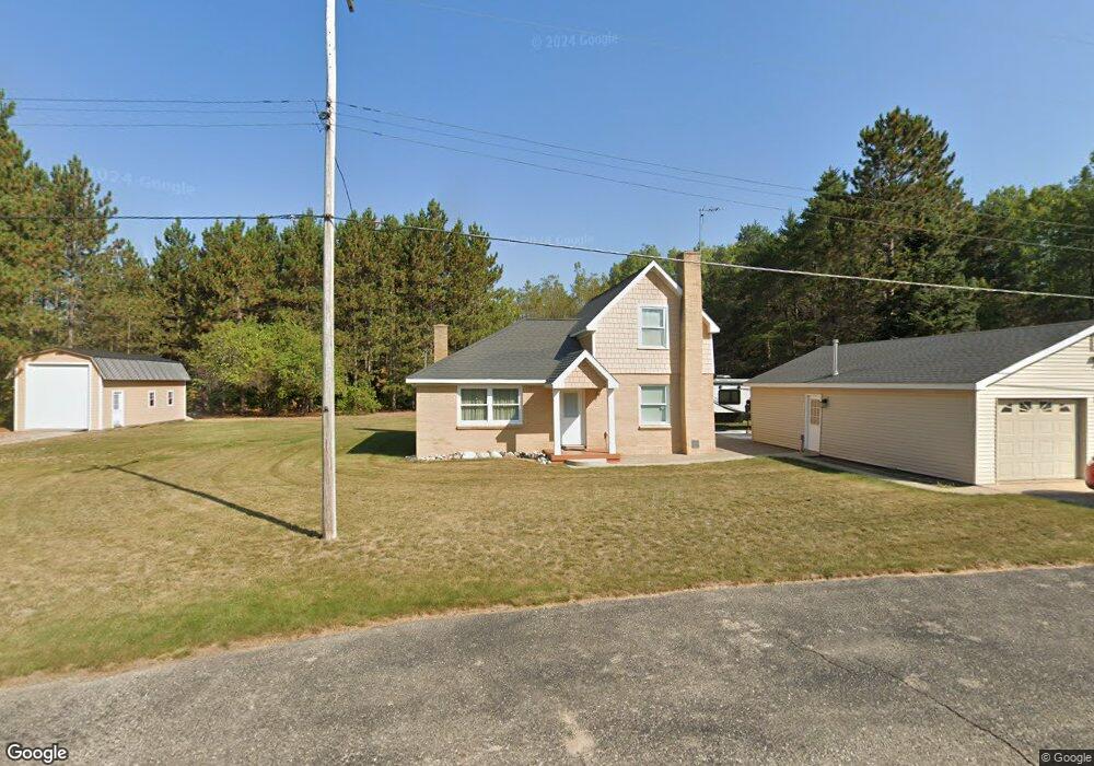
6605 E Bogardus St Pellston, MI 49769
Estimated Value: $177,075 - $263,000
Studio
--
Bath
--
Sq Ft
33,803
Sq Ft Lot
About This Home
This home is located at 6605 E Bogardus St, Pellston, MI 49769 and is currently estimated at $205,519. 6605 E Bogardus St is a home located in Emmet County with nearby schools including Pellston Elementary School and Pellston Middle/High School.
Ownership History
Date
Name
Owned For
Owner Type
Purchase Details
Closed on
Feb 19, 2019
Sold by
Schmidt Andy J
Bought by
Schmidt Andy J and Schmidt Bonnie J
Current Estimated Value
Purchase Details
Closed on
Apr 27, 2012
Sold by
St Francis X Fcu
Bought by
Davis Timothy M and Davis Kendra C
Home Financials for this Owner
Home Financials are based on the most recent Mortgage that was taken out on this home.
Original Mortgage
$18,000
Interest Rate
3.99%
Purchase Details
Closed on
Feb 10, 2011
Sold by
Watts Tl
Bought by
St Francis X Fcu
Purchase Details
Closed on
Nov 1, 1981
Bought by
Usa Fha
Purchase Details
Closed on
Mar 1, 1980
Bought by
Severance
Create a Home Valuation Report for This Property
The Home Valuation Report is an in-depth analysis detailing your home's value as well as a comparison with similar homes in the area
Purchase History
| Date | Buyer | Sale Price | Title Company |
|---|---|---|---|
| Schmidt Andy J | -- | -- | |
| Davis Timothy M | $20,000 | -- | |
| St Francis X Fcu | $57,893 | -- | |
| Usa Fha | -- | -- | |
| Severance | $31,500 | -- |
Source: Public Records
Mortgage History
| Date | Status | Borrower | Loan Amount |
|---|---|---|---|
| Previous Owner | Davis Timothy M | $18,000 |
Source: Public Records
Tax History
| Year | Tax Paid | Tax Assessment Tax Assessment Total Assessment is a certain percentage of the fair market value that is determined by local assessors to be the total taxable value of land and additions on the property. | Land | Improvement |
|---|---|---|---|---|
| 2025 | $1,354 | $75,500 | $75,500 | $0 |
| 2024 | $9 | $64,100 | $64,100 | $0 |
| 2023 | $1,263 | $59,400 | $59,400 | $0 |
| 2022 | $1,263 | $52,500 | $52,500 | $0 |
| 2021 | $1,310 | $49,900 | $49,900 | $0 |
| 2020 | $1,316 | $47,900 | $47,900 | $0 |
| 2019 | -- | $36,800 | $36,800 | $0 |
| 2018 | -- | $36,400 | $36,400 | $0 |
| 2017 | -- | $36,000 | $36,000 | $0 |
| 2016 | -- | $34,500 | $34,500 | $0 |
| 2015 | -- | $34,500 | $0 | $0 |
| 2014 | -- | $30,300 | $0 | $0 |
Source: Public Records
Map
Nearby Homes
- 6457 State St
- 6421 Airport Crossing Rd Unit 1
- 8959 Robinson Rd
- TBD Teal Rd
- 8016 Silver Strand Rd
- 11115 Douglas Lake Rd
- 4333 U S 31
- 10999 Koepke Rd
- 6105 U S 31
- 10222 W Munro Lake Dr
- 5100 N Bay Way
- 1830 Indian Point Rd
- 6167 Lambert Dr
- 6737 Honeysette Rd
- 1442 Indian Point Rd
- 7469 Sommers Rd
- 393 Beaux Rivages Dr
- 5441 Valley Rd
- 7084 Center St
- 7181 Maple St
- 337 Zipf St
- 351 Maple St
- 6614 E Bogardus St
- 315 Zipf St
- 321 Maple St
- 300 Maple St
- 307 Maple St
- 6661 E Bogardus St
- 6528 E Bogardus St
- 6585 E State St
- 312 Zipf St
- 303 Maple St
- 6504 E Bogardus St
- 6525 E State St
- 6496 E Bogardus St
- 374 Zipf St
- 6515 E State St
- 6503 E State St
- 6740 E Bogardus St
- 6607 State St
Your Personal Tour Guide
Ask me questions while you tour the home.