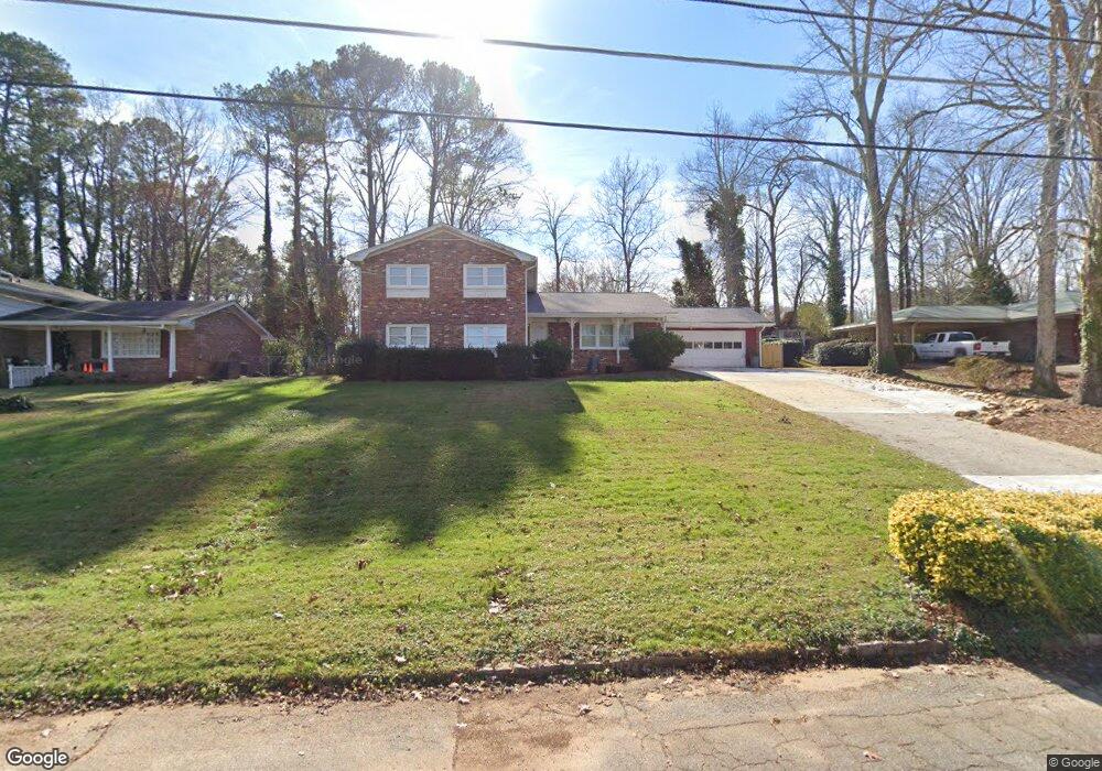
661 Tahoe Cir Unit 3 Stone Mountain, GA 30083
Estimated Value: $297,736 - $348,000
4
Beds
3
Baths
2,484
Sq Ft
$130/Sq Ft
Est. Value
About This Home
This home is located at 661 Tahoe Cir Unit 3, Stone Mountain, GA 30083 and is currently estimated at $321,934, approximately $129 per square foot. 661 Tahoe Cir Unit 3 is a home located in DeKalb County with nearby schools including Dunaire Elementary School, Freedom Middle School, and Clarkston High School.
Ownership History
Date
Name
Owned For
Owner Type
Purchase Details
Closed on
Apr 29, 2002
Sold by
Tritt William A and Tritt Martha F
Bought by
Defnall Daniel W
Current Estimated Value
Home Financials for this Owner
Home Financials are based on the most recent Mortgage that was taken out on this home.
Original Mortgage
$114,000
Outstanding Balance
$48,302
Interest Rate
7.12%
Mortgage Type
New Conventional
Estimated Equity
$273,632
Purchase Details
Closed on
Aug 10, 2001
Sold by
Delgado Humberto and Delgado Myriam
Bought by
Tritt William A and Tritt Martha F
Create a Home Valuation Report for This Property
The Home Valuation Report is an in-depth analysis detailing your home's value as well as a comparison with similar homes in the area
Home Values in the Area
Average Home Value in this Area
Purchase History
| Date | Buyer | Sale Price | Title Company |
|---|---|---|---|
| Defnall Daniel W | $152,000 | -- | |
| Tritt William A | $135,000 | -- |
Source: Public Records
Mortgage History
| Date | Status | Borrower | Loan Amount |
|---|---|---|---|
| Open | Defnall Daniel W | $114,000 |
Source: Public Records
Tax History Compared to Growth
Tax History
| Year | Tax Paid | Tax Assessment Tax Assessment Total Assessment is a certain percentage of the fair market value that is determined by local assessors to be the total taxable value of land and additions on the property. | Land | Improvement |
|---|---|---|---|---|
| 2025 | $3,747 | $114,120 | $18,160 | $95,960 |
| 2024 | $4,034 | $117,560 | $18,160 | $99,400 |
| 2023 | $4,034 | $105,400 | $15,000 | $90,400 |
| 2022 | $3,353 | $98,680 | $15,000 | $83,680 |
| 2021 | $2,387 | $70,600 | $10,000 | $60,600 |
| 2020 | $2,060 | $60,960 | $5,640 | $55,320 |
| 2019 | $2,202 | $65,800 | $5,640 | $60,160 |
| 2018 | $1,417 | $56,000 | $5,640 | $50,360 |
| 2017 | $1,898 | $55,000 | $5,640 | $49,360 |
| 2016 | $1,576 | $47,000 | $5,640 | $41,360 |
| 2014 | $1,274 | $34,360 | $5,640 | $28,720 |
Source: Public Records
Map
Nearby Homes
- 4128 Indian Manor Dr
- 3943 Dunaire Dr
- 3959 Wood Path Dr
- 3907 Dunaire Dr
- 539 Rue Montaigne
- 3901 W Wood Path
- 450 S Susan Creek Dr
- 4166 Rue Saint Michel
- 3901 Wood Path Dr
- 494 Rue Montaigne
- 4147 Scofield Place
- 3884 Wood Path Dr
- 3892 Springleaf Point
- 798 Durham Trail
- 719 Durham Crossing
- 4238 Rue Saint Michel
- 3838 Danbury Ln
- 653 Tahoe Cir Unit 3
- 669 Tahoe Cir Unit 3
- 4060 Indian Manor Dr
- 677 Tahoe Cir
- 645 Tahoe Cir Unit 3
- 4068 Indian Manor Dr
- 4052 Indian Manor Dr
- 0 Tahoe Cir Unit 7432898
- 0 Tahoe Cir Unit 8006221
- 0 Tahoe Cir Unit 7624582
- 0 Tahoe Cir Unit 8218428
- 0 Tahoe Cir Unit 8217237
- 0 Tahoe Cir
- 664 Tahoe Cir
- 4076 Indian Manor Dr
- 674 Tahoe Cir
- 4044 Indian Manor Dr
- 656 Tahoe Cir
- 648 Tahoe Cir Unit 3
- 685 Tahoe Cir