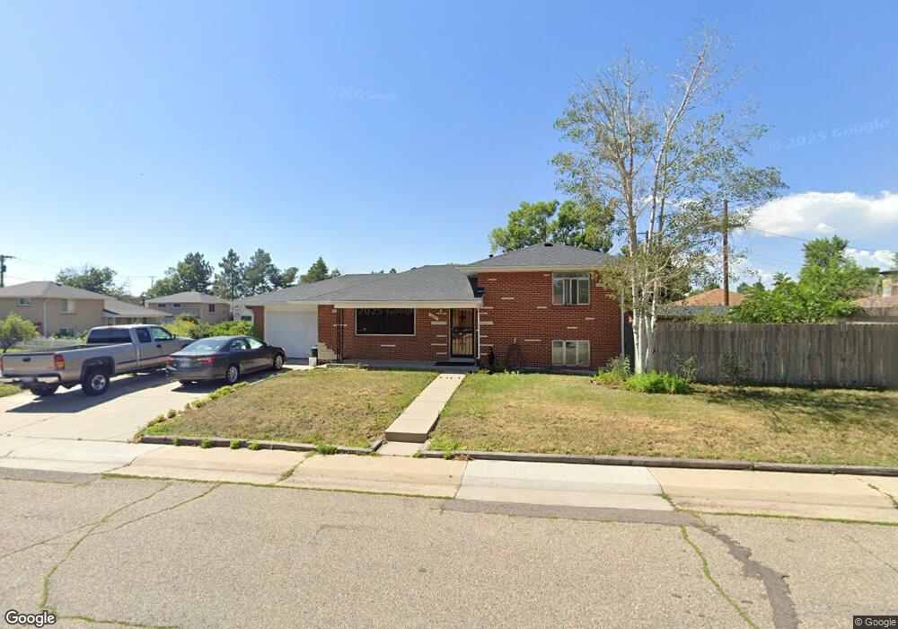
6610 W 54th Ave Arvada, CO 80002
Estimated Value: $464,583 - $568,000
3
Beds
3
Baths
980
Sq Ft
$540/Sq Ft
Est. Value
About This Home
This home is located at 6610 W 54th Ave, Arvada, CO 80002 and is currently estimated at $529,146, approximately $539 per square foot. 6610 W 54th Ave is a home located in Jefferson County with nearby schools including Secrest Elementary School, North Arvada Middle School, and Arvada High School.
Ownership History
Date
Name
Owned For
Owner Type
Purchase Details
Closed on
Sep 18, 2003
Sold by
Penry Daniel and Penry Linda
Bought by
Smart Stephen D and Smart Cheryl E
Current Estimated Value
Home Financials for this Owner
Home Financials are based on the most recent Mortgage that was taken out on this home.
Original Mortgage
$155,000
Outstanding Balance
$71,905
Interest Rate
6.24%
Mortgage Type
Purchase Money Mortgage
Estimated Equity
$457,241
Create a Home Valuation Report for This Property
The Home Valuation Report is an in-depth analysis detailing your home's value as well as a comparison with similar homes in the area
Home Values in the Area
Average Home Value in this Area
Purchase History
| Date | Buyer | Sale Price | Title Company |
|---|---|---|---|
| Smart Stephen D | $194,000 | -- | |
| Penry Daniel | -- | -- |
Source: Public Records
Mortgage History
| Date | Status | Borrower | Loan Amount |
|---|---|---|---|
| Open | Smart Stephen D | $155,000 |
Source: Public Records
Tax History Compared to Growth
Tax History
| Year | Tax Paid | Tax Assessment Tax Assessment Total Assessment is a certain percentage of the fair market value that is determined by local assessors to be the total taxable value of land and additions on the property. | Land | Improvement |
|---|---|---|---|---|
| 2024 | $2,232 | $29,101 | $13,002 | $16,099 |
| 2023 | $2,232 | $29,101 | $13,002 | $16,099 |
| 2022 | $1,893 | $25,830 | $9,753 | $16,077 |
| 2021 | $1,921 | $26,573 | $10,034 | $16,539 |
| 2020 | $1,606 | $23,409 | $8,025 | $15,384 |
| 2019 | $2,282 | $23,409 | $8,025 | $15,384 |
| 2018 | $2,042 | $20,355 | $5,441 | $14,914 |
| 2017 | $1,872 | $20,355 | $5,441 | $14,914 |
| 2016 | $1,622 | $16,595 | $5,276 | $11,319 |
| 2015 | $1,413 | $16,595 | $5,276 | $11,319 |
| 2014 | $1,413 | $13,580 | $4,872 | $8,708 |
Source: Public Records
Map
Nearby Homes
- 6247 W 53rd Ave
- 6890 W 55th Place
- 6801 W 52nd Ave
- 5465 Reed Ct
- 6910 Reno Dr
- 7011 Grandview Ave
- 5815 Pierce St Unit A-H
- 6105 W 49th Place
- 6480 W 60th Ave
- 7221 W 48th Ave
- 4835 Harlan St Unit 14-17
- 5320 Allison St Unit 106
- 5250 W 53rd Ave Unit 125
- 5250 W 53rd Ave Unit 116
- 5465 Zephyr St Unit 201
- 4730 Otis St
- 4730 Pierce St
- 7931 W 55th Ave Unit 308
- 7303 W 59th Ave
- 6920 W 47th Place
- 5385 Newland St
- 6660 W 54th Ave
- 5380 Nolan St
- 5375 Newland St
- 6621 W 54th Ave
- 6550 W 54th Ave
- 6615 W 54th Ave
- 5370 Nolan St
- 5380 Newland St
- 6627 W 54th Ave
- 6609 W 54th Ave
- 5370 Newland St
- 5365 Newland St
- 5410 Nolan St
- 5360 Nolan St
- 5415 Newland St
- 5360 Newland St
- 6630 W 54th Place
- 6620 W 54th Place
- 6640 W 54th Place