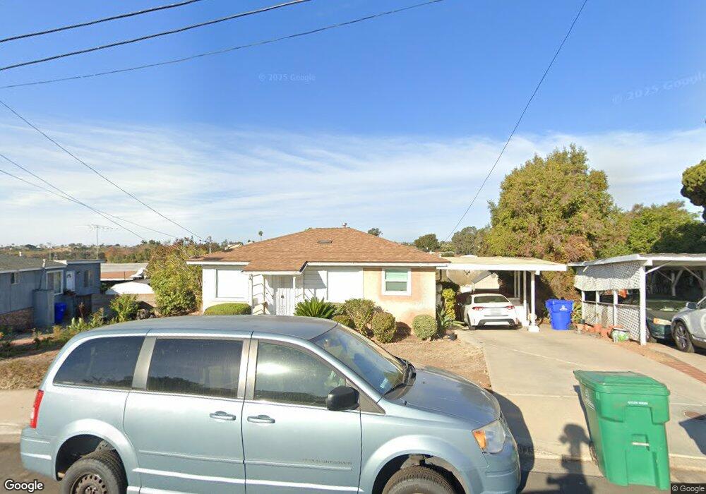
6611 Manning St San Diego, CA 92111
Linda Vista NeighborhoodEstimated Value: $845,000 - $987,000
3
Beds
2
Baths
1,126
Sq Ft
$817/Sq Ft
Est. Value
About This Home
This home is located at 6611 Manning St, San Diego, CA 92111 and is currently estimated at $919,882, approximately $816 per square foot. 6611 Manning St is a home located in San Diego County with nearby schools including Linda Vista Elementary School, Montgomery Middle School, and San Diego Cooperative Charter School.
Ownership History
Date
Name
Owned For
Owner Type
Purchase Details
Closed on
Nov 19, 2019
Sold by
Taylor Albert M and The Taylor Family Trust
Bought by
Taylor Areanna V
Current Estimated Value
Purchase Details
Closed on
Feb 3, 2017
Sold by
Taylor Loretta G
Bought by
Taylor Loretta G
Purchase Details
Closed on
Sep 21, 1999
Sold by
Taylor Albert W and Taylor Loretta G
Bought by
Taylor Albert W and Taylor Lorretta G
Create a Home Valuation Report for This Property
The Home Valuation Report is an in-depth analysis detailing your home's value as well as a comparison with similar homes in the area
Home Values in the Area
Average Home Value in this Area
Purchase History
| Date | Buyer | Sale Price | Title Company |
|---|---|---|---|
| Taylor Areanna V | -- | None Available | |
| Taylor Loretta G | -- | None Available | |
| Taylor Albert W | -- | -- |
Source: Public Records
Tax History Compared to Growth
Tax History
| Year | Tax Paid | Tax Assessment Tax Assessment Total Assessment is a certain percentage of the fair market value that is determined by local assessors to be the total taxable value of land and additions on the property. | Land | Improvement |
|---|---|---|---|---|
| 2025 | $6,569 | $546,819 | $464,798 | $82,021 |
| 2024 | $6,569 | $536,098 | $455,685 | $80,413 |
| 2023 | $6,423 | $525,587 | $446,750 | $78,837 |
| 2022 | $6,249 | $515,283 | $437,991 | $77,292 |
| 2021 | $6,201 | $505,180 | $429,403 | $75,777 |
| 2020 | $551 | $47,045 | $18,988 | $28,057 |
| 2019 | $538 | $46,123 | $18,616 | $27,507 |
| 2018 | $504 | $45,219 | $18,251 | $26,968 |
| 2017 | $491 | $44,334 | $17,894 | $26,440 |
| 2016 | $477 | $43,466 | $17,544 | $25,922 |
| 2015 | $469 | $42,814 | $17,281 | $25,533 |
| 2014 | $462 | $41,976 | $16,943 | $25,033 |
Source: Public Records
Map
Nearby Homes
- 6728 Thomson Ct
- 6737 Thomson Ct
- 2525 Inman Ct
- 6492 Lanston St
- 2675 Comstock St
- 6328-30 Quillan St
- 2818 Nye St
- 2868-70 Preece St
- 2750 Wheatstone St Unit 113
- 2750 Wheatstone St Unit 105
- 2750 Wheatstone St Unit 89
- 2750 Wheatstone St Unit 64
- 6736 Kelly St
- 7128 E Hyatt St
- 2249-51 W Dunlop St
- 6338 Caminito Del Pastel Unit 148
- 6340 Caminito Del Pastel Unit 147
- 2005 Burton St Unit 1
- 2201-7 Burroughs St
- 2037 Burton St Unit 43