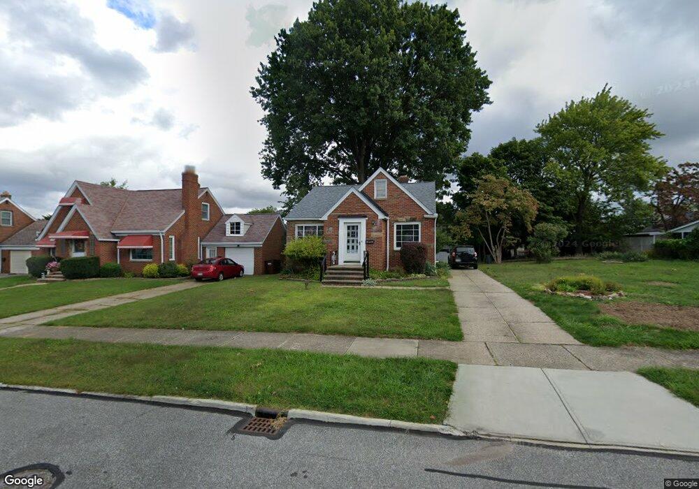
6614 Brownfield Dr Cleveland, OH 44129
Estimated Value: $202,000 - $226,000
3
Beds
1
Bath
1,477
Sq Ft
$147/Sq Ft
Est. Value
About This Home
This home is located at 6614 Brownfield Dr, Cleveland, OH 44129 and is currently estimated at $216,430, approximately $146 per square foot. 6614 Brownfield Dr is a home located in Cuyahoga County with nearby schools including Renwood Elementary School, Thoreau Park Elementary School, and Shiloh Middle School.
Ownership History
Date
Name
Owned For
Owner Type
Purchase Details
Closed on
Oct 15, 2015
Sold by
Conrad Neil A
Bought by
Conrad Neil Allan
Current Estimated Value
Purchase Details
Closed on
Apr 29, 1994
Sold by
Conrad Jane K
Bought by
Conrad Neil A
Purchase Details
Closed on
Jan 9, 1990
Sold by
Freeman Rose M
Bought by
Conrad Jane K
Purchase Details
Closed on
Jan 1, 1975
Bought by
Freeman Rose M
Create a Home Valuation Report for This Property
The Home Valuation Report is an in-depth analysis detailing your home's value as well as a comparison with similar homes in the area
Home Values in the Area
Average Home Value in this Area
Purchase History
| Date | Buyer | Sale Price | Title Company |
|---|---|---|---|
| Conrad Neil Allan | -- | Attorney | |
| Conrad Neil A | $78,500 | -- | |
| Conrad Jane K | -- | -- | |
| Freeman Rose M | -- | -- |
Source: Public Records
Tax History Compared to Growth
Tax History
| Year | Tax Paid | Tax Assessment Tax Assessment Total Assessment is a certain percentage of the fair market value that is determined by local assessors to be the total taxable value of land and additions on the property. | Land | Improvement |
|---|---|---|---|---|
| 2024 | $3,744 | $60,480 | $10,920 | $49,560 |
| 2023 | $2,977 | $40,780 | $9,660 | $31,120 |
| 2022 | $2,949 | $40,780 | $9,660 | $31,120 |
| 2021 | $3,036 | $40,780 | $9,660 | $31,120 |
| 2020 | $2,658 | $31,360 | $7,420 | $23,940 |
| 2019 | $2,545 | $89,600 | $21,200 | $68,400 |
| 2018 | $2,560 | $31,360 | $7,420 | $23,940 |
| 2017 | $2,299 | $26,050 | $5,780 | $20,270 |
| 2016 | $2,285 | $26,050 | $5,780 | $20,270 |
| 2015 | $2,119 | $26,050 | $5,780 | $20,270 |
| 2014 | $2,119 | $26,570 | $5,880 | $20,690 |
Source: Public Records
Map
Nearby Homes
- 6610 Renwood Dr
- 6708 Thornton Dr
- 6096 Wareham Dr
- 6143 Wareham Dr
- 6111 Manchester Rd
- 7014 Thornton Dr
- 6818 Hampstead Ave
- 6406 Sunderland Dr
- 6168 Manchester Rd
- 7115 Hampstead Ave
- 6136 Ridge Rd
- 6704 Charles Ave
- 5603 Allanwood Dr
- 6227 Ridge Rd
- 6234 N Canterbury Rd
- 6903 Alber Ave
- 5815 Wilber Ave
- 7706 Renwood Dr
- 7514 Spring Garden Rd
- 6706 Alber Ave
- 6618 Brownfield Dr
- 6606 Brownfield Dr
- 6706 Brownfield Dr
- 6519 Thornton Dr
- 6602 Brownfield Dr
- 6515 Thornton Dr
- 6603 Thornton Dr
- 6511 Thornton Dr
- 6611 Thornton Dr
- 6507 Thornton Dr
- 6514 Brownfield Dr
- 6710 Brownfield Dr
- 6615 Thornton Dr
- 6703 Brownfield Dr
- 6615 Brownfield Dr
- 6503 Thornton Dr
- 6503 Thornton Dr Unit 1950
- 6707 Brownfield Dr
- 6611 Brownfield Dr
- 6619 Thornton Dr