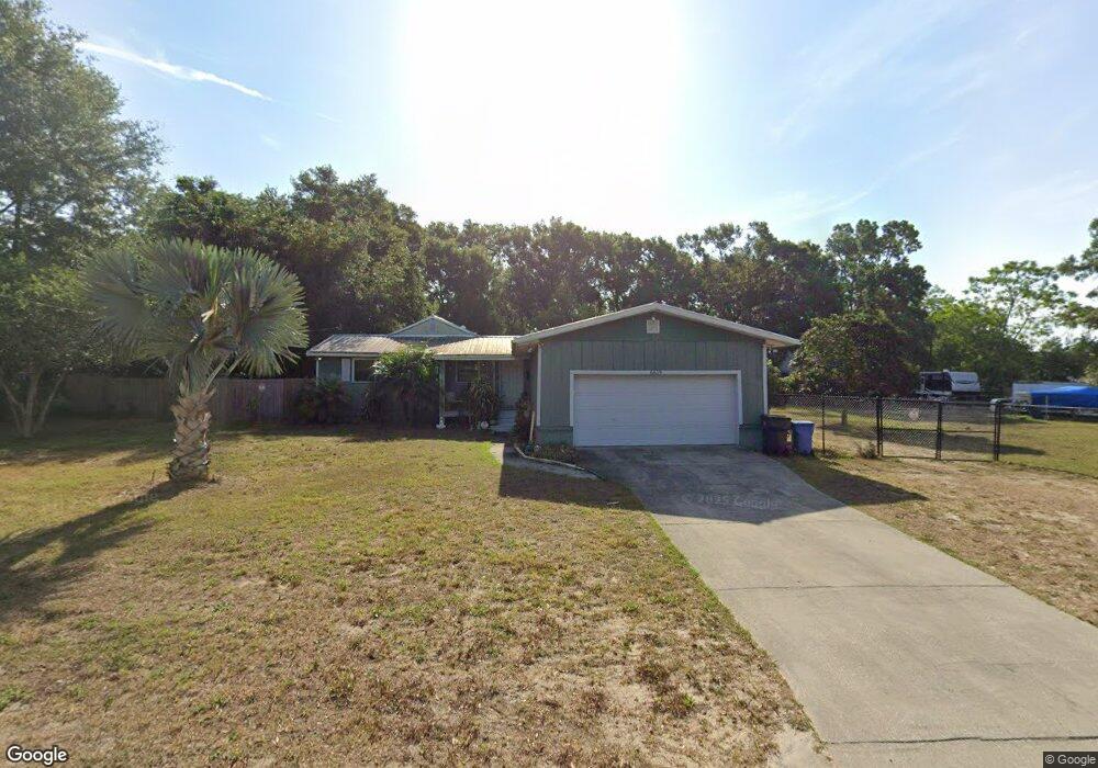
6619 Stark Rd Seffner, FL 33584
Estimated Value: $251,000 - $323,000
3
Beds
2
Baths
2,349
Sq Ft
$122/Sq Ft
Est. Value
About This Home
This home is located at 6619 Stark Rd, Seffner, FL 33584 and is currently estimated at $285,478, approximately $121 per square foot. 6619 Stark Rd is a home located in Hillsborough County with nearby schools including Mcdonald Elementary School, Jennings Middle School, and Armwood High School.
Ownership History
Date
Name
Owned For
Owner Type
Purchase Details
Closed on
Oct 1, 2016
Bought by
Pratt Marcus
Current Estimated Value
Purchase Details
Closed on
Aug 7, 2014
Sold by
Epps Kevin G
Bought by
Fuentes Stephanie E
Purchase Details
Closed on
Feb 19, 1997
Sold by
Little Carl D
Bought by
Little Carol and Little Carl D
Create a Home Valuation Report for This Property
The Home Valuation Report is an in-depth analysis detailing your home's value as well as a comparison with similar homes in the area
Home Values in the Area
Average Home Value in this Area
Purchase History
| Date | Buyer | Sale Price | Title Company |
|---|---|---|---|
| Pratt Marcus | $130,000 | -- | |
| Fuentes Stephanie E | -- | None Available | |
| Little Carol | $15,428 | -- |
Source: Public Records
Mortgage History
| Date | Status | Borrower | Loan Amount |
|---|---|---|---|
| Previous Owner | Little Carol | $51,758 |
Source: Public Records
Tax History
| Year | Tax Paid | Tax Assessment Tax Assessment Total Assessment is a certain percentage of the fair market value that is determined by local assessors to be the total taxable value of land and additions on the property. | Land | Improvement |
|---|---|---|---|---|
| 2025 | $564 | $96,021 | -- | -- |
| 2024 | $564 | $93,315 | -- | -- |
| 2023 | $524 | $90,597 | $0 | $0 |
| 2022 | $434 | $87,958 | $0 | $0 |
| 2021 | $1,209 | $85,396 | $0 | $0 |
| 2020 | $1,132 | $84,217 | $0 | $0 |
| 2019 | $1,053 | $82,324 | $0 | $0 |
| 2018 | $994 | $80,382 | $0 | $0 |
| 2017 | $968 | $78,729 | $0 | $0 |
| 2016 | $737 | $51,022 | $0 | $0 |
| 2015 | $744 | $50,667 | $0 | $0 |
| 2014 | $727 | $50,265 | $0 | $0 |
| 2013 | -- | $49,522 | $0 | $0 |
Source: Public Records
Map
Nearby Homes
- 11119 Bessie Dix Rd
- 0 Stark Rd Unit MFRTB8438572
- 579 W Us Highway 92
- 11340 Bessie Dix Rd
- 11357 Pruett Rd
- 11305 Broadview Rd
- 11228 Marlborough Dr
- 10003 Benjamin Smith Dr
- 10206 White Magnolia Square
- 10140 White Magnolia Square
- 9475 Oakleaf Hammock Place
- 7405 Williams Rd
- 9317 Lisbon St
- 9526 Clarkwild Place
- TBD - LOT 76 Taylor Road Heritage Estates Phase 2
- 9544 Clarkwild Place
- 10201 Timmons Rd
- 10190 Dolphin Gull Cir
- 10409 Leland Hawes Rd
- 9512 Summers Cay Cir
- 11505 Bessie Dix Rd
- 11506 Bessie Dix Rd
- 0 Seffner
- 0 Bessie Dix Rd Unit T2929967
- 0 Bessie Dix Rd Unit T2303024
- 0 Bessie Dix Rd Unit T2322697
- 0 Bessie Dix Rd Unit T2858636
- 0 Bessie Dix Rd Unit 14490.0 224070217
- 0 Bessie Dix Rd Unit MFRA4624275
- 0 Bessie Dix Rd Unit 224070217
- 0 Bessie Dix Rd Unit MFRT3503928
- 11507 Bessie Dix Rd
- 6613 Stark Rd
- 11502 Bessie Dix Rd
- 11504 Bessie Dix Rd
- 11416 Bessie Dix Rd
- 11418 Bessie Dix Rd
- 11513 Bessie Dix Rd
- 11517 Bessie Dix Rd
- 6716 Stark Rd
Your Personal Tour Guide
Ask me questions while you tour the home.