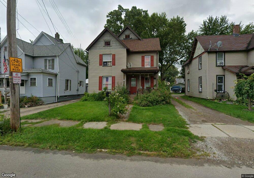
662 Broad St Conneaut, OH 44030
Estimated Value: $98,000 - $108,000
3
Beds
2
Baths
1,382
Sq Ft
$74/Sq Ft
Est. Value
About This Home
This home is located at 662 Broad St, Conneaut, OH 44030 and is currently estimated at $102,739, approximately $74 per square foot. 662 Broad St is a home located in Ashtabula County with nearby schools including Lakeshore Primary Elementary School, Gateway Elementary School, and Conneaut Middle School.
Ownership History
Date
Name
Owned For
Owner Type
Purchase Details
Closed on
Apr 28, 2008
Sold by
C & G Enterprises Llc
Bought by
Mcadoo Sampson and Mcadoo Sarah
Current Estimated Value
Home Financials for this Owner
Home Financials are based on the most recent Mortgage that was taken out on this home.
Original Mortgage
$60,549
Outstanding Balance
$38,345
Interest Rate
5.88%
Mortgage Type
FHA
Estimated Equity
$64,394
Purchase Details
Closed on
May 15, 2007
Sold by
Us Bank Na
Bought by
C & G Enterprises Llc
Purchase Details
Closed on
Jan 10, 2007
Sold by
Chance William
Bought by
Us Bank Na and The Structured Asset Investment Loan Tru
Purchase Details
Closed on
Apr 8, 2005
Sold by
Chance Tonya
Bought by
Chance William
Purchase Details
Closed on
Jan 14, 2005
Sold by
Young Ronald G and Young Dianne L
Bought by
Chance William H and Chance Tonya T
Home Financials for this Owner
Home Financials are based on the most recent Mortgage that was taken out on this home.
Original Mortgage
$58,500
Interest Rate
9.8%
Mortgage Type
Unknown
Purchase Details
Closed on
Oct 25, 2000
Sold by
Conneaut Savings Bank
Bought by
Young Ronald G and Young Diane L
Home Financials for this Owner
Home Financials are based on the most recent Mortgage that was taken out on this home.
Original Mortgage
$80,000
Interest Rate
8%
Mortgage Type
New Conventional
Purchase Details
Closed on
Apr 13, 2000
Sold by
Simmons Bill L
Bought by
Conneaut Savings & Loan Co
Purchase Details
Closed on
Feb 5, 1999
Sold by
Hamilton Bill
Bought by
Simmons Bill L and Simmons Bonnie A
Home Financials for this Owner
Home Financials are based on the most recent Mortgage that was taken out on this home.
Original Mortgage
$46,875
Interest Rate
7.5%
Mortgage Type
New Conventional
Purchase Details
Closed on
Sep 8, 1998
Sold by
Business Advisory Assoc
Bought by
Hamilton Bill and Hamilton Patricia
Create a Home Valuation Report for This Property
The Home Valuation Report is an in-depth analysis detailing your home's value as well as a comparison with similar homes in the area
Home Values in the Area
Average Home Value in this Area
Purchase History
| Date | Buyer | Sale Price | Title Company |
|---|---|---|---|
| Mcadoo Sampson | $61,500 | Chicago Title | |
| C & G Enterprises Llc | $25,000 | Accutitle Agency | |
| Us Bank Na | $30,000 | Buckeye Title Corp | |
| Chance William | -- | -- | |
| Chance William H | $53,550 | Tower City Title Agency Inc | |
| Young Ronald G | $44,000 | -- | |
| Conneaut Savings & Loan Co | $50,869 | -- | |
| Simmons Bill L | $62,500 | -- | |
| Hamilton Bill | $10,000 | -- |
Source: Public Records
Mortgage History
| Date | Status | Borrower | Loan Amount |
|---|---|---|---|
| Open | Mcadoo Sampson | $60,549 | |
| Previous Owner | Chance William H | $58,500 | |
| Previous Owner | Young Ronald G | $80,000 | |
| Previous Owner | Simmons Bill L | $46,875 |
Source: Public Records
Tax History Compared to Growth
Tax History
| Year | Tax Paid | Tax Assessment Tax Assessment Total Assessment is a certain percentage of the fair market value that is determined by local assessors to be the total taxable value of land and additions on the property. | Land | Improvement |
|---|---|---|---|---|
| 2024 | $1,826 | $24,960 | $3,220 | $21,740 |
| 2023 | $1,184 | $24,960 | $3,220 | $21,740 |
| 2022 | $1,036 | $19,220 | $2,490 | $16,730 |
| 2021 | $1,054 | $19,220 | $2,490 | $16,730 |
| 2020 | $1,053 | $19,220 | $2,490 | $16,730 |
| 2019 | $858 | $15,340 | $1,370 | $13,970 |
| 2018 | $819 | $15,340 | $1,370 | $13,970 |
| 2017 | $851 | $15,340 | $1,370 | $13,970 |
| 2016 | $875 | $17,920 | $1,610 | $16,310 |
| 2015 | $884 | $17,920 | $1,610 | $16,310 |
| 2014 | $783 | $17,920 | $1,610 | $16,310 |
| 2013 | $591 | $13,900 | $2,030 | $11,870 |
Source: Public Records
Map
Nearby Homes
- 622 Harbor St
- 169 River St
- 770 Buffalo St
- 644 Mill St
- 427 Harbor St
- 536 Mill St
- 413 Harbor St
- 375 Bliss Ave
- 386 Washington St
- 402 Broad St
- 179 Marshall St
- 0 Chestnut St Unit 5120761
- 973 Buffalo St
- 992 Mill St
- 146 Nickle Plate Ave
- 289 Harbor St
- 284 Clay St
- 143 Evergreen St
- 1025 Harbor St Unit 35
- 536 Madison St